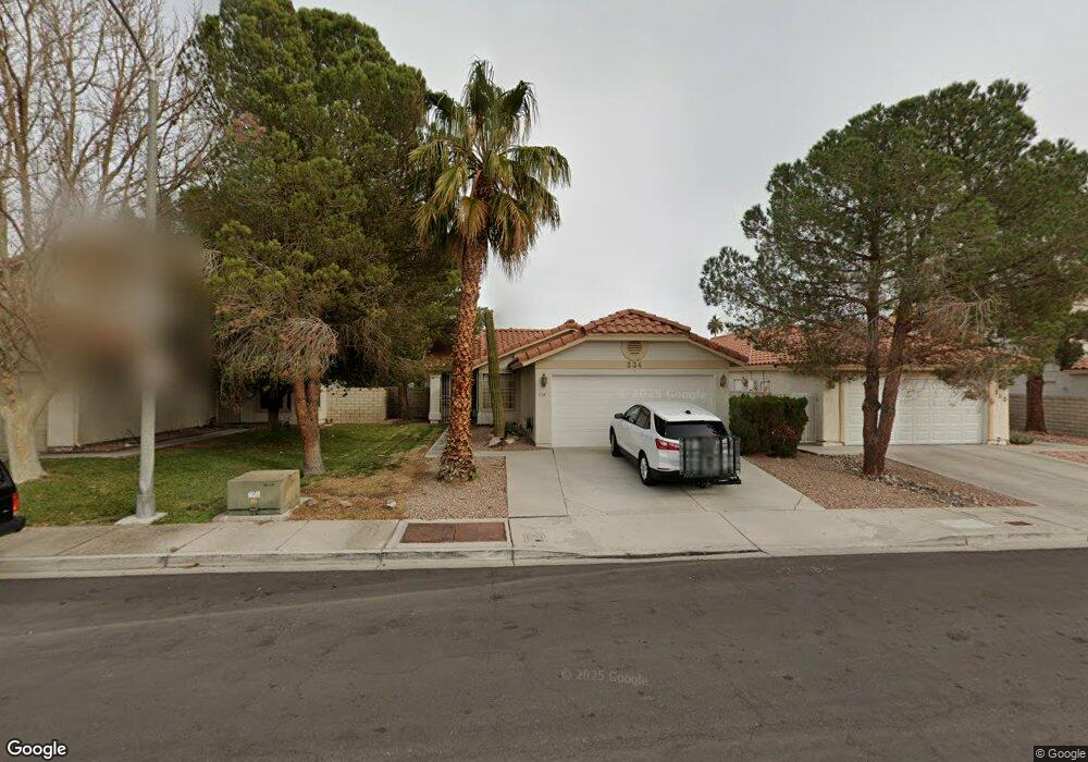
334 Keating St Henderson, NV 89074
Green Valley North NeighborhoodEstimated Value: $379,726 - $391,000
3
Beds
2
Baths
1,165
Sq Ft
$331/Sq Ft
Est. Value
About This Home
This home is located at 334 Keating St, Henderson, NV 89074 and is currently estimated at $385,932, approximately $331 per square foot. 334 Keating St is a home located in Clark County with nearby schools including Nate Mack Elementary School, Barbara and Hank Greenspun Junior High School, and Green Valley High School.
Ownership History
Date
Name
Owned For
Owner Type
Purchase Details
Closed on
May 22, 2024
Sold by
Desio Lila
Bought by
Lila De Sio Revocable Living Trust and De Sio
Current Estimated Value
Purchase Details
Closed on
Oct 26, 1993
Sold by
Crossley Carlotta C
Bought by
Desio Lila
Home Financials for this Owner
Home Financials are based on the most recent Mortgage that was taken out on this home.
Original Mortgage
$80,000
Interest Rate
6.97%
Create a Home Valuation Report for This Property
The Home Valuation Report is an in-depth analysis detailing your home's value as well as a comparison with similar homes in the area
Home Values in the Area
Average Home Value in this Area
Purchase History
| Date | Buyer | Sale Price | Title Company |
|---|---|---|---|
| Lila De Sio Revocable Living Trust | -- | None Listed On Document | |
| Desio Lila | $103,500 | United Title |
Source: Public Records
Mortgage History
| Date | Status | Borrower | Loan Amount |
|---|---|---|---|
| Previous Owner | Desio Lila | $80,000 |
Source: Public Records
Tax History Compared to Growth
Tax History
| Year | Tax Paid | Tax Assessment Tax Assessment Total Assessment is a certain percentage of the fair market value that is determined by local assessors to be the total taxable value of land and additions on the property. | Land | Improvement |
|---|---|---|---|---|
| 2025 | $1,350 | $71,149 | $35,000 | $36,149 |
| 2024 | $1,311 | $71,149 | $35,000 | $36,149 |
| 2023 | $1,311 | $68,118 | $33,250 | $34,868 |
| 2022 | $1,273 | $59,932 | $27,720 | $32,212 |
| 2021 | $1,236 | $56,480 | $25,550 | $30,930 |
| 2020 | $1,197 | $54,776 | $23,800 | $30,976 |
| 2019 | $1,162 | $52,431 | $21,700 | $30,731 |
| 2018 | $1,128 | $47,729 | $17,850 | $29,879 |
| 2017 | $1,382 | $47,664 | $17,150 | $30,514 |
| 2016 | $1,069 | $43,911 | $12,950 | $30,961 |
| 2015 | $1,066 | $41,001 | $10,850 | $30,151 |
| 2014 | $1,035 | $36,515 | $9,275 | $27,240 |
Source: Public Records
Map
Nearby Homes
- 353 Clayton St
- 347 Amalfi St
- 2520 Machado Dr
- 319 Carrington St
- 7483 Forestdale Ct
- 2670 Ridgewater Cir
- 338 Abbington St
- 346 Abbington St
- 2250 Bowie Cir
- 2249 Darwin Cir
- 2343 Villandry Ct
- 2657 Storey Cir
- 314 Lander Dr
- 367 Lander Dr
- 2544 Wellworth Ave
- 13 Dovetail Cir
- 353 Lander Terrace
- 2709 Briarcliff Ave
- 2224 Lucerne Ct
- 2222 Lucerne Ct
- 336 Keating St
- 332 Keating St
- 338 Keating St Unit 422
- 330 Keating St
- 330 Keating St Unit na
- 345 Clayton St
- 343 Clayton St
- 347 Clayton St
- 2560 Machado Dr
- 340 Keating St
- 341 Clayton St
- 335 Keating St
- 2562 Machado Dr
- 349 Clayton St
- 342 Keating St
- 337 Keating St Unit 422
- 321 Brent Ct
- 2564 Machado Dr Unit 422
- 316 Birmingham St
- 339 Keating St