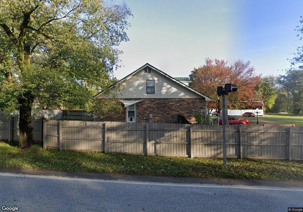
334 Phillips St West Fork, AR 72774
Estimated Value: $316,000 - $393,000
--
Bed
3
Baths
2,395
Sq Ft
$155/Sq Ft
Est. Value
About This Home
This home is located at 334 Phillips St, West Fork, AR 72774 and is currently estimated at $371,007, approximately $154 per square foot. 334 Phillips St is a home located in Washington County with nearby schools including West Fork Elementary School, West Fork Middle School, and West Fork High School.
Ownership History
Date
Name
Owned For
Owner Type
Purchase Details
Closed on
Apr 9, 1997
Bought by
Wiltse James E
Current Estimated Value
Purchase Details
Closed on
Apr 18, 1996
Bought by
Bank Of Fayetteville
Purchase Details
Closed on
Jan 16, 1991
Bought by
Palmer Melvin J
Purchase Details
Closed on
Jan 1, 1985
Bought by
Ward Hubert Lee and Linda Loftin
Create a Home Valuation Report for This Property
The Home Valuation Report is an in-depth analysis detailing your home's value as well as a comparison with similar homes in the area
Home Values in the Area
Average Home Value in this Area
Purchase History
| Date | Buyer | Sale Price | Title Company |
|---|---|---|---|
| Wiltse James E | $105,000 | -- | |
| Bank Of Fayetteville | -- | -- | |
| Palmer Melvin J | $25,000 | -- | |
| Ward Hubert Lee | -- | -- |
Source: Public Records
Tax History Compared to Growth
Tax History
| Year | Tax Paid | Tax Assessment Tax Assessment Total Assessment is a certain percentage of the fair market value that is determined by local assessors to be the total taxable value of land and additions on the property. | Land | Improvement |
|---|---|---|---|---|
| 2025 | $1,836 | $69,010 | $14,500 | $54,510 |
| 2024 | $1,932 | $69,010 | $14,500 | $54,510 |
| 2023 | $1,911 | $69,010 | $14,500 | $54,510 |
| 2022 | $1,851 | $48,470 | $7,250 | $41,220 |
| 2021 | $1,756 | $48,470 | $7,250 | $41,220 |
| 2020 | $1,660 | $48,470 | $7,250 | $41,220 |
| 2019 | $1,565 | $36,530 | $6,250 | $30,280 |
| 2018 | $1,590 | $36,530 | $6,250 | $30,280 |
| 2017 | $1,535 | $36,530 | $6,250 | $30,280 |
| 2016 | $1,532 | $36,530 | $6,250 | $30,280 |
| 2015 | $1,446 | $36,530 | $6,250 | $30,280 |
| 2014 | $1,359 | $33,120 | $7,000 | $26,120 |
Source: Public Records
Map
Nearby Homes
- 302 Mcknight Ave
- 0000 Highway 170
- 185 Wheeler St
- 321 Cedar Springs Place
- 121 & 129 Main St
- 340 W Smith St
- 327 W Smith St
- 385 W Smith St
- 393 W Smith St
- 365 W Smith St
- 359 W Smith St
- 339 W Smith St
- Springs 1445 Plan at Rolling Plains
- Eureka 1536 Plan at Rolling Plains
- Oak 1463 Plan at Rolling Plains
- Magnolia 1556 Plan at Rolling Plains
- Ashton 1496 Plan at Rolling Plains
- Ouachita 1669 Plan at Rolling Plains
- Osage 1567 Plan at Rolling Plains
- Maple 1659 Plan at Rolling Plains
- 344 Phillips St
- 327 Phillips St
- 14658 Arkansas 170
- J0 Arkansas 170
- --- Arkansas 170
- Off Arkansas 170
- - Arkansas 170
- . Arkansas 170
- 14514 Arkansas 170
- 19209 Arkansas 170
- 19145 Arkansas 170
- 14581 Arkansas 170
- 15972 Arkansas 170
- 356 Phillips St
- 000 Mcknight Ave Unit 10662 Union Star Chu
- 320 White St
- 312 Phillips St
- 366 Phillips St
- 235 Mcknight Ave
- 0 McKnight 6 865a Unit 681563