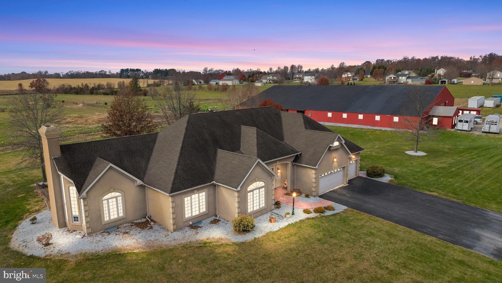
334 Rolling Ln Unit 2 Abbottstown, PA 17301
Estimated payment $8,311/month
Highlights
- Barn or Stable
- 26.34 Acre Lot
- Contemporary Architecture
- Gourmet Kitchen
- Pasture Views
- Vaulted Ceiling
About This Home
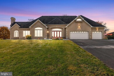
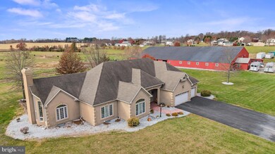
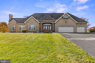
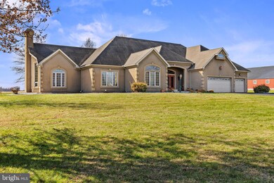
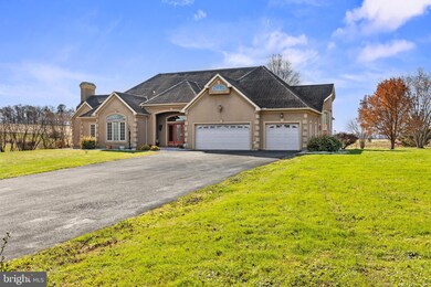
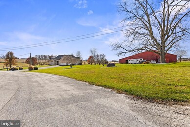
334 Rolling Lane, Abbottstown, PA – One-of-a-Kind Equestrian Estate Welcome to this remarkable 26+ acre equestrian estate nestled in the heart of Abbottstown, Pennsylvania. Perfectly designed for the passionate horse enthusiast, this exceptional property features fenced pastures, an indoor riding arena, multiple stalls, and an on-site office, providing a true turn-key setup for boarding, training, or private enjoyment. The centerpiece of the property is a custom-built 3,200+ sq. ft. home, thoughtfully crafted with comfort, elegance, and functionality in mind. Step inside to a grand living area with soaring 20-foot vaulted ceilings that flow seamlessly into the open-concept family room and gourmet kitchen. The chef’s kitchen is a showstopper, featuring granite countertops, custom cabinetry, a large island, and a cozy fireplace, perfect for entertaining or relaxing evenings at home. This beautiful home offers three spacious bedrooms and three full baths, including an impressive owner’s suite with dual primary bathrooms and serene views overlooking the rolling pastures. A separate formal dining area and abundant natural light throughout create a sense of warmth and sophistication. Outside, enjoy the peaceful setting with a private pond, open skies, and breathtaking panoramic views of your fenced acreage. Conveniently located near Route 30, this property offers easy access to nearby towns and amenities while maintaining privacy and tranquility. Whether you’re a professional equestrian, hobbyist, or simply seeking the perfect countryside retreat, 334 Rolling Lane delivers an unparalleled blend of luxury living and equestrian excellence
Listing Agent
(717) 344-5950 ironvalleycarlisle@gmail.com Iron Valley Real Estate of Central PA Brokerage Phone: 7173445950 Listed on: 11/15/2025

Home Details
Home Type
- Single Family
Est. Annual Taxes
- $9,083
Year Built
- Built in 2006
Lot Details
- 26.34 Acre Lot
- Property is in very good condition
- Property is zoned RURAL AGRICULTURAL
Home Design
- Contemporary Architecture
- Concrete Perimeter Foundation
- Stucco
Interior Spaces
- Property has 1 Level
- Built-In Features
- Crown Molding
- Vaulted Ceiling
- Ceiling Fan
- Recessed Lighting
- 2 Fireplaces
- Formal Dining Room
- Pasture Views
Kitchen
- Gourmet Kitchen
- Breakfast Area or Nook
- Built-In Double Oven
- Range Hood
- Built-In Microwave
- Dishwasher
- Stainless Steel Appliances
- Kitchen Island
Flooring
- Wood
- Carpet
Bedrooms and Bathrooms
- 3 Main Level Bedrooms
- En-Suite Bathroom
- Walk-In Closet
- 3 Full Bathrooms
- Hydromassage or Jetted Bathtub
- Bathtub with Shower
- Walk-in Shower
Laundry
- Electric Dryer
- Washer
Basement
- Basement Fills Entire Space Under The House
- Interior Basement Entry
- Rough-In Basement Bathroom
Parking
- 3 Parking Spaces
- 3 Attached Carport Spaces
Outdoor Features
- Patio
- Outbuilding
- Porch
Horse Facilities and Amenities
- Horses Allowed On Property
- Paddocks
- Run-In Shed
- Barn or Stable
- Indoor Arena
- Stables
- Arena
- Riding Ring
Utilities
- Forced Air Heating and Cooling System
- Heating System Uses Natural Gas
- Vented Exhaust Fan
- Well
- Natural Gas Water Heater
- On Site Septic
Community Details
- No Home Owners Association
Listing and Financial Details
- Tax Lot 0001
- Assessor Parcel Number 17L10-0001---000
Map
Tax History
We collect this data history from publicly available records. To have your information removed, we recommend requesting removal directly through your county’s website.
| Year | Tax Paid | Tax Assessment Tax Assessment Total Assessment is a certain percentage of the fair market value that is determined by local assessors to be the total taxable value of land and additions on the property. | Land | Improvement |
|---|---|---|---|---|
| 2026 | $9,083 | $393,100 | $19,000 | $374,100 |
| 2025 | $8,912 | $393,100 | $19,000 | $374,100 |
| 2024 | $8,193 | $393,100 | $19,000 | $374,100 |
| 2023 | $13,828 | $393,100 | $19,000 | $374,100 |
| 2022 | $13,377 | $393,100 | $19,000 | $374,100 |
| 2021 | $13,012 | $393,100 | $19,000 | $374,100 |
| 2020 | $12,687 | $393,100 | $19,000 | $374,100 |
| 2019 | $12,408 | $393,100 | $19,000 | $374,100 |
| 2018 | $12,129 | $393,100 | $19,000 | $374,100 |
| 2017 | $6,600 | $393,100 | $19,000 | $374,100 |
| 2016 | -- | $393,100 | $19,000 | $374,100 |
| 2015 | -- | $391,400 | $17,300 | $374,100 |
| 2014 | -- | $389,800 | $15,700 | $374,100 |
Property History
We collect this data history from publicly available records. To have your information removed, we recommend requesting removal directly through your county’s website.
| Date | Event | Price | List to Sale | Price per Sq Ft |
|---|---|---|---|---|
| 06/01/2026 06/01/26 | Price Changed | $1,399,900 | -12.5% | $446 / Sq Ft |
| 03/31/2026 03/31/26 | For Sale | $1,599,900 | 0.0% | $510 / Sq Ft |
| 03/18/2026 03/18/26 | Off Market | $1,599,900 | -- | -- |
| 03/17/2026 03/17/26 | Price Changed | $1,599,900 | -5.9% | $510 / Sq Ft |
| 03/11/2026 03/11/26 | Price Changed | $1,699,900 | -10.5% | $542 / Sq Ft |
| 11/15/2025 11/15/25 | For Sale | $1,899,900 | -- | $606 / Sq Ft |
Purchase History
We collect this data history from publicly available records. To have your information removed, we recommend requesting removal directly through your county’s website.
| Date | Type | Sale Price | Title Company |
|---|---|---|---|
| Interfamily Deed Transfer | -- | -- |
Mortgage History
We collect this data history from publicly available records. To have your information removed, we recommend requesting removal directly through your county’s website.
| Date | Status | Loan Amount | Loan Type |
|---|---|---|---|
| Closed | $170,000 | Credit Line Revolving | |
| Closed | $417,000 | New Conventional |
Source: Bright MLS
MLS Number: PAAD2020652
APN: 17-L10-0001-000
Disclaimer: Certain information contained herein is derived from information provided by parties other than Homes.com. All information provided is deemed reliable, but is not guaranteed to be accurate and should be independently verified.
![]() The data relating to real estate for sale on this website appears in part through the BRIGHT Internet Data Exchange program, a voluntary cooperative exchange of property listing data between licensed real estate brokerage firms, and is provided by BRIGHT through a licensing agreement.
The data relating to real estate for sale on this website appears in part through the BRIGHT Internet Data Exchange program, a voluntary cooperative exchange of property listing data between licensed real estate brokerage firms, and is provided by BRIGHT through a licensing agreement.
Listing information is from various brokers who participate in the Bright MLS IDX program and not all listings may be visible on the site.
The property information being provided on or through the website is for the personal, non-commercial use of consumers and such information may not be used for any purpose other than to identify prospective properties consumers may be interested in purchasing.
Some properties which appear for sale on the website may no longer be available because they are for instance, under contract, sold or are no longer being offered for sale.
Property information displayed is deemed reliable but is not guaranteed.
Copyright 2026 Bright MLS, Inc.
- 39 N Pheasant Way Unit 52
- 29 Hughes Dr Unit 5
- 140 Hamilton Dr Unit 25
- 35 Fox Meadow Dr Unit 13
- 103 W King St
- 255 Kinneman Rd
- 124 Lobell Rd
- 42 Lobell Rd
- 221 Kinneman Rd Unit 28
- 7705 Altland Ave
- 7666 Lincoln Hwy
- 7630 Lincoln Hwy
- 32 Pine Rd
- 36 Pine Rd
- 324 Crystal Creek Crossing
- 38 Stanley Dr
- 117 Frog Pond Hollow
- 454 Race Track Rd
- 5 Chesapeake Dr
- 110 Frog Pond Hollow
- 119 Katelyn Dr
- 7322 Lincoln Hwy W
- 7324 Lincoln Hwy
- 333 W King St Unit B
- 0 Baldwin Ct
- 48 Skyview Cir
- 10 Skyview Cir
- 5056 E Berlin Rd Unit 2ND FL
- 5056 E Berlin Rd Unit GARAGE A
- 5056 E Berlin Rd Unit GARAGE B
- 5056 E Berlin Rd
- 21 Birch Dr
- 203 W Clearview Rd
- 662 1/2 Broadway Unit 662 1/2
- 650 Broadway Unit 2nd Floor
- 6 5th St Unit B
- 612 Maple Ave
- 514 Broadway Unit 1st Floor
- 519 Broadway Unit 2
- 28 Mccosh St
Ask me questions while you tour the home.