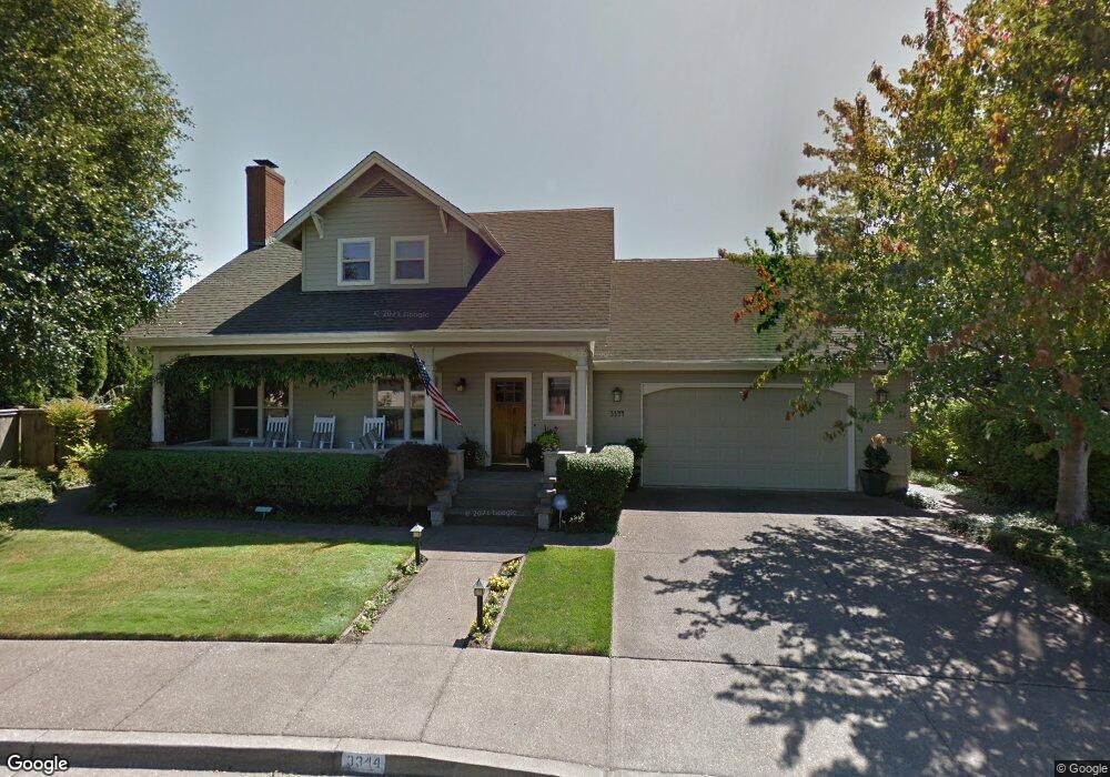
3344 Saint Croix St Eugene, OR 97408
Harlow NeighborhoodEstimated Value: $787,000 - $940,000
3
Beds
3
Baths
2,772
Sq Ft
$309/Sq Ft
Est. Value
About This Home
This home is located at 3344 Saint Croix St, Eugene, OR 97408 and is currently estimated at $857,790, approximately $309 per square foot. 3344 Saint Croix St is a home located in Lane County with nearby schools including Gilham Elementary School, Cal Young Middle School, and Sheldon High School.
Ownership History
Date
Name
Owned For
Owner Type
Purchase Details
Closed on
Dec 9, 2009
Sold by
Anderson David E and Anderson Carol H
Bought by
Cole Todd S and Cole Deanna L
Current Estimated Value
Home Financials for this Owner
Home Financials are based on the most recent Mortgage that was taken out on this home.
Original Mortgage
$352,000
Outstanding Balance
$229,028
Interest Rate
5.01%
Mortgage Type
New Conventional
Estimated Equity
$628,762
Create a Home Valuation Report for This Property
The Home Valuation Report is an in-depth analysis detailing your home's value as well as a comparison with similar homes in the area
Home Values in the Area
Average Home Value in this Area
Purchase History
We collect this data history from publicly available records. To have your information removed, we recommend requesting removal directly through your county’s website.
| Date | Buyer | Sale Price | Title Company |
|---|---|---|---|
| Cole Todd S | $440,000 | First American Title |
Source: Public Records
Mortgage History
We collect this data history from publicly available records. To have your information removed, we recommend requesting removal directly through your county’s website.
| Date | Status | Borrower | Loan Amount |
|---|---|---|---|
| Open | Cole Todd S | $352,000 |
Source: Public Records
Tax History
| Year | Tax Paid | Tax Assessment Tax Assessment Total Assessment is a certain percentage of the fair market value that is determined by local assessors to be the total taxable value of land and additions on the property. | Land | Improvement |
|---|---|---|---|---|
| 2025 | $9,703 | $497,979 | -- | -- |
| 2024 | $9,582 | $483,475 | -- | -- |
| 2023 | $9,582 | $469,394 | $0 | $0 |
| 2022 | $8,976 | $455,723 | $0 | $0 |
| 2021 | $8,431 | $442,450 | $0 | $0 |
| 2020 | $8,263 | $429,564 | $0 | $0 |
| 2019 | $7,934 | $417,053 | $0 | $0 |
| 2018 | $7,403 | $393,113 | $0 | $0 |
| 2017 | $6,974 | $393,113 | $0 | $0 |
| 2016 | $6,646 | $381,663 | $0 | $0 |
| 2015 | $6,436 | $370,547 | $0 | $0 |
| 2014 | $6,313 | $359,754 | $0 | $0 |
Source: Public Records
Map
Nearby Homes
- 2909 Lord Byron Place
- 3017 Lord Byron Place
- 3220 Crescent Ave Unit 66
- 3220 Crescent Ave Unit 18
- 2838 Martinique Ave
- 109 Hillview 1
- 3075 Guadalupe Way
- 1798 Duke Ct
- 2527 Park View Dr
- 2461 Mountain Terrace
- 1639 Victorian Way
- 1625 Victorian Way
- 2742 Wingate St
- 89805 Sprague Rd
- 2578 Willona Dr
- 2775 Elysium Ave
- 1564 Regency Dr
- 2515 Willona Dr
- 3387 Winchester Way
- 2577 Elysium Ave
- 3377 Saint Thomas St
- 2708 Saint Lucia Ave
- 3355 Saint Thomas St
- 2708 Saint Lucia St
- 3388 Saint Croix St
- 2722 Saint Lucia St
- 3333 Saint Thomas St
- 3386 Saint Thomas St
- 3364 Saint Thomas St
- 3310 Saint Croix St
- 3392 Saint Thomas St
- 3342 Saint Thomas St
- 2715 Saint Lucia St
- 3311 Saint Thomas St
- 3363 Saint Croix St
- 3394 Saint Thomas St
- 3391 Saint Croix St
- 2729 Saint Lucia Ave
- 3395 Saint Thomas St
- 3320 Saint Thomas St
Your Personal Tour Guide
Ask me questions while you tour the home.