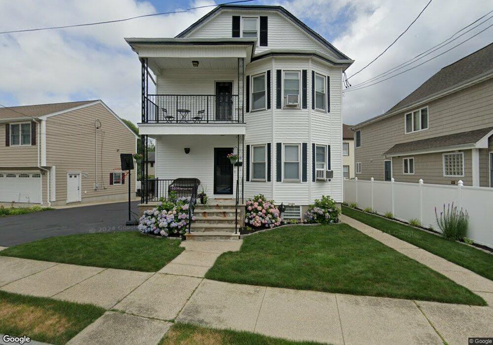
336 Conduit St New Bedford, MA 02745
Acushnet Station NeighborhoodEstimated Value: $471,424 - $542,000
6
Beds
3
Baths
2,334
Sq Ft
$219/Sq Ft
Est. Value
About This Home
This home is located at 336 Conduit St, New Bedford, MA 02745 and is currently estimated at $510,106, approximately $218 per square foot. 336 Conduit St is a home located in Bristol County with nearby schools including Jireh Swift School, Normandin Middle School, and New Bedford High School.
Ownership History
Date
Name
Owned For
Owner Type
Purchase Details
Closed on
Mar 1, 2019
Sold by
Lopes Antonio M and Lopes Ana C
Bought by
Lopes Krystal and Lopes Michael
Current Estimated Value
Home Financials for this Owner
Home Financials are based on the most recent Mortgage that was taken out on this home.
Original Mortgage
$255,000
Outstanding Balance
$224,188
Interest Rate
4.4%
Mortgage Type
New Conventional
Estimated Equity
$285,918
Create a Home Valuation Report for This Property
The Home Valuation Report is an in-depth analysis detailing your home's value as well as a comparison with similar homes in the area
Home Values in the Area
Average Home Value in this Area
Purchase History
| Date | Buyer | Sale Price | Title Company |
|---|---|---|---|
| Lopes Krystal | $255,000 | -- | |
| Lopes Krystal | $255,000 | -- |
Source: Public Records
Mortgage History
| Date | Status | Borrower | Loan Amount |
|---|---|---|---|
| Open | Lopes Krystal | $255,000 | |
| Closed | Lopes Krystal | $255,000 |
Source: Public Records
Tax History Compared to Growth
Tax History
| Year | Tax Paid | Tax Assessment Tax Assessment Total Assessment is a certain percentage of the fair market value that is determined by local assessors to be the total taxable value of land and additions on the property. | Land | Improvement |
|---|---|---|---|---|
| 2025 | $4,903 | $433,500 | $109,100 | $324,400 |
| 2024 | $4,319 | $359,900 | $109,100 | $250,800 |
| 2023 | $4,008 | $280,500 | $87,600 | $192,900 |
| 2022 | $3,650 | $234,900 | $83,500 | $151,400 |
| 2021 | $3,662 | $234,900 | $83,500 | $151,400 |
| 2020 | $3,694 | $228,600 | $83,500 | $145,100 |
| 2019 | $3,656 | $222,000 | $83,500 | $138,500 |
| 2018 | $3,504 | $210,700 | $83,500 | $127,200 |
| 2017 | $3,169 | $189,900 | $80,200 | $109,700 |
| 2016 | $3,009 | $182,500 | $77,000 | $105,500 |
| 2015 | $2,816 | $179,000 | $77,000 | $102,000 |
| 2014 | $2,674 | $176,400 | $73,800 | $102,600 |
Source: Public Records
Map
Nearby Homes
- 217 Dawson St
- 344 Conduit St
- 209 Dawson St Unit 211
- 339 Conduit St
- 225 Dawson St
- 207 Dawson St
- 218 Dawson St
- 214 Dawson St
- 11 Kingston St
- 354 Conduit St
- 208 Dawson St Unit 210
- 14 Rutland St
- 200 Dawson St Unit 202
- 227 Dawson St Unit 229
- 349 Conduit St Unit 351
- 318 Conduit St
- 318 Conduit St Unit 2
- 196 Dawson St Unit 198
- 21 Kingston St Unit 23
- 321 Conduit St