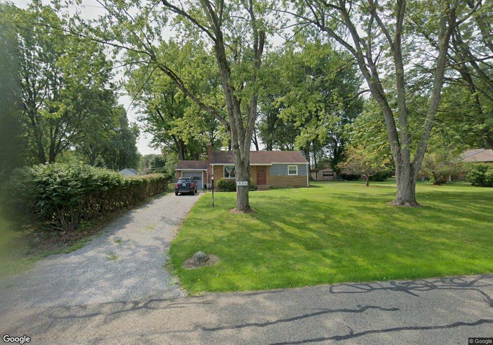
336 Maplewood Dr Alliance, OH 44601
Estimated Value: $175,000 - $225,000
2
Beds
2
Baths
936
Sq Ft
$214/Sq Ft
Est. Value
About This Home
This home is located at 336 Maplewood Dr, Alliance, OH 44601 and is currently estimated at $200,000, approximately $213 per square foot. 336 Maplewood Dr is a home located in Stark County with nearby schools including Alliance Elementary School at Rockhill, Alliance Intermediate School at Northside, and Alliance Middle School.
Ownership History
Date
Name
Owned For
Owner Type
Purchase Details
Closed on
Jan 12, 2022
Sold by
Tucker Joseph F
Bought by
Tucker Joseph F and Forsyth Dillon
Current Estimated Value
Purchase Details
Closed on
Sep 23, 2021
Sold by
Rosenberger Rollin D and Johnson Shari R
Bought by
Tucker Joseph F
Home Financials for this Owner
Home Financials are based on the most recent Mortgage that was taken out on this home.
Original Mortgage
$84,700
Interest Rate
2.8%
Mortgage Type
New Conventional
Purchase Details
Closed on
Oct 7, 1994
Sold by
Zamigias Christopher
Bought by
Rosenberger Rollin D
Home Financials for this Owner
Home Financials are based on the most recent Mortgage that was taken out on this home.
Original Mortgage
$74,000
Interest Rate
9.25%
Mortgage Type
New Conventional
Create a Home Valuation Report for This Property
The Home Valuation Report is an in-depth analysis detailing your home's value as well as a comparison with similar homes in the area
Home Values in the Area
Average Home Value in this Area
Purchase History
| Date | Buyer | Sale Price | Title Company |
|---|---|---|---|
| Tucker Joseph F | -- | Pidgeon Emilie K | |
| Tucker Joseph F | $121,000 | Heritage Union Title Co Ltd | |
| Rosenberger Rollin D | $74,000 | -- |
Source: Public Records
Mortgage History
| Date | Status | Borrower | Loan Amount |
|---|---|---|---|
| Previous Owner | Tucker Joseph F | $84,700 | |
| Previous Owner | Rosenberger Rollin D | $74,000 |
Source: Public Records
Tax History Compared to Growth
Tax History
| Year | Tax Paid | Tax Assessment Tax Assessment Total Assessment is a certain percentage of the fair market value that is determined by local assessors to be the total taxable value of land and additions on the property. | Land | Improvement |
|---|---|---|---|---|
| 2025 | -- | $5,610 | $4,730 | $880 |
| 2024 | -- | $5,610 | $4,730 | $880 |
| 2023 | $262 | $6,620 | $5,780 | $840 |
| 2022 | $264 | $6,620 | $5,780 | $840 |
| 2021 | $264 | $6,620 | $5,780 | $840 |
| 2020 | $245 | $5,710 | $4,970 | $740 |
| 2019 | $241 | $5,710 | $4,970 | $740 |
| 2018 | $818 | $5,710 | $4,970 | $740 |
| 2017 | $211 | $4,560 | $3,610 | $950 |
| 2016 | $209 | $4,560 | $3,610 | $950 |
| 2015 | $211 | $4,560 | $3,610 | $950 |
| 2014 | $198 | $4,060 | $3,220 | $840 |
| 2013 | $99 | $4,060 | $3,220 | $840 |
Source: Public Records
Map
Nearby Homes
- 2705 Shunk Ave
- 2839 S Rockhill Ave
- 3101 Ridgehill Ave
- 236 E Milton St
- 1059 Oakwood Dr
- 277 W Carol St
- 2460 S Arch Ave
- 2408 S Linden Ave
- 555 E Milton St
- 317 E State St
- 2218 S Freedom Ave
- 3709 S Union Ave
- 2376 S Seneca Ave
- 884 W College Rd
- 1325 W Beech St
- 2195 Blenheim Ave
- 112 E College St
- 2112 Blenheim Ave
- 1515 S Rockhill Ave
- 853 Fairway Dr
- 336 Maplewood Dr
- 340 Maplewood Dr
- 392 Maplewood Dr
- 392 Maplewood Dr
- 363 Linwood Dr
- 375 Linwood Dr
- 351 Linwood Dr
- 367 Maplewood Dr
- 387 Linwood Dr
- 379 Maplewood Dr
- 337 Linwood Dr
- 345 Maplewood Dr
- 391 Maplewood Dr
- 416 Maplewood Dr
- 325 Maplewood Dr
- 399 Maplewood Dr
- 315 Linwood Dr
- 420 Maplewood Dr
- 280 Maplewood Dr
- 407 Linwood Dr