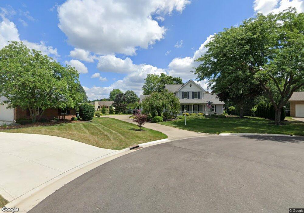
3360 Malory Cir NW Canton, OH 44708
Estimated Value: $393,000 - $432,000
4
Beds
3
Baths
3,060
Sq Ft
$133/Sq Ft
Est. Value
About This Home
This home is located at 3360 Malory Cir NW, Canton, OH 44708 and is currently estimated at $405,759, approximately $132 per square foot. 3360 Malory Cir NW is a home located in Stark County with nearby schools including Lake Cable Elementary School, Jackson Memorial Middle School, and Jackson High School.
Ownership History
Date
Name
Owned For
Owner Type
Purchase Details
Closed on
Mar 10, 2021
Sold by
Estate Of Sue E Monsell
Bought by
Monsell Frederick G
Current Estimated Value
Create a Home Valuation Report for This Property
The Home Valuation Report is an in-depth analysis detailing your home's value as well as a comparison with similar homes in the area
Home Values in the Area
Average Home Value in this Area
Purchase History
| Date | Buyer | Sale Price | Title Company |
|---|---|---|---|
| Monsell Frederick G | -- | None Available |
Source: Public Records
Tax History Compared to Growth
Tax History
| Year | Tax Paid | Tax Assessment Tax Assessment Total Assessment is a certain percentage of the fair market value that is determined by local assessors to be the total taxable value of land and additions on the property. | Land | Improvement |
|---|---|---|---|---|
| 2025 | -- | $132,860 | $26,460 | $106,400 |
| 2024 | -- | $132,860 | $26,460 | $106,400 |
| 2023 | $4,243 | $94,430 | $21,700 | $72,730 |
| 2022 | $4,243 | $94,430 | $21,700 | $72,730 |
| 2021 | $4,260 | $94,430 | $21,700 | $72,730 |
| 2020 | $3,766 | $78,370 | $18,690 | $59,680 |
| 2019 | $3,628 | $78,370 | $18,690 | $59,680 |
| 2018 | $3,646 | $78,370 | $18,690 | $59,680 |
| 2017 | $3,647 | $75,010 | $14,320 | $60,690 |
| 2016 | $3,671 | $75,010 | $14,320 | $60,690 |
| 2015 | $3,716 | $75,010 | $14,320 | $60,690 |
| 2014 | $1,697 | $71,790 | $13,690 | $58,100 |
| 2013 | $1,820 | $71,790 | $13,690 | $58,100 |
Source: Public Records
Map
Nearby Homes
- 5966 Hawks Nest Cir NW
- 3633 Barrington Place NW
- 0 Bertram Ave NW Unit 5051955
- 5843 Hawks Nest Cir NW
- 5878 Hawks Nest Cir NW Unit 16B
- 5846 Hawks Nest Cir NW
- 5845 Hawks Nest Cir NW
- 5848 Hawks Nest Cir NW
- 5879 Hawks Nest Cir NW
- 5877 Hawks Nest Cir NW
- 5875 Hawks Nest Cir NW
- 5851 Hawks Nest Cir NW
- 5869 Hawks Nest Cir NW
- 5853 Hawks Nest Cir NW
- 5867 Hawks Nest Cir NW
- 3273 Dellwood Ave NW
- 6175 Bertram Ave NW
- 3722 Old Hickory Ave NW Unit 3A
- 3436 Cardiff Ave NW
- 6487 - 6523 Hills And Dales Rd NW
- 3361 Malory Cir NW
- 3348 Malory Cir NW
- 3401 Excalibur Cir NW
- 3385 Excalibur Cir NW
- 3445 Cornwall Dr NW
- 3422 Brut Cir NW
- 3349 Malory Cir NW
- 3336 Malory Cir NW
- 3435 Cornwall Dr NW
- 3451 Cornwall Dr NW
- 3386 Excalibur Cir NW
- 3412 Brut Cir NW
- 3337 Malory Cir NW
- 6135 Grail Cir NW
- 3320 Malory Cir NW
- 3465 Cornwall Dr NW
- 3411 Cornwall Dr NW
- 3350 Anglo Cir NW
- 3321 Malory Cir NW
- 3334 Anglo Cir NW