Estimated Value: $146,527 - $187,000
3
Beds
1
Bath
1,028
Sq Ft
$167/Sq Ft
Est. Value
About This Home
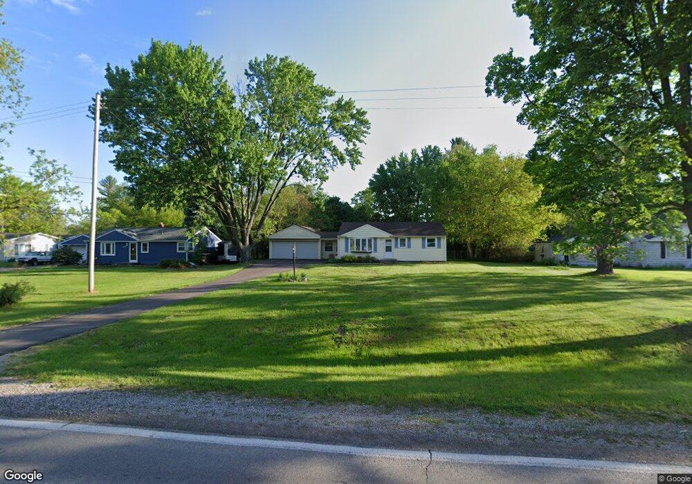
This home is located at 3368 W Wilson Rd, Clio, MI 48420 and is currently estimated at $172,132, approximately $167 per square foot. 3368 W Wilson Rd is a home located in Genesee County with nearby schools including George R. Carter Middle School and Clio Area High School.
Ownership History
Date
Name
Owned For
Owner Type
Purchase Details
Closed on
Oct 23, 2025
Sold by
Vanlinden Teri D
Bought by
Vanlinden Teri D and Still Raymond M
Current Estimated Value
Purchase Details
Closed on
Feb 10, 2003
Sold by
Allen Darrell W and Allen Jeanna M
Bought by
Vanlinden Teri D
Home Financials for this Owner
Home Financials are based on the most recent Mortgage that was taken out on this home.
Original Mortgage
$106,400
Interest Rate
6.06%
Purchase Details
Closed on
Sep 4, 2001
Sold by
Sauve Gregory
Bought by
Allen Darrell W and Allen Jeanna M
Purchase Details
Closed on
Dec 14, 2000
Sold by
Peterie Gary and Peterie Helen K
Bought by
Sauve Gregory
Create a Home Valuation Report for This Property
The Home Valuation Report is an in-depth analysis detailing your home's value as well as a comparison with similar homes in the area
Home Values in the Area
Average Home Value in this Area
Purchase History
| Date | Buyer | Sale Price | Title Company |
|---|---|---|---|
| Vanlinden Teri D | -- | None Listed On Document | |
| Vanlinden Teri D | -- | None Listed On Document | |
| Vanlinden Teri D | $112,000 | Greco Title | |
| Allen Darrell W | $90,000 | Guaranty Title Company | |
| Sauve Gregory | $98,500 | Guaranty Title Company |
Source: Public Records
Mortgage History
| Date | Status | Borrower | Loan Amount |
|---|---|---|---|
| Previous Owner | Vanlinden Teri D | $106,400 |
Source: Public Records
Tax History
| Year | Tax Paid | Tax Assessment Tax Assessment Total Assessment is a certain percentage of the fair market value that is determined by local assessors to be the total taxable value of land and additions on the property. | Land | Improvement |
|---|---|---|---|---|
| 2025 | $1,266 | $68,000 | $0 | $0 |
| 2024 | $496 | $60,400 | $0 | $0 |
| 2023 | $473 | $57,900 | $0 | $0 |
| 2022 | $1,110 | $52,100 | $0 | $0 |
| 2021 | $1,097 | $47,000 | $0 | $0 |
| 2020 | $433 | $43,700 | $0 | $0 |
| 2019 | $395 | $39,300 | $0 | $0 |
| 2018 | $958 | $34,100 | $0 | $0 |
| 2017 | $912 | $34,100 | $0 | $0 |
| 2016 | $905 | $28,400 | $0 | $0 |
| 2015 | $898 | $26,700 | $0 | $0 |
| 2012 | -- | $25,700 | $25,700 | $0 |
Source: Public Records
Map
Nearby Homes
- 11096 N Jennings Rd
- 11209 Phyllis Dr
- 11159 Pheasant Run Dr
- 3172 Quail Ridge Ct
- 3166 Quail Ridge Ct
- 11402 Hidden Oaks Dr Unit 41
- 11410 Hidden Oaks Dr
- 608 Stone Creek Pass Unit 14
- 11426 Hidden Oaks Dr
- 11430 Hidden Oaks Dr
- 4093 Libbie Dr
- 11434 Hidden Oaks Dr
- 11449 Hidden Oaks Dr
- 11453 Hidden Oaks Dr
- 11378 Runnells Dr
- 11457 Hidden Oaks Dr Unit 12
- 11461 Hidden Oaks Dr Unit 11
- 4500 W Wilson Rd
- 11470 Wing Dr
- 10190 Lavern Ct
- 3358 W Wilson Rd
- 3376 W Wilson Rd
- 3384 W Wilson Rd
- 11030 Phyllis Dr
- 11039 Bare Dr
- 3336 W Wilson Rd
- 11020 Bare Dr
- 11040 Phyllis Dr
- 3365 W Wilson Rd
- 3375 W Wilson Rd
- 11030 Bare Dr
- 3404 W Wilson Rd
- 3355 W Wilson Rd
- 3385 W Wilson Rd
- 11049 Bare Dr
- 11050 Phyllis Dr
- 11048 Bare Dr
- 11029 Phyllis Dr
- 3412 W Wilson Rd
- 11039 Phyllis Dr
Your Personal Tour Guide
Ask me questions while you tour the home.