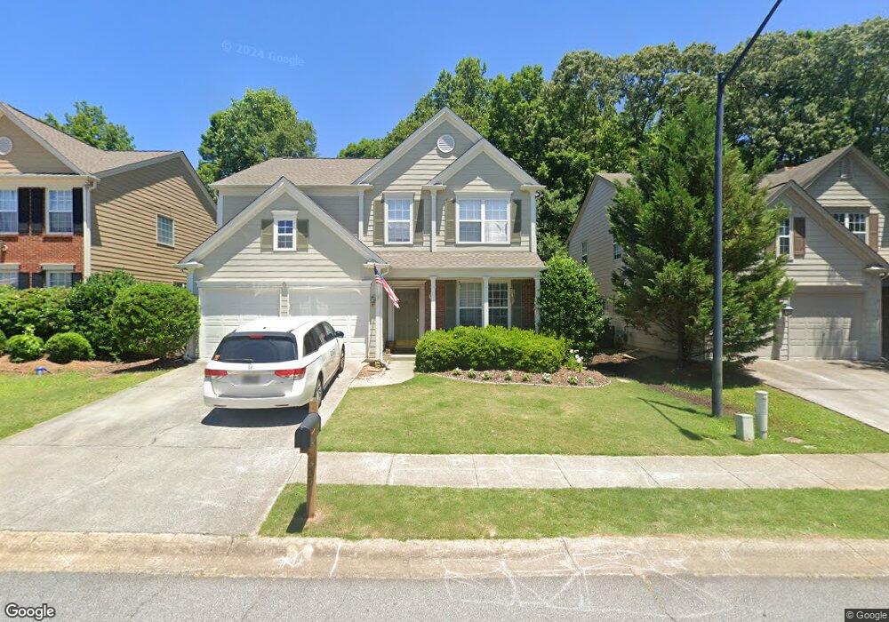
337 Burdock Trace Woodstock, GA 30188
Estimated Value: $455,075 - $466,000
3
Beds
3
Baths
1,986
Sq Ft
$232/Sq Ft
Est. Value
About This Home
This home is located at 337 Burdock Trace, Woodstock, GA 30188 and is currently estimated at $460,538, approximately $231 per square foot. 337 Burdock Trace is a home located in Cherokee County with nearby schools including Little River Elementary, Mill Creek Middle School, and River Ridge High School.
Ownership History
Date
Name
Owned For
Owner Type
Purchase Details
Closed on
Mar 20, 2015
Sold by
Ocm911 Llc
Bought by
337 Burdock Trace Llc
Current Estimated Value
Purchase Details
Closed on
Nov 19, 2003
Sold by
Pulte Homes Corp
Bought by
Mccann Andrew E
Home Financials for this Owner
Home Financials are based on the most recent Mortgage that was taken out on this home.
Original Mortgage
$144,448
Interest Rate
5.93%
Create a Home Valuation Report for This Property
The Home Valuation Report is an in-depth analysis detailing your home's value as well as a comparison with similar homes in the area
Home Values in the Area
Average Home Value in this Area
Purchase History
| Date | Buyer | Sale Price | Title Company |
|---|---|---|---|
| 337 Burdock Trace Llc | -- | -- | |
| Mccann Andrew E | $180,600 | -- |
Source: Public Records
Mortgage History
| Date | Status | Borrower | Loan Amount |
|---|---|---|---|
| Previous Owner | Mccann Andrew E | $144,448 |
Source: Public Records
Tax History Compared to Growth
Tax History
| Year | Tax Paid | Tax Assessment Tax Assessment Total Assessment is a certain percentage of the fair market value that is determined by local assessors to be the total taxable value of land and additions on the property. | Land | Improvement |
|---|---|---|---|---|
| 2025 | $5,001 | $174,884 | $34,800 | $140,084 |
| 2024 | $4,931 | $173,944 | $34,800 | $139,144 |
| 2023 | $865 | $158,488 | $33,200 | $125,288 |
| 2022 | $3,796 | $129,188 | $27,200 | $101,988 |
| 2021 | $2,796 | $111,128 | $22,000 | $89,128 |
| 2020 | $3,281 | $102,792 | $20,000 | $82,792 |
| 2019 | $2,348 | $93,360 | $20,000 | $73,360 |
| 2018 | $2,237 | $88,360 | $17,600 | $70,760 |
| 2017 | $2,207 | $216,300 | $17,600 | $68,920 |
| 2016 | $2,067 | $200,800 | $16,800 | $63,520 |
| 2015 | $2,016 | $194,100 | $15,200 | $62,440 |
| 2014 | $1,837 | $176,500 | $14,000 | $56,600 |
Source: Public Records
Map
Nearby Homes
- 321 Burdock Trace
- 236 Persimmon Dr
- 522 Watercress Dr
- 124 Riverside Ln
- 809 Araya Ct
- 116 Neetle Close Dr
- 202 Little River Way
- 414 Spring View Dr
- 133 Finsbury Ln
- 154 Towey Trail
- 144 Towey Trail
- 202 Kigian Trail
- 237 Kigian Trail
- 230 Apple Branch Dr
- 205 Deerchase Dr
- 939 Bendleton Dr
- 140 Apple Valley Dr
- 212 Regent Square
- 339 Burdock Trace
- 335 Burdock Trace
- 341 Burdock Trace
- 333 Burdock Trace
- 343 Burdock Trace
- 331 Burdock Trace Unit 331
- 331 Burdock Trace
- 300 Melilot Ct
- 330 Burdock Trace
- 328 Burdock Trace
- 345 Burdock Trace
- 329 Burdock Trace
- 0 Melilot Ct Unit 7298155
- 326 Burdock Trace
- 334 Burdock Trace
- 347 Burdock Trace
- 327 Burdock Trace
- 324 Burdock Trace
- 0 Burdock Trace
- 336 Burdock Trace