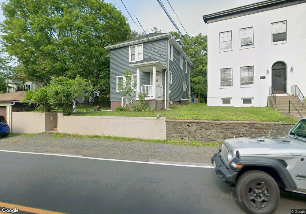
337 Route 340 Sparkill, NY 10976
Estimated Value: $600,399 - $620,000
2
Beds
3
Baths
1,200
Sq Ft
$510/Sq Ft
Est. Value
About This Home
This home is located at 337 Route 340, Sparkill, NY 10976 and is currently estimated at $611,850, approximately $509 per square foot. 337 Route 340 is a home located in Rockland County with nearby schools including William O Schaefer Elementary School, Cottage Lane Elementary School, and South Orangetown Middle School.
Ownership History
Date
Name
Owned For
Owner Type
Purchase Details
Closed on
Jan 13, 2020
Sold by
Logerfo Matthew and Nicholl Jane
Bought by
Clark Bridget F and Clark Jonathan F
Current Estimated Value
Home Financials for this Owner
Home Financials are based on the most recent Mortgage that was taken out on this home.
Original Mortgage
$380,000
Outstanding Balance
$336,391
Interest Rate
3.7%
Mortgage Type
New Conventional
Estimated Equity
$275,459
Purchase Details
Closed on
Jun 16, 2005
Sold by
Fatale Anthony W
Bought by
Logerfo Matthew and Colterjohn Jane
Home Financials for this Owner
Home Financials are based on the most recent Mortgage that was taken out on this home.
Original Mortgage
$324,000
Interest Rate
5.78%
Mortgage Type
Fannie Mae Freddie Mac
Purchase Details
Closed on
Mar 25, 2004
Sold by
Benicasa Angelina
Bought by
Fatale Anthony W
Create a Home Valuation Report for This Property
The Home Valuation Report is an in-depth analysis detailing your home's value as well as a comparison with similar homes in the area
Home Values in the Area
Average Home Value in this Area
Purchase History
| Date | Buyer | Sale Price | Title Company |
|---|---|---|---|
| Clark Bridget F | $400,000 | Chicago Title | |
| Logerfo Matthew | $405,000 | The Judicial Title Ins Agenc | |
| Fatale Anthony W | $300,000 | -- |
Source: Public Records
Mortgage History
| Date | Status | Borrower | Loan Amount |
|---|---|---|---|
| Open | Clark Bridget F | $380,000 | |
| Previous Owner | Logerfo Matthew | $324,000 | |
| Closed | Logerfo Matthew | $60,750 |
Source: Public Records
Tax History Compared to Growth
Tax History
| Year | Tax Paid | Tax Assessment Tax Assessment Total Assessment is a certain percentage of the fair market value that is determined by local assessors to be the total taxable value of land and additions on the property. | Land | Improvement |
|---|---|---|---|---|
| 2024 | $11,610 | $148,400 | $21,300 | $127,100 |
| 2023 | $11,610 | $148,400 | $21,300 | $127,100 |
| 2022 | $9,194 | $148,400 | $21,300 | $127,100 |
| 2021 | $9,194 | $148,400 | $21,300 | $127,100 |
| 2020 | $9,189 | $148,400 | $21,300 | $127,100 |
| 2019 | $8,559 | $148,400 | $21,300 | $127,100 |
| 2018 | $8,559 | $148,400 | $21,300 | $127,100 |
| 2017 | $8,246 | $148,400 | $21,300 | $127,100 |
| 2016 | $7,999 | $148,400 | $21,300 | $127,100 |
| 2015 | -- | $148,400 | $21,300 | $127,100 |
| 2014 | -- | $148,400 | $21,300 | $127,100 |
Source: Public Records
Map
Nearby Homes
- 3 W Lawrence Park Dr Unit 1
- 1 W Lawrence Park Dr Unit 10
- 8 Haring Ave
- 210 Ferdon Ave
- 414 Kings Hwy
- 4 Deer Run
- 450 Valentine Ave
- 26 Van Terrace
- 272 Piermont Ave
- 613 Route 9w
- 199 Tweed Blvd
- 52 Broadway
- 201 Tweed Blvd
- 21 Hartz Terrace
- 75 Tate Ave
- 13 Ash St
- 50 Franklin St
- 44-46 Kinney St
- 563 Piermont Ave
- 99 Paradise Ave