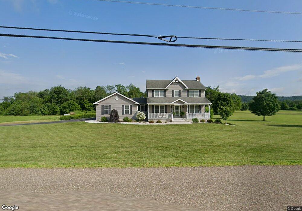
3373 Ridge Rd Bloomsburg, PA 17815
Estimated Value: $348,000 - $441,000
--
Bed
--
Bath
2,194
Sq Ft
$182/Sq Ft
Est. Value
About This Home
This home is located at 3373 Ridge Rd, Bloomsburg, PA 17815 and is currently estimated at $399,254, approximately $181 per square foot. 3373 Ridge Rd is a home located in Columbia County with nearby schools including Central Columbia Elementary School, Central Columbia Middle School, and Central Columbia Senior High School.
Ownership History
Date
Name
Owned For
Owner Type
Purchase Details
Closed on
Aug 10, 2019
Sold by
Ibrahim Ghassan T and Ibrahim Suhair Y
Bought by
Toblas Christopher R and Toblas Alissa R
Current Estimated Value
Home Financials for this Owner
Home Financials are based on the most recent Mortgage that was taken out on this home.
Original Mortgage
$279,538
Outstanding Balance
$244,824
Interest Rate
3.7%
Mortgage Type
New Conventional
Estimated Equity
$154,430
Purchase Details
Closed on
Jul 23, 2009
Sold by
Switzer Stephen and Switzer Susan
Bought by
Ibrahim Ghassan T and Ibrahim Suhair V
Home Financials for this Owner
Home Financials are based on the most recent Mortgage that was taken out on this home.
Original Mortgage
$205,600
Interest Rate
5.58%
Mortgage Type
New Conventional
Create a Home Valuation Report for This Property
The Home Valuation Report is an in-depth analysis detailing your home's value as well as a comparison with similar homes in the area
Home Values in the Area
Average Home Value in this Area
Purchase History
| Date | Buyer | Sale Price | Title Company |
|---|---|---|---|
| Toblas Christopher R | $294,250 | Box Multi Cnty Land Abstract | |
| Ibrahim Ghassan T | $257,000 | None Available |
Source: Public Records
Mortgage History
| Date | Status | Borrower | Loan Amount |
|---|---|---|---|
| Open | Toblas Christopher R | $279,538 | |
| Previous Owner | Ibrahim Ghassan T | $205,600 |
Source: Public Records
Tax History Compared to Growth
Tax History
| Year | Tax Paid | Tax Assessment Tax Assessment Total Assessment is a certain percentage of the fair market value that is determined by local assessors to be the total taxable value of land and additions on the property. | Land | Improvement |
|---|---|---|---|---|
| 2025 | $4,103 | $56,115 | $0 | $0 |
| 2024 | $4,007 | $56,115 | $5,485 | $50,630 |
| 2023 | $3,839 | $56,115 | $5,485 | $50,630 |
| 2022 | $3,783 | $56,115 | $5,485 | $50,630 |
| 2021 | $3,783 | $56,115 | $5,485 | $50,630 |
| 2020 | $3,661 | $56,115 | $5,485 | $50,630 |
| 2019 | $3,591 | $56,115 | $5,485 | $50,630 |
| 2018 | $3,591 | $56,115 | $5,485 | $50,630 |
| 2017 | $3,534 | $56,115 | $5,485 | $50,630 |
| 2016 | -- | $56,115 | $5,485 | $50,630 |
| 2015 | -- | $56,115 | $5,485 | $50,630 |
| 2014 | -- | $51,532 | $5,485 | $46,047 |
Source: Public Records
Map
Nearby Homes
- 238 Horse Farm Rd
- 1308 Grandview Rd
- 0 Beilys Rd
- LOT #3 Sawmill Rd
- 63 Brentwood Cir
- 34 Fowlersville Rd
- 14 Fowlersville Rd
- 135 Ash St
- 107 E Pebble Ln
- 21 Levi St
- 139 Rotary St
- 3664 Red Maple Ln
- 0 Alliance Park Dr
- 252 McGuire Park Dr
- 17 Central Ave
- 4119 Old Berwick Rd
- 2882 Lackawanna Ave
- 0 Alliance Park Lot 6 Dr
- 9 Crestmont Cir
- 12 Ridge Crest Dr