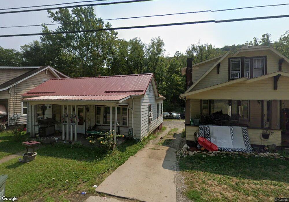
338 State Route 151 Mingo Junction, OH 43938
Estimated Value: $43,000 - $53,000
2
Beds
1
Bath
968
Sq Ft
$51/Sq Ft
Est. Value
About This Home
This home is located at 338 State Route 151, Mingo Junction, OH 43938 and is currently estimated at $49,272, approximately $50 per square foot. 338 State Route 151 is a home located in Jefferson County with nearby schools including Hills Elementary School, Indian Creek Middle School, and Indian Creek High School.
Ownership History
Date
Name
Owned For
Owner Type
Purchase Details
Closed on
Dec 8, 2022
Sold by
Ware Donald M and Ware Diana L
Bought by
Lott Christopher J
Current Estimated Value
Home Financials for this Owner
Home Financials are based on the most recent Mortgage that was taken out on this home.
Original Mortgage
$35,000
Outstanding Balance
$27,650
Interest Rate
6.95%
Mortgage Type
New Conventional
Estimated Equity
$21,622
Purchase Details
Closed on
Dec 20, 2021
Sold by
Ware Donald M and Ware Ida M
Bought by
Ware Donald M and Ware David A
Purchase Details
Closed on
Jan 6, 2017
Sold by
Gardner Thomas William and Gardner Janice Lee
Bought by
Ware Donald M and Ware Donald
Purchase Details
Closed on
Jul 23, 2014
Sold by
Janice Lee Janice Lee
Bought by
Gardner Thomas William and Gardner Janice Lee
Create a Home Valuation Report for This Property
The Home Valuation Report is an in-depth analysis detailing your home's value as well as a comparison with similar homes in the area
Home Values in the Area
Average Home Value in this Area
Purchase History
| Date | Buyer | Sale Price | Title Company |
|---|---|---|---|
| Lott Christopher J | $35,000 | -- | |
| Ware Donald M | -- | None Available | |
| Ware Donald M | $9,000 | None Available | |
| Gardner Thomas William | -- | -- |
Source: Public Records
Mortgage History
| Date | Status | Borrower | Loan Amount |
|---|---|---|---|
| Open | Lott Christopher J | $35,000 |
Source: Public Records
Tax History
| Year | Tax Paid | Tax Assessment Tax Assessment Total Assessment is a certain percentage of the fair market value that is determined by local assessors to be the total taxable value of land and additions on the property. | Land | Improvement |
|---|---|---|---|---|
| 2024 | $722 | $8,061 | $1,519 | $6,542 |
| 2023 | $713 | $6,777 | $1,369 | $5,408 |
| 2022 | $289 | $6,777 | $1,369 | $5,408 |
| 2021 | $289 | $6,777 | $1,369 | $5,408 |
| 2020 | $291 | $6,867 | $1,596 | $5,271 |
| 2019 | $294 | $0 | $0 | $0 |
| 2018 | $289 | $0 | $0 | $0 |
| 2017 | $330 | $0 | $0 | $0 |
| 2016 | $360 | $0 | $0 | $0 |
| 2015 | $360 | $0 | $0 | $0 |
| 2014 | $387 | $0 | $0 | $0 |
| 2012 | $188 | $10,115 | $1,400 | $8,715 |
Source: Public Records
Map
Nearby Homes
- 87R 26th St
- 2200 Main St
- 1922 Marianna St
- 316 Churchway St
- 124 Peeler St
- 2023 Commerce St
- 116 Benita Dr
- 134 Spring Ave
- 100 17th St
- 118 Spring Ave
- 1615 Charles St
- 1512 Main St
- 355 Lincoln Ave
- 116 McLister Ave
- 141 West Blvd
- 305 Grandview Ave
- 224 Shamrock Ave
- 1248 County Road 19
- 1213 Rabbit Hill Rd
- 1315 Charles St
- 338 Ohio 151
- 338 Smithfield St
- 324 State Route 151
- 324 State Route 151
- 324 State Route 151
- 324 State Route 151
- 362 State Route 151
- 318 State Route 151
- 312 State Route 151
- 347 State Route 151
- 359 Ohio 151
- 329 State Route 151
- 359 State Route 151
- 309 Smithfield St
- 375 State Route 151
- 396 State Route 151
- 305 Smithfield St
- 115 Emery Ave
- 119 Emery Ave
- 111 Emery Ave
Your Personal Tour Guide
Ask me questions while you tour the home.