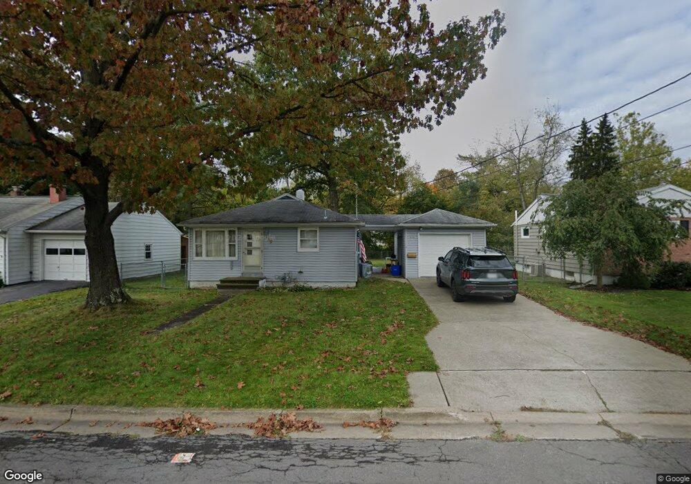
339 Doyleson Ave Endicott, NY 13760
Estimated Value: $122,000 - $203,000
3
Beds
1
Bath
936
Sq Ft
$168/Sq Ft
Est. Value
About This Home
This home is located at 339 Doyleson Ave, Endicott, NY 13760 and is currently estimated at $157,650, approximately $168 per square foot. 339 Doyleson Ave is a home located in Broome County with nearby schools including Maine-Endwell Senior High School, All Saints School, and All Saints.
Ownership History
Date
Name
Owned For
Owner Type
Purchase Details
Closed on
Dec 15, 2022
Sold by
Isabella Elaine A
Bought by
Johnston Donald H
Current Estimated Value
Home Financials for this Owner
Home Financials are based on the most recent Mortgage that was taken out on this home.
Original Mortgage
$50,000
Outstanding Balance
$43,975
Interest Rate
6.29%
Mortgage Type
New Conventional
Estimated Equity
$113,675
Purchase Details
Closed on
Apr 12, 2010
Sold by
Cary Mary R
Bought by
Cary Mary R and Isabella Elaine A
Create a Home Valuation Report for This Property
The Home Valuation Report is an in-depth analysis detailing your home's value as well as a comparison with similar homes in the area
Home Values in the Area
Average Home Value in this Area
Purchase History
| Date | Buyer | Sale Price | Title Company |
|---|---|---|---|
| Johnston Donald H | $83,000 | None Available | |
| Cary Mary R | -- | None Available |
Source: Public Records
Mortgage History
| Date | Status | Borrower | Loan Amount |
|---|---|---|---|
| Open | Johnston Donald H | $50,000 |
Source: Public Records
Tax History
| Year | Tax Paid | Tax Assessment Tax Assessment Total Assessment is a certain percentage of the fair market value that is determined by local assessors to be the total taxable value of land and additions on the property. | Land | Improvement |
|---|---|---|---|---|
| 2024 | $3,588 | $3,400 | $350 | $3,050 |
| 2023 | $3,539 | $3,400 | $350 | $3,050 |
| 2022 | $3,582 | $3,400 | $350 | $3,050 |
| 2021 | $3,539 | $3,400 | $350 | $3,050 |
| 2020 | $1,379 | $3,400 | $350 | $3,050 |
| 2019 | $0 | $3,400 | $350 | $3,050 |
| 2018 | $1,315 | $3,400 | $350 | $3,050 |
| 2017 | $1,296 | $3,400 | $350 | $3,050 |
| 2016 | $1,286 | $3,400 | $350 | $3,050 |
| 2015 | -- | $3,400 | $350 | $3,050 |
| 2014 | -- | $3,400 | $350 | $3,050 |
Source: Public Records
Map
Nearby Homes
- 315 Norton Ave
- 12 Paynter Ave
- 3617 Lott St
- 502 Winston Dr
- 3013 Robins St
- 515 Lowell Dr
- 3638 Hoover Ave
- 30 N Avenue B
- 52 Lee Ave
- 2823 Yale St
- 2829 Country Club Rd
- 3635 Leonard Dr
- 3819 Country Club Rd
- 228 Hastings Ave
- 3102 Buckingham Rd
- 222 Harding Ave
- 625 Valleyview Dr
- 3613 Alameda Ln
- 2714 Magnolia St
- 3741 River Rd
- 337 Doyleson Ave
- 341 Doyleson Ave
- 343 Doyleson Ave
- 335 Doyleson Ave
- 333 Doyleson Ave
- 345 Doyleson Ave
- 338 Doyleson Ave
- 340 Doyleson Ave
- 336 Doyleson Ave
- 326 Norton Ave
- 324 Norton Ave
- 342 Doyleson Ave
- 328 Norton Ave
- 334 Doyleson Ave
- 322 Norton Ave
- 331 Doyleson Ave
- 347 Doyleson Ave
- 344 Doyleson Ave
- 330 Norton Ave
- 320 Norton Ave
Your Personal Tour Guide
Ask me questions while you tour the home.