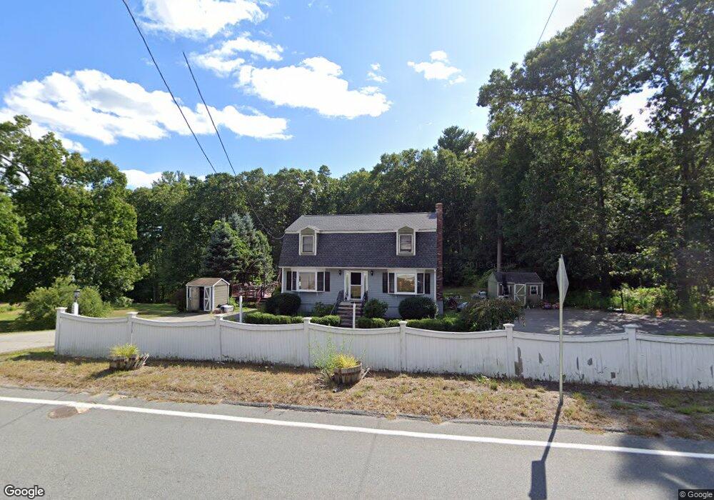
339 Hampshire Rd Methuen, MA 01844
The West End NeighborhoodEstimated Value: $700,000 - $789,000
3
Beds
3
Baths
2,496
Sq Ft
$304/Sq Ft
Est. Value
About This Home
This home is located at 339 Hampshire Rd, Methuen, MA 01844 and is currently estimated at $759,719, approximately $304 per square foot. 339 Hampshire Rd is a home located in Essex County with nearby schools including Marsh Grammar School, Methuen High School, and The Birches Academy of Academics and Art.
Ownership History
Date
Name
Owned For
Owner Type
Purchase Details
Closed on
Sep 1, 2000
Sold by
Thornhill Michael L
Bought by
Lavin Brian S and Lavin Kimberly J
Current Estimated Value
Purchase Details
Closed on
Dec 4, 1991
Sold by
Eastern Bank
Bought by
Thornhill Michael L
Create a Home Valuation Report for This Property
The Home Valuation Report is an in-depth analysis detailing your home's value as well as a comparison with similar homes in the area
Home Values in the Area
Average Home Value in this Area
Purchase History
| Date | Buyer | Sale Price | Title Company |
|---|---|---|---|
| Lavin Brian S | $230,000 | -- | |
| Thornhill Michael L | $129,000 | -- |
Source: Public Records
Mortgage History
| Date | Status | Borrower | Loan Amount |
|---|---|---|---|
| Open | Thornhill Michael L | $232,000 | |
| Closed | Thornhill Michael L | $212,500 |
Source: Public Records
Tax History Compared to Growth
Tax History
| Year | Tax Paid | Tax Assessment Tax Assessment Total Assessment is a certain percentage of the fair market value that is determined by local assessors to be the total taxable value of land and additions on the property. | Land | Improvement |
|---|---|---|---|---|
| 2025 | $7,137 | $674,600 | $283,900 | $390,700 |
| 2024 | $6,845 | $630,300 | $248,500 | $381,800 |
| 2023 | $6,476 | $553,500 | $218,800 | $334,700 |
| 2022 | $5,957 | $456,500 | $179,500 | $277,000 |
| 2021 | $5,763 | $436,900 | $169,600 | $267,300 |
| 2020 | $5,587 | $415,700 | $169,600 | $246,100 |
| 2019 | $5,352 | $377,200 | $159,800 | $217,400 |
| 2018 | $5,027 | $352,300 | $150,000 | $202,300 |
| 2017 | $5,050 | $344,700 | $150,000 | $194,700 |
| 2016 | $4,847 | $327,300 | $140,100 | $187,200 |
Source: Public Records
Map
Nearby Homes
- 13 Silver Brook Rd
- 131 Bridle Path Ln
- 96 Harris St
- 39 Ticklefancy Ln
- 11 Surrey Ln
- 25 Marie Ave
- 272 Pelham St
- 42 Brentwood Rd
- 23 Harvard Ave
- 20 Canobieola Rd
- 7 Jade St
- 221 Pelham St
- 3 Kennedy Dr
- 280 & 290 Spring Rd
- 10 Dunrobin Cir
- 10 Dunrobin Cir Unit 10
- 13 Hastings Cir
- 73 Myrtle St
- 386 Forest St
- 12 Ballard Rd
- 343 Hampshire Rd
- 335 Hampshire Rd
- 345 Hampshire Rd
- 342 Hampshire Rd
- 344 Hampshire Rd
- 334 Hampshire Rd
- 347 Hampshire Rd
- 336 Hampshire Rd
- 331 Hampshire Rd
- 423 Pelham St
- 415 Pelham St
- 350 Hampshire Rd
- 330 Hampshire Rd
- 327 Hampshire Rd
- 346 Hampshire Rd
- 338 Hampshire Rd
- 426 Pelham St
- 340 Hampshire Rd
- 428 Pelham St
- 430 Pelham St