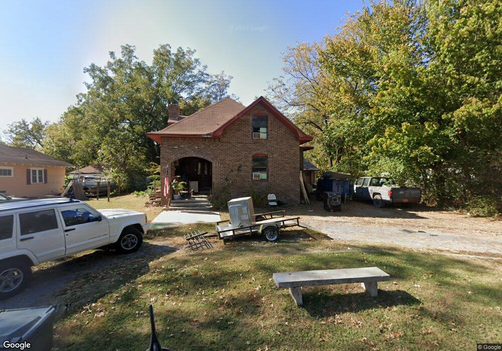
339 S 23rd St Muskogee, OK 74401
Central Muskogee NeighborhoodEstimated Value: $63,000 - $109,156
3
Beds
3
Baths
1,536
Sq Ft
$55/Sq Ft
Est. Value
About This Home
This home is located at 339 S 23rd St, Muskogee, OK 74401 and is currently estimated at $85,039, approximately $55 per square foot. 339 S 23rd St is a home located in Muskogee County with nearby schools including Cherokee Elementary School, 8th & 9th Grade Academy @ Alice Robertson, and Muskogee High School.
Ownership History
Date
Name
Owned For
Owner Type
Purchase Details
Closed on
May 27, 2009
Sold by
Crane Michael and Crane Lisa M
Bought by
Fort Christopher and Fort Lauren
Current Estimated Value
Home Financials for this Owner
Home Financials are based on the most recent Mortgage that was taken out on this home.
Original Mortgage
$37,000
Interest Rate
4.76%
Mortgage Type
Purchase Money Mortgage
Purchase Details
Closed on
Jul 2, 2008
Sold by
Cross Allyeen
Bought by
Crane Michael A and Crane Lisa M
Purchase Details
Closed on
May 15, 1997
Create a Home Valuation Report for This Property
The Home Valuation Report is an in-depth analysis detailing your home's value as well as a comparison with similar homes in the area
Home Values in the Area
Average Home Value in this Area
Purchase History
| Date | Buyer | Sale Price | Title Company |
|---|---|---|---|
| Fort Christopher | $37,000 | Muskogee Abstract & Title Co | |
| Crane Michael A | $27,500 | None Available | |
| -- | -- | -- |
Source: Public Records
Mortgage History
| Date | Status | Borrower | Loan Amount |
|---|---|---|---|
| Closed | Fort Christopher | $37,000 |
Source: Public Records
Tax History Compared to Growth
Tax History
| Year | Tax Paid | Tax Assessment Tax Assessment Total Assessment is a certain percentage of the fair market value that is determined by local assessors to be the total taxable value of land and additions on the property. | Land | Improvement |
|---|---|---|---|---|
| 2025 | $394 | $3,793 | $291 | $3,502 |
| 2024 | $394 | $3,612 | $277 | $3,335 |
| 2023 | $394 | $3,441 | $248 | $3,193 |
| 2022 | $343 | $3,441 | $248 | $3,193 |
| 2021 | $344 | $3,441 | $248 | $3,193 |
| 2020 | $345 | $3,441 | $248 | $3,193 |
| 2019 | $405 | $4,077 | $248 | $3,829 |
| 2018 | $398 | $4,077 | $248 | $3,829 |
| 2017 | $384 | $4,076 | $248 | $3,828 |
| 2016 | $389 | $4,076 | $248 | $3,828 |
| 2015 | $392 | $4,076 | $248 | $3,828 |
| 2014 | $1 | $4,076 | $248 | $3,828 |
Source: Public Records
Map
Nearby Homes
- 2122 Denver St
- 2106 Denver St
- 2116 Columbus Ave
- 2425 Columbus St
- 2402 Boston St
- 0 Columbus Ave
- 2111 Elgin St
- 2601 Boston St
- 2419 W Okmulgee St
- 1509 Columbus St
- 2618 Columbus St
- 2610 Elgin St
- 109 N 16th St
- 2612 W Broadway St
- 1313 Fremont St
- 0 N 23rd St
- 2805 W Okmulgee St
- 2411 Pine St
- 415 S 13th St
- 233 S 13th St
- 2314 Denver St
- 343 S 23rd St
- 2307 Garland St
- 2305 Garland St
- 2309 Garland St
- 2303 Garland St
- 2316 Denver St
- 2319 Garland St
- 2321 Garland St
- 2320 Denver St
- 2129 Garland St
- 2318 Denver St
- 2130 Denver St
- 2319 Denver St
- 2321 Denver St
- 2303 Denver St
- 2315 Denver St
- 2300 Garland St
- 2301 Denver St
- 2323 Garland St