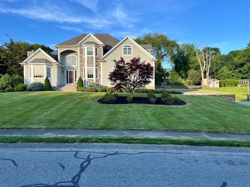


34 Base Lodge Ln Swansea, MA 02777
Northeast Swansea NeighborhoodEstimated payment $5,581/month
Highlights
- Above Ground Pool
- Cathedral Ceiling
- Attic
- Colonial Architecture
- Wood Flooring
- 2 Fireplaces
About This Home
Welcome home to 34 Base Lodge Lane. Once you step foot onto this property, you may never want to leave - this house has it all! Located just minutes away from highways, retail stores, grocery stores, gas stations, restaurants, and all 3 schools, yet secluded in a beautiful, quiet, friendly, and well-established neighborhood, you couldn't ask for a better location. From the open-concept layout, to the cathedral ceilings, to the private home office, to the oversized 22x23 bonus room, to the master bedroom balcony that overlooks the backyard, to so much more - I'm not sure what the best feature is! Also, with outdoor features like a well-maintained, large yard, a basketball hoop, an above-ground pool, and a patio, you have no reason to leave (unless you want to). This is a home that you just have to come see for yourself to appreciate all it has to offer.
Home Details
Home Type
- Single Family
Est. Annual Taxes
- $9,532
Year Built
- Built in 2005
Lot Details
- 0.8 Acre Lot
- Sprinkler System
- Cleared Lot
- Property is zoned R1
Parking
- 2 Car Attached Garage
Home Design
- Colonial Architecture
- Blown Fiberglass Insulation
- Concrete Perimeter Foundation
Interior Spaces
- 3,313 Sq Ft Home
- Wet Bar
- Central Vacuum
- Wired For Sound
- Cathedral Ceiling
- Decorative Lighting
- 2 Fireplaces
- French Doors
- Sitting Room
- Home Office
- Play Room
- Basement Fills Entire Space Under The House
- Attic
Kitchen
- Oven
- Range
- Microwave
- Dishwasher
Flooring
- Wood
- Tile
Bedrooms and Bathrooms
- 3 Bedrooms
- Primary bedroom located on second floor
Laundry
- Laundry on main level
- Washer and Gas Dryer Hookup
Home Security
- Home Security System
- Intercom
Outdoor Features
- Above Ground Pool
- Patio
Utilities
- Central Air
- 2 Cooling Zones
- 2 Heating Zones
- Hydro-Air Heating System
- Generator Hookup
- 220 Volts
- 200+ Amp Service
- Power Generator
- Private Water Source
- Gas Water Heater
- Private Sewer
Community Details
- No Home Owners Association
Listing and Financial Details
- Assessor Parcel Number 4025710
Map
Home Values in the Area
Average Home Value in this Area
Tax History
| Year | Tax Paid | Tax Assessment Tax Assessment Total Assessment is a certain percentage of the fair market value that is determined by local assessors to be the total taxable value of land and additions on the property. | Land | Improvement |
|---|---|---|---|---|
| 2025 | $10,156 | $852,000 | $221,000 | $631,000 |
| 2024 | $9,532 | $795,000 | $221,000 | $574,000 |
| 2023 | $8,491 | $646,700 | $161,800 | $484,900 |
| 2022 | $7,676 | $533,400 | $135,400 | $398,000 |
| 2021 | $7,052 | $451,200 | $139,000 | $312,200 |
| 2020 | $7,171 | $460,300 | $141,300 | $319,000 |
| 2019 | $7,234 | $466,400 | $128,300 | $338,100 |
| 2018 | $7,084 | $463,600 | $129,300 | $334,300 |
| 2017 | $6,173 | $464,800 | $134,400 | $330,400 |
| 2016 | $5,822 | $430,600 | $109,700 | $320,900 |
| 2015 | $5,645 | $429,900 | $109,700 | $320,200 |
| 2014 | $5,201 | $405,100 | $109,700 | $295,400 |
Property History
| Date | Event | Price | List to Sale | Price per Sq Ft |
|---|---|---|---|---|
| 11/04/2025 11/04/25 | For Sale | $910,000 | -- | $275 / Sq Ft |
Purchase History
| Date | Type | Sale Price | Title Company |
|---|---|---|---|
| Deed | $94,900 | -- |
Mortgage History
| Date | Status | Loan Amount | Loan Type |
|---|---|---|---|
| Open | $95,000 | No Value Available | |
| Closed | $75,920 | Purchase Money Mortgage |
Source: MLS Property Information Network (MLS PIN)
MLS Number: 73451105
APN: SWAN-000720-000000-000019L
Disclaimer: Certain information contained herein is derived from information provided by parties other than Homes.com. All information provided is deemed reliable, but is not guaranteed to be accurate and should be independently verified.
![]() The property listing data and information, or the Images, set forth herein were provided to MLS Property Information Network, Inc. from third party sources, including sellers, lessors and public records, and were compiled by MLS Property Information Network, Inc. The property listing data and information, and the Images, are for the personal, non-commercial use of consumers having a good faith interest in purchasing or leasing listed properties of the type displayed to them and may not be used for any purpose other than to identify prospective properties which such consumers may have a good faith interest in purchasing or leasing. MLS Property Information Network, Inc. and its subscribers disclaim any and all representations and warranties as to the accuracy of the property listing data and information, or as to the accuracy of any of the Images, set forth herein.
The property listing data and information, or the Images, set forth herein were provided to MLS Property Information Network, Inc. from third party sources, including sellers, lessors and public records, and were compiled by MLS Property Information Network, Inc. The property listing data and information, and the Images, are for the personal, non-commercial use of consumers having a good faith interest in purchasing or leasing listed properties of the type displayed to them and may not be used for any purpose other than to identify prospective properties which such consumers may have a good faith interest in purchasing or leasing. MLS Property Information Network, Inc. and its subscribers disclaim any and all representations and warranties as to the accuracy of the property listing data and information, or as to the accuracy of any of the Images, set forth herein.
- 24 Front St
- 8 2nd St
- 30 Front St
- 0 Hortonville Rd Unit 73242268
- 265 Stevens Rd
- 33 Rhinecliffe Rd
- 194 Hortonville Rd
- 675 Lees River Ave
- 197 Alberta Ave
- 19 Richard Rd
- 0 Bark St Unit 1342599
- 0 Bark St Unit 73152576
- Lot 11 Lynch
- 0 Proprietors Way Unit 73324662
- Lot 10 Lynch
- 58 Randall Ave
- 127 Sheraton Ave
- 60 Aetna St
- 196 Coolidge St
- 745 Bark St
- 297 Swansom Rd
- 76 Houlton St Unit 1
- 508 Grand Army of the Republic Highway St
- 108 Shawomet Ave Unit 3
- 53 Bowker Terrace Unit 2
- 55 Railroad Ave Unit 3
- 55 Railroad Ave
- 229 Oneil Rd Unit 1
- 74 Fulton St Unit 1W
- 32 Norfolk St Unit 1 E
- 1082 Davol St
- 112 Short St Unit 2 WEST
- 229 Brightman St Unit 2
- 269 Brightman St Unit 2
- 101 Cory St Unit 3
- 32 Oregon St Unit 32 Oregon st
- 88 Almy St Unit 2
- 322 Brownell St Unit 3W
- 122 Stowe St Unit 122
- 120 Stowe St Unit 120
