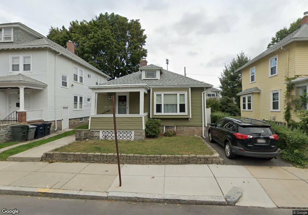
34 Bexley Rd Roslindale, MA 02131
Roslindale NeighborhoodEstimated Value: $537,000 - $732,000
2
Beds
2
Baths
988
Sq Ft
$652/Sq Ft
Est. Value
About This Home
This home is located at 34 Bexley Rd, Roslindale, MA 02131 and is currently estimated at $644,623, approximately $652 per square foot. 34 Bexley Rd is a home located in Suffolk County with nearby schools including Brooke Charter School Roslindale, Sacred Heart STEM School, and The Croft School - Jamaica Plain.
Ownership History
Date
Name
Owned For
Owner Type
Purchase Details
Closed on
Jan 27, 2000
Sold by
Bexley Road Rt
Bought by
White Joseph P and White Patricia H
Current Estimated Value
Home Financials for this Owner
Home Financials are based on the most recent Mortgage that was taken out on this home.
Original Mortgage
$112,500
Outstanding Balance
$36,293
Interest Rate
7.83%
Mortgage Type
Purchase Money Mortgage
Estimated Equity
$608,330
Create a Home Valuation Report for This Property
The Home Valuation Report is an in-depth analysis detailing your home's value as well as a comparison with similar homes in the area
Home Values in the Area
Average Home Value in this Area
Purchase History
| Date | Buyer | Sale Price | Title Company |
|---|---|---|---|
| White Joseph P | $125,000 | -- |
Source: Public Records
Mortgage History
| Date | Status | Borrower | Loan Amount |
|---|---|---|---|
| Open | White Joseph P | $112,500 |
Source: Public Records
Tax History
| Year | Tax Paid | Tax Assessment Tax Assessment Total Assessment is a certain percentage of the fair market value that is determined by local assessors to be the total taxable value of land and additions on the property. | Land | Improvement |
|---|---|---|---|---|
| 2025 | $6,962 | $601,200 | $202,700 | $398,500 |
| 2024 | $6,564 | $602,200 | $204,300 | $397,900 |
| 2023 | $6,042 | $562,600 | $190,900 | $371,700 |
| 2022 | $5,670 | $521,100 | $176,800 | $344,300 |
| 2021 | $5,171 | $484,600 | $170,000 | $314,600 |
| 2020 | $4,736 | $448,500 | $164,600 | $283,900 |
| 2019 | $4,507 | $427,600 | $132,900 | $294,700 |
| 2018 | $4,267 | $407,200 | $132,900 | $274,300 |
| 2017 | $4,069 | $384,200 | $132,900 | $251,300 |
| 2016 | $3,878 | $352,500 | $132,900 | $219,600 |
| 2015 | $3,879 | $320,300 | $128,400 | $191,900 |
| 2014 | $3,660 | $290,900 | $128,400 | $162,500 |
Source: Public Records
Map
Nearby Homes
- 132 Sycamore St
- 61 Fawndale Rd
- 626 South St
- 375 Hyde Park Ave Unit 3
- 23 Rowe St Unit 23 Rowe
- 19 Delford St
- 7 Basto Terrace
- 11 S Fairview St Unit 2R
- 472 Hyde Park Ave Unit 472
- 167 Poplar St Unit 1
- 46 Belgrade Ave Unit 2
- 18 Robert St Unit 4
- 18 Robert St Unit 14
- 68 Rowe St Unit 3
- 68 Rowe St Unit 2
- 4 Albano St Unit 2
- 543 Hyde Park Ave Unit 1
- 14 Whitford St
- 22 Walter St Unit 2
- 16 Hilburn Place
- 30 Bexley Rd
- 30 Bexley Rd Unit 1
- 36 Bexley Rd
- 28 Bexley Rd Unit 3
- 28 Bexley Rd Unit 2
- 28 Bexley Rd Unit 1
- 28 Bexley Rd Unit 2,28
- 38 Bexley Rd
- 28 Bexley Unit 1
- 33 Firth Rd
- 33 Firth Rd Unit 1
- 33 Firth Rd Unit 2
- 31 Firth Rd
- 35 Firth Rd
- 35 Firth Rd Unit 1
- 40 Bexley Rd
- 29 Firth Rd
- 24 Bexley Rd
- 24 Bexley Rd Unit 1
- 37 Firth Rd
Your Personal Tour Guide
Ask me questions while you tour the home.