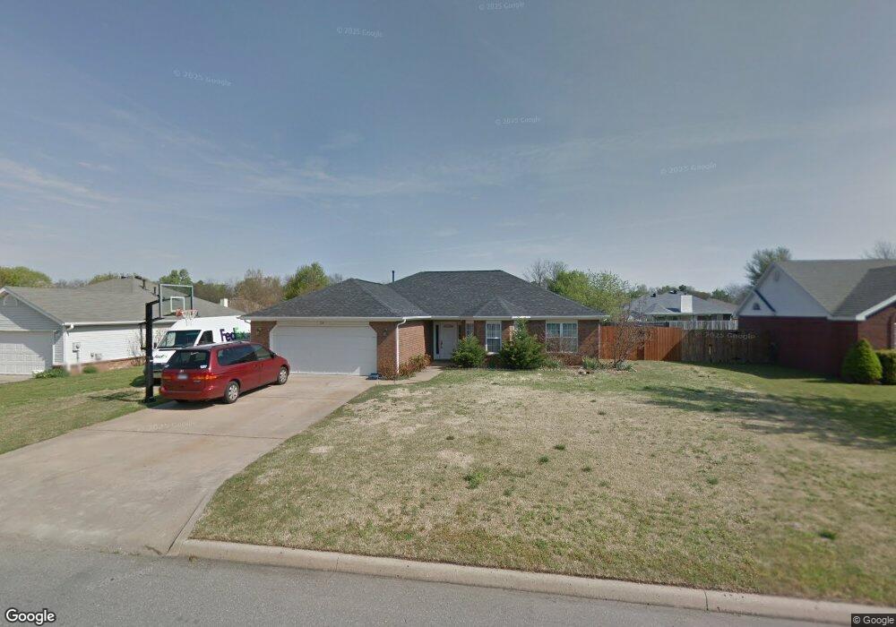
34 Briarmeadow St Farmington, AR 72730
Estimated Value: $275,070 - $300,000
--
Bed
2
Baths
1,512
Sq Ft
$190/Sq Ft
Est. Value
About This Home
This home is located at 34 Briarmeadow St, Farmington, AR 72730 and is currently estimated at $288,018, approximately $190 per square foot. 34 Briarmeadow St is a home located in Washington County with nearby schools including Randall G. Lynch Middle School, Bob Folsom Elementary School, and Farmington Jr. High.
Ownership History
Date
Name
Owned For
Owner Type
Purchase Details
Closed on
Oct 29, 1997
Bought by
Devecsery Daniel S and Devecsery Mattingly,
Current Estimated Value
Purchase Details
Closed on
Aug 6, 1997
Bought by
Devecsery Daniel
Purchase Details
Closed on
Sep 24, 1996
Bought by
Lossing John D
Purchase Details
Closed on
Feb 11, 1993
Bought by
Commercial Properties, Inc.
Create a Home Valuation Report for This Property
The Home Valuation Report is an in-depth analysis detailing your home's value as well as a comparison with similar homes in the area
Home Values in the Area
Average Home Value in this Area
Purchase History
| Date | Buyer | Sale Price | Title Company |
|---|---|---|---|
| Devecsery Daniel S | -- | -- | |
| Devecsery Daniel | $18,000 | -- | |
| Lossing John D | -- | -- | |
| Commercial Properties, Inc. | -- | -- |
Source: Public Records
Tax History Compared to Growth
Tax History
| Year | Tax Paid | Tax Assessment Tax Assessment Total Assessment is a certain percentage of the fair market value that is determined by local assessors to be the total taxable value of land and additions on the property. | Land | Improvement |
|---|---|---|---|---|
| 2025 | $1,150 | $50,960 | $9,000 | $41,960 |
| 2024 | $1,190 | $50,960 | $9,000 | $41,960 |
| 2023 | $1,257 | $50,960 | $9,000 | $41,960 |
| 2022 | $1,227 | $29,890 | $6,000 | $23,890 |
| 2021 | $1,236 | $29,890 | $6,000 | $23,890 |
| 2020 | $1,182 | $29,890 | $6,000 | $23,890 |
| 2019 | $1,114 | $27,520 | $6,000 | $21,520 |
| 2018 | $1,139 | $27,520 | $6,000 | $21,520 |
| 2017 | $1,125 | $27,520 | $6,000 | $21,520 |
| 2016 | $1,125 | $27,520 | $6,000 | $21,520 |
| 2015 | $1,125 | $27,520 | $6,000 | $21,520 |
| 2014 | $1,131 | $27,630 | $6,000 | $21,630 |
Source: Public Records
Map
Nearby Homes
- 93 Old Depot Rd
- 48 Cedar St
- 216 Idaho Ave
- 142 N Sheep Dog Ave
- 485 W Branta St
- TBD White St
- 271 Greenfield Ave
- 201 Countryside Dr
- 9 Bois d Arc St
- 237 Briarhill Dr
- 179 Birchfield Ln
- 311 S Sundown Dr
- 285 Briarhill Dr
- 114 W Main St
- 87 James St
- 103 Watson Ln
- 86 N Banner Ave
- 75 N Banner Ave
- 87 N Banner Ave
- Rye 1903 Plan at The Grove at Engles Mill
- 28 Briarmeadow St
- 22 Briarmeadow St
- 46 Briarmeadow St
- 35 Briarmeadow St
- 33 Northaven St
- 29 Briarmeadow St
- 27 Northaven St
- 41 Briarmeadow St
- 39 Northaven St
- 21 Northaven St
- 52 Briarmeadow St
- 23 Briarmeadow St
- 16 Briarmeadow St
- 47 Briarmeadow St
- 45 Northaven St
- 15 Northaven St
- 32 Northaven St
- 26 Northaven St
- 38 Northaven St
- 53 Briarmeadow St