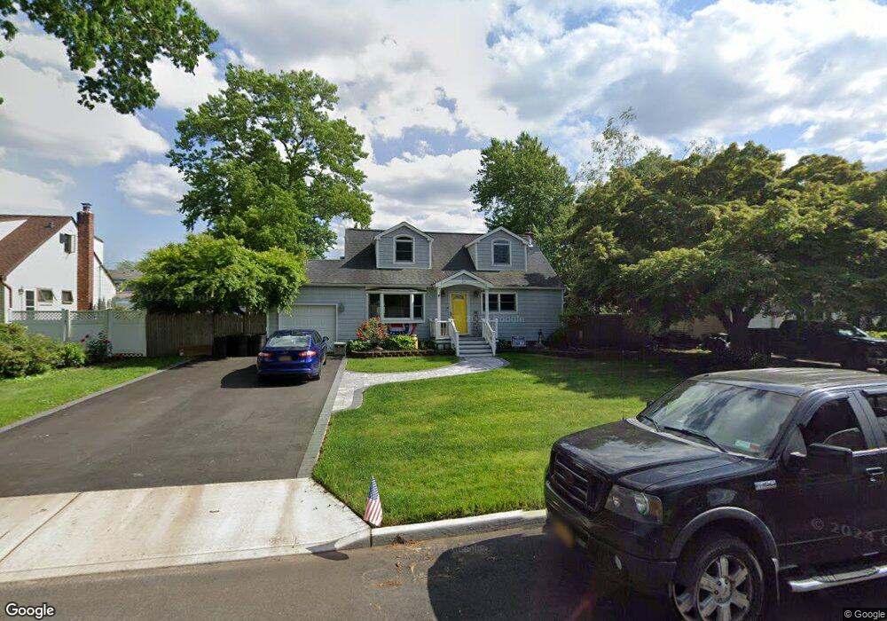
34 Briaroot Dr Smithtown, NY 11787
Estimated Value: $642,946 - $727,000
3
Beds
1
Bath
1,583
Sq Ft
$430/Sq Ft
Est. Value
About This Home
This home is located at 34 Briaroot Dr, Smithtown, NY 11787 and is currently estimated at $681,237, approximately $430 per square foot. 34 Briaroot Dr is a home located in Suffolk County with nearby schools including Mount Pleasant Elementary School, Smithtown Christian School, and St Patrick Elementary School.
Ownership History
Date
Name
Owned For
Owner Type
Purchase Details
Closed on
Apr 13, 2005
Sold by
May Michael A
Bought by
May Michael A
Current Estimated Value
Purchase Details
Closed on
Sep 22, 2003
Sold by
Mcnally Kevin J and Boyle Regina
Bought by
May Michael A and Oliveto Rosanne
Home Financials for this Owner
Home Financials are based on the most recent Mortgage that was taken out on this home.
Original Mortgage
$261,000
Interest Rate
6.43%
Mortgage Type
Purchase Money Mortgage
Purchase Details
Closed on
Sep 16, 2002
Sold by
Simmons Robert Y
Bought by
Mcnally Kevin J
Purchase Details
Closed on
Aug 30, 1995
Sold by
Mcnally Ulick J and Mcnally Florence A
Bought by
Mcnally Kevin J and Simmons Patricia
Create a Home Valuation Report for This Property
The Home Valuation Report is an in-depth analysis detailing your home's value as well as a comparison with similar homes in the area
Home Values in the Area
Average Home Value in this Area
Purchase History
| Date | Buyer | Sale Price | Title Company |
|---|---|---|---|
| May Michael A | -- | -- | |
| May Michael A | $290,000 | First American Title Ins Co | |
| Mcnally Kevin J | -- | -- | |
| Mcnally Kevin J | -- | First American Title Ins Co |
Source: Public Records
Mortgage History
| Date | Status | Borrower | Loan Amount |
|---|---|---|---|
| Previous Owner | May Michael A | $261,000 |
Source: Public Records
Tax History Compared to Growth
Tax History
| Year | Tax Paid | Tax Assessment Tax Assessment Total Assessment is a certain percentage of the fair market value that is determined by local assessors to be the total taxable value of land and additions on the property. | Land | Improvement |
|---|---|---|---|---|
| 2024 | $9,592 | $4,005 | $265 | $3,740 |
| 2023 | $9,592 | $4,005 | $265 | $3,740 |
| 2022 | $8,078 | $4,005 | $265 | $3,740 |
| 2021 | $8,078 | $4,005 | $265 | $3,740 |
| 2020 | $9,001 | $4,005 | $265 | $3,740 |
| 2019 | $9,001 | $0 | $0 | $0 |
| 2018 | -- | $4,005 | $265 | $3,740 |
| 2017 | $8,287 | $4,005 | $265 | $3,740 |
| 2016 | $8,198 | $4,005 | $265 | $3,740 |
| 2015 | -- | $4,005 | $265 | $3,740 |
| 2014 | -- | $3,705 | $265 | $3,440 |
Source: Public Records
Map
Nearby Homes
- 12 Wadsworth Place
- 25 Estate Rd
- 305 Devon Ln
- 365 Route 111 Unit A-4
- 365 Route 111 Unit C-4
- 22 5th Ave
- 58 Sherbrooke Dr
- 44 Apple Tree Dr
- 9 Graystone Ln
- 83 Sunrise Ln
- 206 Brooksite Dr
- 6 Keystone Ct
- 72 Mount Pleasant Rd
- 24 Sandra Dr
- 16 Wildwood Ln
- 5 Platt Ave
- 639 Townline Rd
- 41 W Pond Ct
- 32 Merrivale Dr
- 64 Brooksite Dr