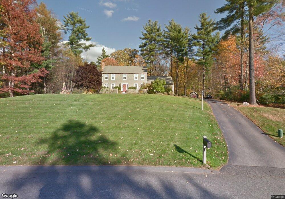
34 Connor Pass Uxbridge, MA 01569
Estimated Value: $603,000 - $743,000
4
Beds
3
Baths
1,888
Sq Ft
$355/Sq Ft
Est. Value
About This Home
This home is located at 34 Connor Pass, Uxbridge, MA 01569 and is currently estimated at $669,574, approximately $354 per square foot. 34 Connor Pass is a home located in Worcester County with nearby schools including Uxbridge High School, Our Lady of the Valley Regional School, and Whitinsville Christian School.
Ownership History
Date
Name
Owned For
Owner Type
Purchase Details
Closed on
Jul 12, 2001
Sold by
John W Audet Inc
Bought by
Cornell John J and Cornell Tara L
Current Estimated Value
Home Financials for this Owner
Home Financials are based on the most recent Mortgage that was taken out on this home.
Original Mortgage
$200,000
Interest Rate
7.2%
Mortgage Type
Purchase Money Mortgage
Create a Home Valuation Report for This Property
The Home Valuation Report is an in-depth analysis detailing your home's value as well as a comparison with similar homes in the area
Home Values in the Area
Average Home Value in this Area
Purchase History
| Date | Buyer | Sale Price | Title Company |
|---|---|---|---|
| Cornell John J | $266,560 | -- |
Source: Public Records
Mortgage History
| Date | Status | Borrower | Loan Amount |
|---|---|---|---|
| Open | Cornell John J | $110,500 | |
| Open | Cornell John J | $179,500 | |
| Closed | Cornell John J | $200,000 | |
| Closed | Cornell John J | $200,000 |
Source: Public Records
Tax History
| Year | Tax Paid | Tax Assessment Tax Assessment Total Assessment is a certain percentage of the fair market value that is determined by local assessors to be the total taxable value of land and additions on the property. | Land | Improvement |
|---|---|---|---|---|
| 2025 | $72 | $549,400 | $155,900 | $393,500 |
| 2024 | $6,835 | $529,000 | $148,100 | $380,900 |
| 2023 | $6,520 | $467,400 | $127,900 | $339,500 |
| 2022 | $5,900 | $389,200 | $112,200 | $277,000 |
| 2021 | $6,157 | $389,200 | $112,200 | $277,000 |
| 2020 | $6,082 | $363,300 | $118,000 | $245,300 |
| 2019 | $6,236 | $359,400 | $129,800 | $229,600 |
| 2018 | $6,080 | $354,100 | $129,800 | $224,300 |
| 2017 | $5,902 | $348,000 | $124,500 | $223,500 |
| 2016 | $5,656 | $321,900 | $95,300 | $226,600 |
| 2015 | $5,526 | $317,600 | $95,300 | $222,300 |
Source: Public Records
Map
Nearby Homes
- 25 Dunny Cove Ln
- 35 Pouts Ln
- 20 Nature View Dr Unit 20
- 24 Olde Canal Way Unit 24
- 27 Taft Ave
- 37 Elizabeth St
- 23 Uxbridge Rd
- 13A Asylum St
- 62 Millville Rd
- 19 Rawson Farm Rd
- 34 Rawson Farm Rd
- 4 Moon Hill Rd
- 3 Moon Hill Rd
- 50 Carrington Ln
- 14 Kelley Rd
- 13 Kelley Rd
- 53 Asylum St
- 185 Prairie St
- 4 Strathmore Shire Dr Unit B
- 3 Strathmore Shire Unit A
- 44 Connor Pass
- 24 Connor Pass
- 35 Connor Pass
- 55 Connor Pass
- 54 Connor Pass
- 5 Dunny Cove Rd
- 5 Dunny Cove Rd Unit 5
- 16 Dunny Cove Rd
- 19 Big Rock Rd
- 15 Dunny Cove Rd
- 20 Big Rock Rd
- 64 Connor Pass
- 65 Connor Pass
- 26 Dunny Cove Rd
- 663 E Hartford Ave
- 9 Big Rock Rd
- 635 Hartford Ave E
- 25 Dunny Cove Rd
- 671 Hartford Ave E
- 92 Rockmeadow Rd