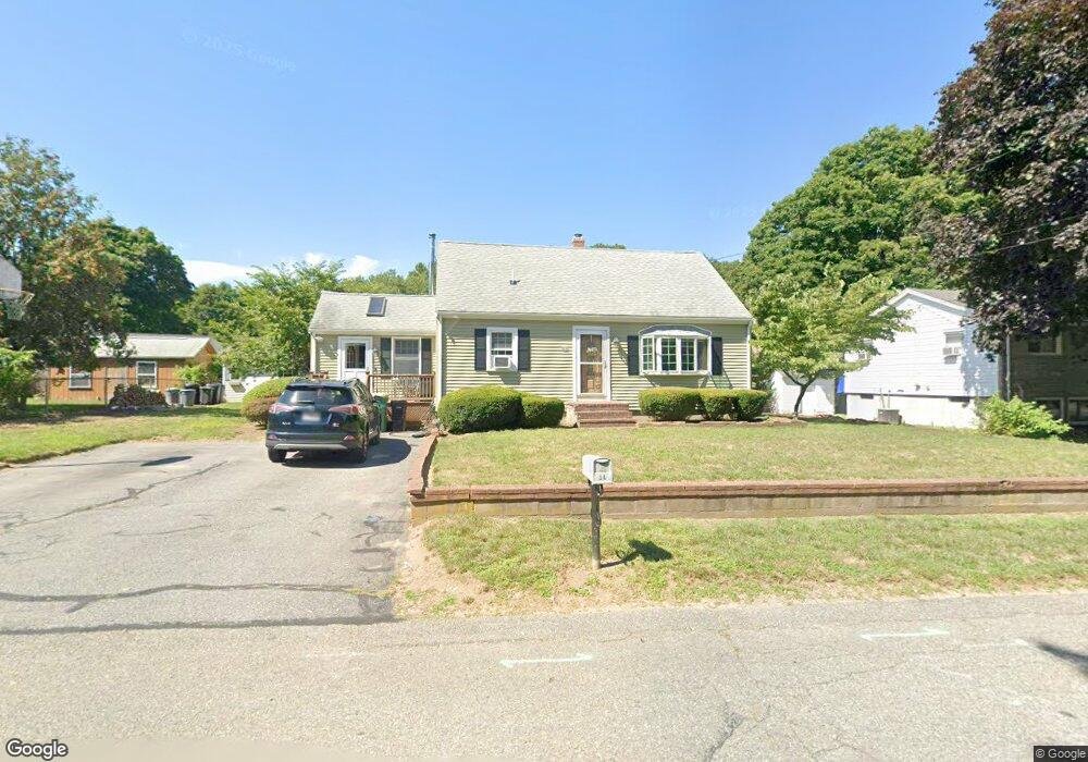
34 Donald Tennant Cir North Attleboro, MA 02760
North Attleboro NeighborhoodEstimated Value: $456,202 - $529,000
3
Beds
1
Bath
1,075
Sq Ft
$464/Sq Ft
Est. Value
About This Home
This home is located at 34 Donald Tennant Cir, North Attleboro, MA 02760 and is currently estimated at $498,301, approximately $463 per square foot. 34 Donald Tennant Cir is a home located in Bristol County with nearby schools including North Attleboro High School, Cadence Academy Preschool - North Attleborough, and Bishop Feehan High School.
Ownership History
Date
Name
Owned For
Owner Type
Purchase Details
Closed on
May 12, 2021
Sold by
Donohue John J and Donohue Kim M
Bought by
Donohue John J and Donohue Kim M
Current Estimated Value
Purchase Details
Closed on
Jan 1, 1986
Bought by
Donohue John J and Donohue Kim M
Create a Home Valuation Report for This Property
The Home Valuation Report is an in-depth analysis detailing your home's value as well as a comparison with similar homes in the area
Home Values in the Area
Average Home Value in this Area
Purchase History
| Date | Buyer | Sale Price | Title Company |
|---|---|---|---|
| Donohue John J | -- | None Available | |
| Donohue John J | -- | -- |
Source: Public Records
Mortgage History
| Date | Status | Borrower | Loan Amount |
|---|---|---|---|
| Previous Owner | Donohue John J | $92,000 | |
| Previous Owner | Donohue John J | $22,000 | |
| Previous Owner | Donohue John J | $80,500 |
Source: Public Records
Tax History Compared to Growth
Tax History
| Year | Tax Paid | Tax Assessment Tax Assessment Total Assessment is a certain percentage of the fair market value that is determined by local assessors to be the total taxable value of land and additions on the property. | Land | Improvement |
|---|---|---|---|---|
| 2025 | $4,481 | $380,100 | $114,600 | $265,500 |
| 2024 | $4,259 | $369,100 | $114,600 | $254,500 |
| 2023 | $4,207 | $328,900 | $114,600 | $214,300 |
| 2022 | $3,938 | $282,700 | $114,600 | $168,100 |
| 2021 | $3,894 | $272,900 | $114,600 | $158,300 |
| 2020 | $3,387 | $264,800 | $114,600 | $150,200 |
| 2019 | $3,623 | $254,400 | $104,200 | $150,200 |
| 2018 | $3,168 | $242,400 | $104,200 | $138,200 |
| 2017 | $2,823 | $227,700 | $104,200 | $123,500 |
| 2016 | $2,914 | $220,400 | $115,700 | $104,700 |
| 2015 | $2,770 | $210,800 | $121,500 | $89,300 |
| 2014 | $2,628 | $198,500 | $112,400 | $86,100 |
Source: Public Records
Map
Nearby Homes
- 196 Donald Tennant Cir
- 11 Landry Ave
- 115 Westfield Dr
- 57 Vine St
- 11 Buckthorn Ln
- Lot 2 Jeffrey Dr
- Lot 5 Jeffrey Dr
- 5 Old Wood Rd
- 116 George St
- 255 Mckeon Dr
- 12 Houde St
- 40 Natalie Dr
- 150 Gilbert St
- 24 Maverick Dr
- 20 Sperry Ln
- 835 Mt Hope St Unit 39
- 21 Shady Ln
- 28 Messenger St
- 9 Sunnyside Dr Unit 9
- 711 Mount Hope St Unit 13
- 42 Donald Tennant Cir
- 26 Donald Tennant Cir
- 206 Donald Tennant Cir
- 206 Donald Tennant Cir
- 33 Donald Tennant Cir
- 190 Donald Tennant Cir
- 39 Donald Tennant Cir
- 27 Donald Tennant Cir
- 48 Donald Tennant Cir
- 47 Donald Tennant Cir
- 19 Donald Tennant Cir
- 199 Donald Tennant Cir
- 191 Donald Tennant Cir
- 205 Donald Tennant Cir
- 14 Donald Tennant Cir
- 215 Donald Tennant Cir
- 209 Donald Tennant Cir
- 56 Donald Tennant Cir
- 53 Donald Tennant Cir
- 323 Kelley Blvd