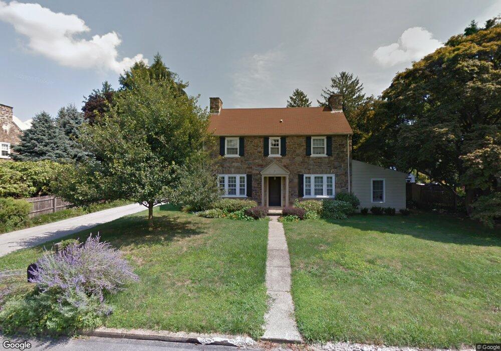
34 Elmwood Dr Kennett Square, PA 19348
Estimated Value: $559,085 - $761,000
4
Beds
2
Baths
2,036
Sq Ft
$311/Sq Ft
Est. Value
About This Home
This home is located at 34 Elmwood Dr, Kennett Square, PA 19348 and is currently estimated at $634,021, approximately $311 per square foot. 34 Elmwood Dr is a home located in Chester County with nearby schools including Kennett Middle School, Kennett High School, and St. Patrick School.
Ownership History
Date
Name
Owned For
Owner Type
Purchase Details
Closed on
Jan 3, 2020
Sold by
Stewart Carol S
Bought by
Dupont Priscilla Altmaier
Current Estimated Value
Purchase Details
Closed on
Nov 21, 1996
Sold by
Poston David S and Poston Susan W
Bought by
Kleinhans Teresa and Scott John R
Home Financials for this Owner
Home Financials are based on the most recent Mortgage that was taken out on this home.
Original Mortgage
$180,500
Interest Rate
7.82%
Create a Home Valuation Report for This Property
The Home Valuation Report is an in-depth analysis detailing your home's value as well as a comparison with similar homes in the area
Home Values in the Area
Average Home Value in this Area
Purchase History
| Date | Buyer | Sale Price | Title Company |
|---|---|---|---|
| Dupont Priscilla Altmaier | $421,500 | None Available | |
| Kleinhans Teresa | $190,000 | -- |
Source: Public Records
Mortgage History
| Date | Status | Borrower | Loan Amount |
|---|---|---|---|
| Previous Owner | Kleinhans Teresa | $180,500 |
Source: Public Records
Tax History Compared to Growth
Tax History
| Year | Tax Paid | Tax Assessment Tax Assessment Total Assessment is a certain percentage of the fair market value that is determined by local assessors to be the total taxable value of land and additions on the property. | Land | Improvement |
|---|---|---|---|---|
| 2025 | $7,340 | $179,990 | $51,620 | $128,370 |
| 2024 | $7,340 | $179,990 | $51,620 | $128,370 |
| 2023 | $7,197 | $179,990 | $51,620 | $128,370 |
| 2022 | $7,006 | $179,990 | $51,620 | $128,370 |
| 2021 | $6,900 | $179,990 | $51,620 | $128,370 |
| 2020 | $6,771 | $179,990 | $51,620 | $128,370 |
| 2019 | $6,681 | $179,990 | $51,620 | $128,370 |
| 2018 | $6,542 | $179,990 | $51,620 | $128,370 |
| 2017 | $6,085 | $179,990 | $51,620 | $128,370 |
| 2016 | $714 | $179,990 | $51,620 | $128,370 |
| 2015 | $714 | $179,990 | $51,620 | $128,370 |
| 2014 | $714 | $179,990 | $51,620 | $128,370 |
Source: Public Records
Map
Nearby Homes
- 962 E Baltimore Pike
- 501 Orchard Ln
- 407 Anvil Dr
- 993 Baneswood Dr
- 39 E Jonathan Ct
- 24 W Jonathan Ct
- 989 Sills Mill Rd Unit MARSHALLTON
- 989 Sills Mill Rd Unit LAFAYETTE
- 989 Sills Mill Rd Unit THORNBURY
- 993 Sills Mill Rd
- 997 Sills Mill Rd
- 1936 Lenape Rd
- 123 Federal Walk
- 7 Evergreen Ct
- 1392 Hickory Hill Rd
- 1702 W Street Rd
- 327 E Street Rd
- 470 E Hillendale Rd
- 821 Burrows Run Rd
- 323 E Street Rd