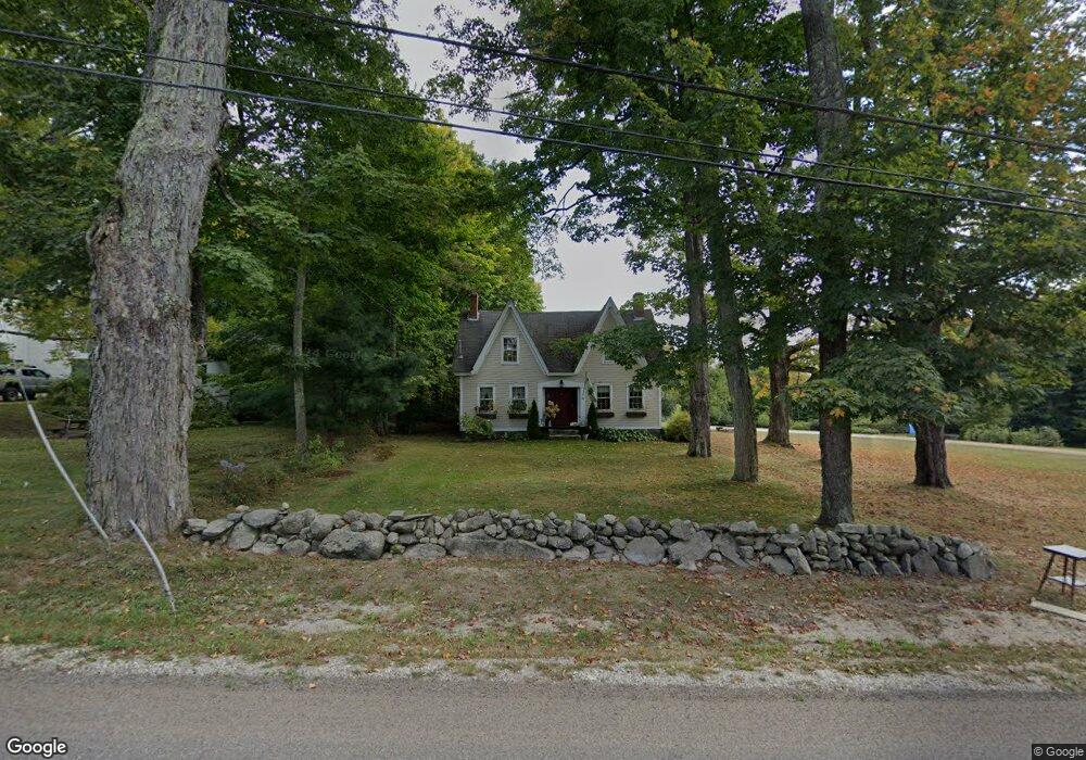
34 Gloucester Hill Rd New Gloucester, ME 04260
Estimated Value: $465,000 - $552,000
4
Beds
2
Baths
2,278
Sq Ft
$222/Sq Ft
Est. Value
About This Home
This home is located at 34 Gloucester Hill Rd, New Gloucester, ME 04260 and is currently estimated at $505,944, approximately $222 per square foot. 34 Gloucester Hill Rd is a home located in Cumberland County with nearby schools including Gray-New Gloucester High School.
Ownership History
Date
Name
Owned For
Owner Type
Purchase Details
Closed on
May 22, 2009
Sold by
Lancaster Frederick
Bought by
Moran David A and Moran Elizabeth
Current Estimated Value
Home Financials for this Owner
Home Financials are based on the most recent Mortgage that was taken out on this home.
Original Mortgage
$245,000
Outstanding Balance
$154,127
Interest Rate
4.93%
Mortgage Type
Unknown
Estimated Equity
$351,817
Purchase Details
Closed on
Nov 10, 2008
Sold by
Fiorentino Jacqueline S
Bought by
Lancaster Frederick
Create a Home Valuation Report for This Property
The Home Valuation Report is an in-depth analysis detailing your home's value as well as a comparison with similar homes in the area
Home Values in the Area
Average Home Value in this Area
Purchase History
| Date | Buyer | Sale Price | Title Company |
|---|---|---|---|
| Moran David A | -- | -- | |
| Lancaster Frederick | -- | -- |
Source: Public Records
Mortgage History
| Date | Status | Borrower | Loan Amount |
|---|---|---|---|
| Open | Lancaster Frederick | $245,000 |
Source: Public Records
Tax History Compared to Growth
Tax History
| Year | Tax Paid | Tax Assessment Tax Assessment Total Assessment is a certain percentage of the fair market value that is determined by local assessors to be the total taxable value of land and additions on the property. | Land | Improvement |
|---|---|---|---|---|
| 2025 | $4,784 | $309,271 | $99,240 | $210,031 |
| 2024 | $4,605 | $309,271 | $99,240 | $210,031 |
| 2023 | $4,419 | $309,271 | $99,240 | $210,031 |
| 2022 | $4,268 | $309,271 | $99,240 | $210,031 |
| 2021 | $4,268 | $309,271 | $99,240 | $210,031 |
| 2020 | $4,222 | $309,271 | $99,240 | $210,031 |
| 2019 | $4,653 | $275,300 | $62,800 | $212,500 |
| 2018 | $4,350 | $275,300 | $62,800 | $212,500 |
| 2017 | $4,295 | $275,300 | $62,800 | $212,500 |
| 2016 | $4,047 | $275,300 | $62,800 | $212,500 |
| 2015 | $4,033 | $275,300 | $62,800 | $212,500 |
| 2014 | $3,992 | $275,300 | $62,800 | $212,500 |
| 2013 | $3,703 | $275,300 | $62,800 | $212,500 |
Source: Public Records
Map
Nearby Homes
- 10 Cobbs Bridge Rd
- 160 Gloucester Hill Rd
- 155 & 151 Gloucester Hill Rd
- 0018-C Gloucester Hill Rd
- 164 Intervale Rd
- 22 Shaw Rd
- 200 Woodman Rd
- 271 Bennett Rd
- 29 Rockwood Dr
- TBD Targett Rd
- 12 Country Charm Ln
- 24 Swamp Rd
- 10-56 C&E Bowdoin Way
- 65 Blueberry Ln
- 14 Golden Way
- 0 Mayall
- 423 Sabbathday Rd
- 343 Shaker Rd
- 161 Beaver Dam Dr
- 284 Allen Rd
- 30 Gloucester Hill Rd
- 29 Gloucester Hill Rd
- 50 Gloucester Hill Rd
- 20 Gloucester Hill Rd
- 47 Gloucester Hill Rd
- 12 Gloucester Hill Rd
- 8 Gloucester Hill Rd
- 5 Gloucester Hill Rd
- 0 Taylors Trail Unit 1568467
- 0 Taylors Trail Unit 1326647
- 4 Gloucester Hill Rd
- 417 Intervale Rd
- 405 Intervale Rd
- 425 Intervale Rd
- 0 Gloucester Hill
- 61 Gloucester Hill Rd
- 182 Church Rd
- 185 Church Rd
- 400 Intervale Rd
- 0 Cobb's Bridge