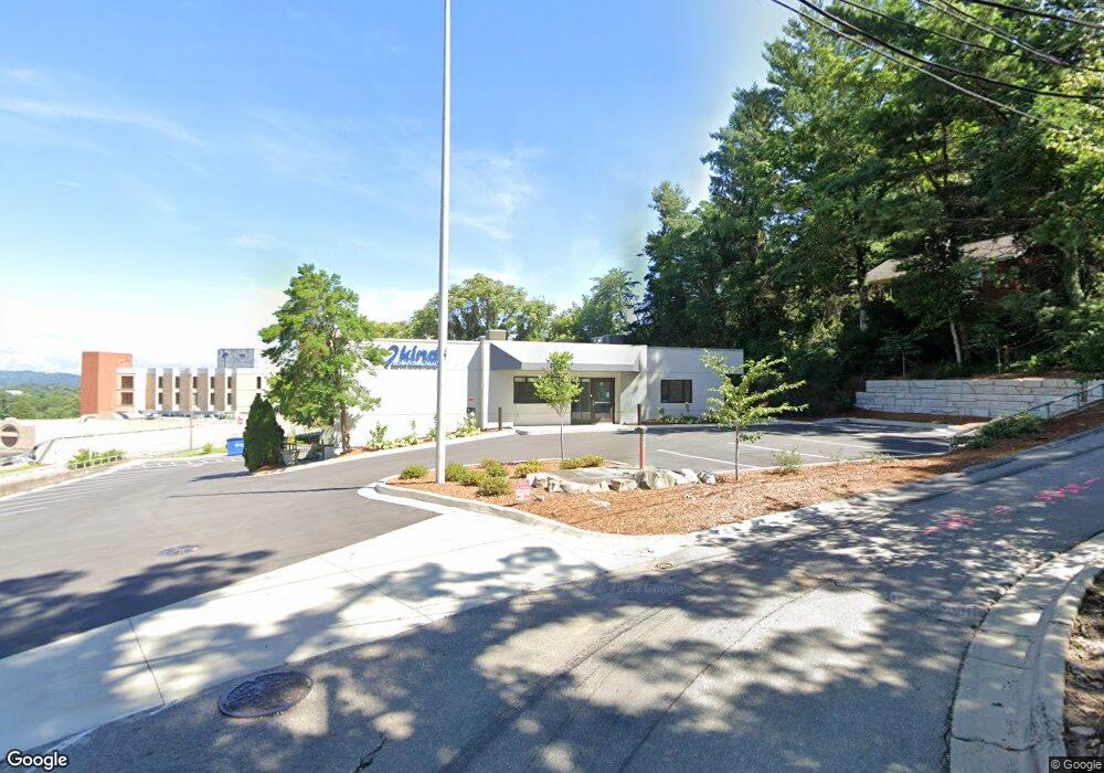
34 Granby St Asheville, NC 28801
East End Neighborhood
--
Bed
--
Bath
4,588
Sq Ft
0.52
Acres
About This Home
This home is located at 34 Granby St, Asheville, NC 28801. 34 Granby St is a home located in Buncombe County with nearby schools including Isaac Dickson Elementary, Hall Fletcher Elementary, and Ira B Jones Elementary.
Ownership History
Date
Name
Owned For
Owner Type
Purchase Details
Closed on
Sep 11, 2014
Sold by
Hha Asheville Llc
Bought by
Gmr Ashville Llc
Purchase Details
Closed on
Mar 5, 2002
Sold by
Sre/Asheville Land Company Llc
Bought by
Hha Asheville Llc
Home Financials for this Owner
Home Financials are based on the most recent Mortgage that was taken out on this home.
Original Mortgage
$1,350,000
Interest Rate
6.95%
Mortgage Type
Commercial
Purchase Details
Closed on
Mar 30, 2001
Sold by
Crosby E Brown
Bought by
Sre Asheville Land Company Llc
Create a Home Valuation Report for This Property
The Home Valuation Report is an in-depth analysis detailing your home's value as well as a comparison with similar homes in the area
Home Values in the Area
Average Home Value in this Area
Purchase History
| Date | Buyer | Sale Price | Title Company |
|---|---|---|---|
| Gmr Ashville Llc | $2,420,000 | None Available | |
| Hha Asheville Llc | $1,400,000 | -- | |
| Sre Asheville Land Company Llc | -- | -- | |
| Sre Asheville Land Company Llc | $1,375,000 | -- |
Source: Public Records
Mortgage History
| Date | Status | Borrower | Loan Amount |
|---|---|---|---|
| Previous Owner | Hha Asheville Llc | $1,350,000 |
Source: Public Records
Tax History Compared to Growth
Tax History
| Year | Tax Paid | Tax Assessment Tax Assessment Total Assessment is a certain percentage of the fair market value that is determined by local assessors to be the total taxable value of land and additions on the property. | Land | Improvement |
|---|---|---|---|---|
| 2025 | $26,852 | $2,599,200 | $475,700 | $2,123,500 |
| 2024 | $26,852 | $2,599,200 | $475,700 | $2,123,500 |
| 2023 | $26,852 | $2,599,200 | $475,700 | $2,123,500 |
| 2022 | $25,919 | $2,599,200 | $0 | $0 |
| 2021 | $25,919 | $2,599,200 | $0 | $0 |
| 2020 | $24,542 | $2,276,800 | $0 | $0 |
| 2019 | $24,542 | $2,276,800 | $0 | $0 |
| 2018 | $24,542 | $2,276,800 | $0 | $0 |
| 2017 | $24,769 | $1,369,400 | $0 | $0 |
| 2016 | $16,830 | $1,369,400 | $0 | $0 |
| 2015 | $16,830 | $1,369,400 | $0 | $0 |
| 2014 | $16,625 | $1,369,400 | $0 | $0 |
Source: Public Records
Map
Nearby Homes
- 56 Sherwood Rd
- 64 Wyoming Rd
- 109 Thurland Ave
- 22 Pine Grove Ave
- 3 Lee Garden Ln Unit 103
- 3 Lee Garden Ln Unit 204
- 3 Lee Garden Ln Unit 105
- 44 Samuel Ashe Dr Unit 55
- 44 Samuel Ashe Dr
- 20 & 28 Toby Dr
- 272 Biltmore Ave
- 615 Biltmore Ave Unit M3
- 615 Biltmore Ave Unit K2
- 71 Buchanan Ave
- 22 Samuel Ashe Dr Unit 45
- 53 Buchanan Place
- 38 Unadilla Alley
- 13 Castle St Unit A and B
- 110 Unadilla Ave
- 19 Castle St