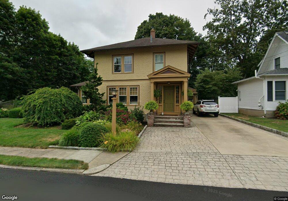
34 Hixon Ct North Attleboro, MA 02760
North Attleboro NeighborhoodEstimated Value: $520,000 - $642,000
3
Beds
2
Baths
1,836
Sq Ft
$309/Sq Ft
Est. Value
About This Home
This home is located at 34 Hixon Ct, North Attleboro, MA 02760 and is currently estimated at $567,000, approximately $308 per square foot. 34 Hixon Ct is a home located in Bristol County with nearby schools including North Attleboro High School, Cadence Academy Preschool - North Attleborough, and Bishop Feehan High School.
Ownership History
Date
Name
Owned For
Owner Type
Purchase Details
Closed on
Dec 28, 1999
Sold by
Hasson Robert G and Hasson Susan L
Bought by
Butt Randy A and Butt Amy
Current Estimated Value
Create a Home Valuation Report for This Property
The Home Valuation Report is an in-depth analysis detailing your home's value as well as a comparison with similar homes in the area
Home Values in the Area
Average Home Value in this Area
Purchase History
| Date | Buyer | Sale Price | Title Company |
|---|---|---|---|
| Butt Randy A | $166,000 | -- |
Source: Public Records
Mortgage History
| Date | Status | Borrower | Loan Amount |
|---|---|---|---|
| Open | Butt Randy A | $200,000 | |
| Closed | Butt Randy A | $198,000 | |
| Closed | Butt Randy A | $141,000 |
Source: Public Records
Tax History Compared to Growth
Tax History
| Year | Tax Paid | Tax Assessment Tax Assessment Total Assessment is a certain percentage of the fair market value that is determined by local assessors to be the total taxable value of land and additions on the property. | Land | Improvement |
|---|---|---|---|---|
| 2025 | $6,084 | $516,000 | $130,600 | $385,400 |
| 2024 | $5,797 | $502,300 | $130,600 | $371,700 |
| 2023 | $5,614 | $438,900 | $136,300 | $302,600 |
| 2022 | $5,481 | $393,500 | $130,600 | $262,900 |
| 2021 | $5,273 | $369,500 | $130,600 | $238,900 |
| 2020 | $5,221 | $363,800 | $130,600 | $233,200 |
| 2019 | $4,876 | $342,400 | $118,700 | $223,700 |
| 2018 | $4,313 | $323,300 | $118,700 | $204,600 |
| 2017 | $4,023 | $304,300 | $118,700 | $185,600 |
| 2016 | $3,846 | $290,900 | $137,700 | $153,200 |
| 2015 | $3,648 | $277,600 | $143,400 | $134,200 |
| 2014 | $3,620 | $273,400 | $125,900 | $147,500 |
Source: Public Records
Map
Nearby Homes
- 80 Broadway Unit 9
- 137 Sumner St
- 93 Bank St
- 50 Metcalf Rd
- 16 Richards Ave Unit 106
- 300 E Washington St Unit 54R
- 40 Roosevelt Ave
- 160 Crescent Ave
- 130 E Washington St Unit 57
- 130 E Washington St Unit 71
- 130 E Washington St Unit 36
- 19 Church St Unit C9
- 12 Roosevelt Ave
- 16 Johnson St
- 27 Taylor St
- 46 Westside Ave
- 30 Sperry Ln Unit Lot 15
- 0 Anawan Rd
- 880 Landry Ave Unit 2
- 42 2nd Ave Unit 24