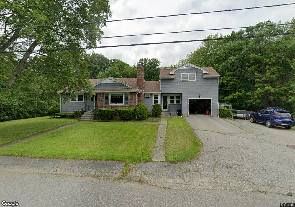
34 Middleton St Millbury, MA 01527
Estimated Value: $542,000 - $602,476
3
Beds
3
Baths
2,163
Sq Ft
$265/Sq Ft
Est. Value
About This Home
This home is located at 34 Middleton St, Millbury, MA 01527 and is currently estimated at $573,119, approximately $264 per square foot. 34 Middleton St is a home located in Worcester County with nearby schools including Elmwood Street Elementary School, Raymond E. Shaw Elementary School, and Millbury Junior/Senior High School.
Ownership History
Date
Name
Owned For
Owner Type
Purchase Details
Closed on
Apr 21, 1989
Sold by
Bien Dorothea
Bought by
Charette David R
Current Estimated Value
Home Financials for this Owner
Home Financials are based on the most recent Mortgage that was taken out on this home.
Original Mortgage
$95,000
Interest Rate
10.79%
Mortgage Type
Purchase Money Mortgage
Create a Home Valuation Report for This Property
The Home Valuation Report is an in-depth analysis detailing your home's value as well as a comparison with similar homes in the area
Home Values in the Area
Average Home Value in this Area
Purchase History
| Date | Buyer | Sale Price | Title Company |
|---|---|---|---|
| Charette David R | $125,000 | -- |
Source: Public Records
Mortgage History
| Date | Status | Borrower | Loan Amount |
|---|---|---|---|
| Closed | Charette David R | $95,000 | |
| Closed | Charette David R | $95,000 |
Source: Public Records
Tax History Compared to Growth
Tax History
| Year | Tax Paid | Tax Assessment Tax Assessment Total Assessment is a certain percentage of the fair market value that is determined by local assessors to be the total taxable value of land and additions on the property. | Land | Improvement |
|---|---|---|---|---|
| 2025 | $6,635 | $495,500 | $114,500 | $381,000 |
| 2024 | $6,090 | $460,300 | $106,000 | $354,300 |
| 2023 | $5,452 | $377,300 | $74,400 | $302,900 |
| 2022 | $5,256 | $350,400 | $74,400 | $276,000 |
| 2021 | $3,149 | $332,500 | $74,400 | $258,100 |
| 2020 | $4,995 | $325,800 | $74,400 | $251,400 |
| 2019 | $4,381 | $276,400 | $67,600 | $208,800 |
| 2018 | $4,095 | $250,600 | $67,600 | $183,000 |
| 2017 | $3,887 | $236,600 | $67,600 | $169,000 |
| 2016 | $3,593 | $218,300 | $67,600 | $150,700 |
| 2015 | $3,601 | $218,800 | $71,800 | $147,000 |
| 2014 | $3,394 | $198,500 | $71,800 | $126,700 |
Source: Public Records
Map
Nearby Homes
- 11 Maplewood Rd
- 27 A-B Grafton St
- 12 Irene Ct
- 1 Hastings Ave
- 2 Diane St
- 76 Weatherstone Dr
- 39 Pointe Rok Dr Unit 39
- 31 Pointe Rok Dr Unit 31
- 255 Riverlin St
- 1218 Grafton St
- 95 Pineland Ave
- 1203 Grafton St Unit 38
- 31 Crane St
- 1195 Grafton St Unit 4
- 1195 Grafton St Unit 3
- 1 Broadmeadow Ave
- 20 Duluth St
- 11 Margin St
- 21 Lordvale Blvd Unit 406
- 330 Millbury Ave
- 36 Middleton St
- 27 B Middleton St Unit B
- 27 Middleton St
- 27 Middleton St Unit B
- 27 Marion Ave
- 33 Middleton St
- 29 Marion Ave
- 25 Marion Ave
- 23 Marion Ave
- 24 Middleton St
- 31 Marion Ave
- 21 Marion Ave
- 19 Marion Ave
- 26 Marion Ave
- 184 Wheelock Ave
- 1 Henry St
- 184A Wheelock Ave
- 18 Middleton St
- 17A Middleton St Unit C
- 22 Marion Ave