
Seller's Agent in 2025
Michelle Pais
Signature Realty NJ LLC - Westfield
(908) 868-6581
8 in this area
134 Total Sales
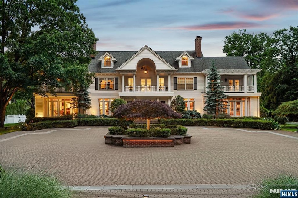
Tucked behind the gates of prestigious Llewellyn Park, this distinguished estate blends timeless elegance with modern luxury on nearly 2 acres. Rebuilt from the foundation in the 1990s and beautifully renovated in 2022, the 6-bedroom, 8.3-bath residence spans five levels with elevator access. A grand staircase and soaring ceilings lead to herringbone wood floors, arched doorways, and sun-drenched living spaces. The formal living room with a marble fireplace opens to a sun-drenched sitting room, while a character-rich office with a spiral staircase offers direct access to the primary suite above. The banquet-sized dining room, adorned with a Carrara marble fireplace and Murano-style chandelier, flows into the chef's kitchen featuring radiant heated floors, top-tier appliances, and a bright breakfast area. Upstairs, the expansive primary suite is a private haven with dual spa baths, two walk-in closets, a dressing room, gym, coffee bar, and a serene balcony. A separate level holds a recreation room with en-suite bath, sitting area, and storage. The finished basement includes a custom, soundproofed recording studio ideal for music, podcasting, or content creation. Outside, enjoy a heated infinity pool, spa, pergola with retractable awning and fireplace, sport court, and a separate 1-bed/1-bath Carriage House perfect for guests. Sq footage is apppx *
Last Agent to Sell the Property
Signature Realty NJ LLC - Westfield Listed on: 06/11/2025
| Date | Type | Sale Price | Title Company |
|---|---|---|---|
| Deed | $3,200,000 | Old Republic National Title | |
| Deed | $2,399,000 | First American Title | |
| Deed | $2,200,000 | -- | |
| Deed | $935,000 | -- |
| Date | Status | Loan Amount | Loan Type |
|---|---|---|---|
| Open | $2,560,000 | New Conventional | |
| Previous Owner | $1,919,200 | New Conventional | |
| Previous Owner | $1,600,000 | No Value Available |
| Date | Event | Price | List to Sale | Price per Sq Ft |
|---|---|---|---|---|
| 09/10/2025 09/10/25 | Sold | $3,200,000 | +6.7% | -- |
| 07/22/2025 07/22/25 | Pending | -- | -- | -- |
| 06/11/2025 06/11/25 | For Sale | $2,999,999 | -- | -- |
| Year | Tax Paid | Tax Assessment Tax Assessment Total Assessment is a certain percentage of the fair market value that is determined by local assessors to be the total taxable value of land and additions on the property. | Land | Improvement |
|---|---|---|---|---|
| 2025 | $59,774 | $2,625,500 | $577,300 | $2,048,200 |
| 2024 | $59,774 | $1,300,000 | $364,500 | $935,500 |
| 2022 | $62,118 | $1,400,000 | $364,500 | $1,035,500 |
| 2021 | $68,693 | $1,577,700 | $364,500 | $1,213,200 |
| 2020 | $67,589 | $1,577,700 | $364,500 | $1,213,200 |
| 2019 | $65,648 | $1,577,700 | $364,500 | $1,213,200 |
| 2018 | $63,708 | $1,577,700 | $364,500 | $1,213,200 |
| 2017 | $62,887 | $1,577,700 | $364,500 | $1,213,200 |
| 2016 | $66,433 | $1,707,800 | $364,500 | $1,343,300 |
| 2015 | $60,221 | $1,519,900 | $364,500 | $1,155,400 |
| 2014 | $56,875 | $1,519,900 | $364,500 | $1,155,400 |
Seller's Agent in 2025
Michelle Pais
Signature Realty NJ LLC - Westfield
(908) 868-6581
8 in this area
134 Total Sales
Buyer's Agent in 2025
Andrew Chung
Group Twenty Six, LLC
(917) 548-4255
1 in this area
15 Total Sales
Source: New Jersey MLS
MLS Number: 25020263
APN: 22-00096-0000-00003
Disclaimer: Certain information contained herein is derived from information provided by parties other than Homes.com. All information provided is deemed reliable, but is not guaranteed to be accurate and should be independently verified.
![]() The data relating to the real estate for sale on this web site comes in part from the Internet Data Exchange Program of the NJMLS. Real estate listings held by brokerage firms other than Ten-X are marked with the Internet Data Exchange logo and information about them includes the name of the listing brokers. Some properties listed with the participating brokers do not appear on this website at the request of the seller. Listings of brokers that do not participate in Internet Data Exchange do not appear on this website.
The data relating to the real estate for sale on this web site comes in part from the Internet Data Exchange Program of the NJMLS. Real estate listings held by brokerage firms other than Ten-X are marked with the Internet Data Exchange logo and information about them includes the name of the listing brokers. Some properties listed with the participating brokers do not appear on this website at the request of the seller. Listings of brokers that do not participate in Internet Data Exchange do not appear on this website.
All information deemed reliable but not guaranteed. Source: New Jersey Multiple Listing, Inc.
© 2025 New Jersey Multiple Listing Service Inc. All rights reserved.