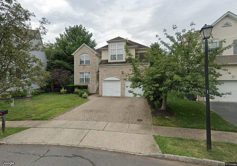
34 Prall Rd Hillsborough, NJ 08844
Estimated Value: $793,293 - $915,000
--
Bed
--
Bath
2,638
Sq Ft
$324/Sq Ft
Est. Value
About This Home
This home is located at 34 Prall Rd, Hillsborough, NJ 08844 and is currently estimated at $854,823, approximately $324 per square foot. 34 Prall Rd is a home located in Somerset County with nearby schools including Hillsborough High School, Brighthorizons at Hillsborough, and Cherry Blossom Montessori School.
Ownership History
Date
Name
Owned For
Owner Type
Purchase Details
Closed on
Jun 21, 2001
Sold by
Amoruso Raymond
Bought by
Mcmahon Robert and Mcmahon Elaine
Current Estimated Value
Home Financials for this Owner
Home Financials are based on the most recent Mortgage that was taken out on this home.
Original Mortgage
$275,000
Outstanding Balance
$104,753
Interest Rate
7.14%
Estimated Equity
$750,070
Purchase Details
Closed on
Apr 15, 1998
Sold by
Vizco I Llc
Bought by
Amoruso Raymond and Amoruso Theresa M
Home Financials for this Owner
Home Financials are based on the most recent Mortgage that was taken out on this home.
Original Mortgage
$215,000
Interest Rate
7.11%
Create a Home Valuation Report for This Property
The Home Valuation Report is an in-depth analysis detailing your home's value as well as a comparison with similar homes in the area
Home Values in the Area
Average Home Value in this Area
Purchase History
| Date | Buyer | Sale Price | Title Company |
|---|---|---|---|
| Mcmahon Robert | $376,000 | -- | |
| Amoruso Raymond | $268,500 | -- |
Source: Public Records
Mortgage History
| Date | Status | Borrower | Loan Amount |
|---|---|---|---|
| Open | Mcmahon Robert | $275,000 | |
| Previous Owner | Amoruso Raymond | $215,000 |
Source: Public Records
Tax History Compared to Growth
Tax History
| Year | Tax Paid | Tax Assessment Tax Assessment Total Assessment is a certain percentage of the fair market value that is determined by local assessors to be the total taxable value of land and additions on the property. | Land | Improvement |
|---|---|---|---|---|
| 2025 | $13,229 | $694,700 | $320,300 | $374,400 |
| 2024 | $13,229 | $617,300 | $325,300 | $292,000 |
| 2023 | $12,251 | $569,000 | $275,300 | $293,700 |
| 2022 | $12,143 | $543,800 | $275,300 | $268,500 |
| 2021 | $11,984 | $510,400 | $240,300 | $270,100 |
| 2020 | $12,533 | $525,700 | $230,300 | $295,400 |
| 2019 | $12,436 | $517,300 | $220,300 | $297,000 |
| 2018 | $12,148 | $502,200 | $200,300 | $301,900 |
| 2017 | $11,937 | $494,300 | $190,300 | $304,000 |
| 2016 | $11,971 | $495,900 | $190,300 | $305,600 |
| 2015 | $11,198 | $469,700 | $190,300 | $279,400 |
| 2014 | $10,414 | $446,200 | $165,300 | $280,900 |
Source: Public Records
Map
Nearby Homes
- 912 Merritt Dr Unit D
- 104 Devonshire Ct
- 902 Merritt Dr Unit E
- 911 Merritt Dr Unit B2
- 303 Gemini Dr Unit 2B
- 710 Whitenack Ct
- 7 Monfort Dr
- 118 Bluebird Dr Unit 3
- 195 Beekman Ln
- 911 Renate Dr Unit 1
- 3120 Revere Ct
- 107 Bluebird Dr Unit 1D
- 3204 Revere Ct
- 807 Eves Dr Unit 1B
- 3014 Revere Ct
- 3011 Revere Ct
- 3007 Revere Ct
- 68 Dunedain St
- 790 Eves Dr
- 806 Eves Dr Unit 1B