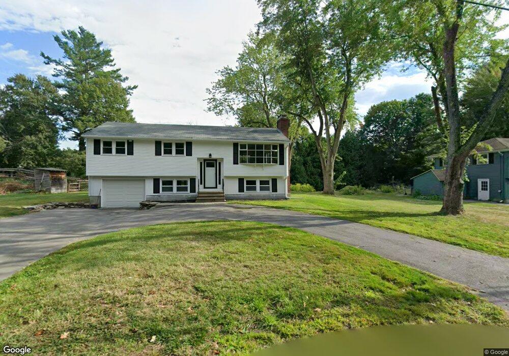
34 Rangely Rd Lunenburg, MA 01462
Estimated Value: $504,000 - $580,000
3
Beds
2
Baths
1,401
Sq Ft
$386/Sq Ft
Est. Value
About This Home
This home is located at 34 Rangely Rd, Lunenburg, MA 01462 and is currently estimated at $541,483, approximately $386 per square foot. 34 Rangely Rd is a home located in Worcester County with nearby schools including Lunenburg Primary School, Lunenburg High School, and St Bernards Elementary School.
Ownership History
Date
Name
Owned For
Owner Type
Purchase Details
Closed on
May 28, 2019
Sold by
Howley Michael P and Howley Virgen
Bought by
Preeper Nichole M
Current Estimated Value
Home Financials for this Owner
Home Financials are based on the most recent Mortgage that was taken out on this home.
Original Mortgage
$265,000
Outstanding Balance
$233,000
Interest Rate
4.1%
Mortgage Type
New Conventional
Estimated Equity
$308,483
Purchase Details
Closed on
Oct 12, 2000
Sold by
Byrne Frank J and Byrne Julie A
Bought by
Howley Michael P
Home Financials for this Owner
Home Financials are based on the most recent Mortgage that was taken out on this home.
Original Mortgage
$181,600
Interest Rate
7.89%
Mortgage Type
Purchase Money Mortgage
Purchase Details
Closed on
Oct 1, 1990
Sold by
Betmilsen #4 Inc
Bought by
Byrne Frank J
Create a Home Valuation Report for This Property
The Home Valuation Report is an in-depth analysis detailing your home's value as well as a comparison with similar homes in the area
Home Values in the Area
Average Home Value in this Area
Purchase History
| Date | Buyer | Sale Price | Title Company |
|---|---|---|---|
| Preeper Nichole M | $280,000 | -- | |
| Howley Michael P | $227,000 | -- | |
| Byrne Frank J | $134,500 | -- |
Source: Public Records
Mortgage History
| Date | Status | Borrower | Loan Amount |
|---|---|---|---|
| Open | Preeper Nichole M | $265,000 | |
| Previous Owner | Byrne Frank J | $181,600 | |
| Previous Owner | Byrne Frank J | $19,000 | |
| Previous Owner | Byrne Frank J | $65,000 |
Source: Public Records
Tax History
| Year | Tax Paid | Tax Assessment Tax Assessment Total Assessment is a certain percentage of the fair market value that is determined by local assessors to be the total taxable value of land and additions on the property. | Land | Improvement |
|---|---|---|---|---|
| 2025 | $6,377 | $444,100 | $122,000 | $322,100 |
| 2024 | $5,976 | $423,800 | $115,000 | $308,800 |
| 2023 | $5,494 | $375,800 | $104,600 | $271,200 |
| 2022 | $5,224 | $303,900 | $87,200 | $216,700 |
| 2020 | $5,117 | $282,400 | $87,200 | $195,200 |
| 2019 | $5,027 | $269,100 | $82,100 | $187,000 |
| 2018 | $4,746 | $240,900 | $82,100 | $158,800 |
| 2017 | $4,569 | $228,700 | $74,800 | $153,900 |
| 2016 | $4,222 | $215,300 | $71,100 | $144,200 |
| 2015 | $3,822 | $208,600 | $67,500 | $141,100 |
Source: Public Records
Map
Nearby Homes
- 365 Hollis Rd
- 77 Electric Ave
- 558 Massachusetts Ave
- 2 Riley Rd Unit B
- 37 Wallis Park
- 830 Massachusetts Ave
- 711 Massachusetts Ave Unit 2
- 711 Massachusetts Ave Unit 4
- 35 Leominster Rd
- 87 Norwood Ave
- 3 Rennie St
- 319 Highland St
- 63 Holman St
- 5 Ramgren Rd
- 49 Pleasant St
- 9 Pleasant St
- 24 North St
- 87 Dartmouth St
- 50 Old Farm Rd
- 363 Lunenburg St