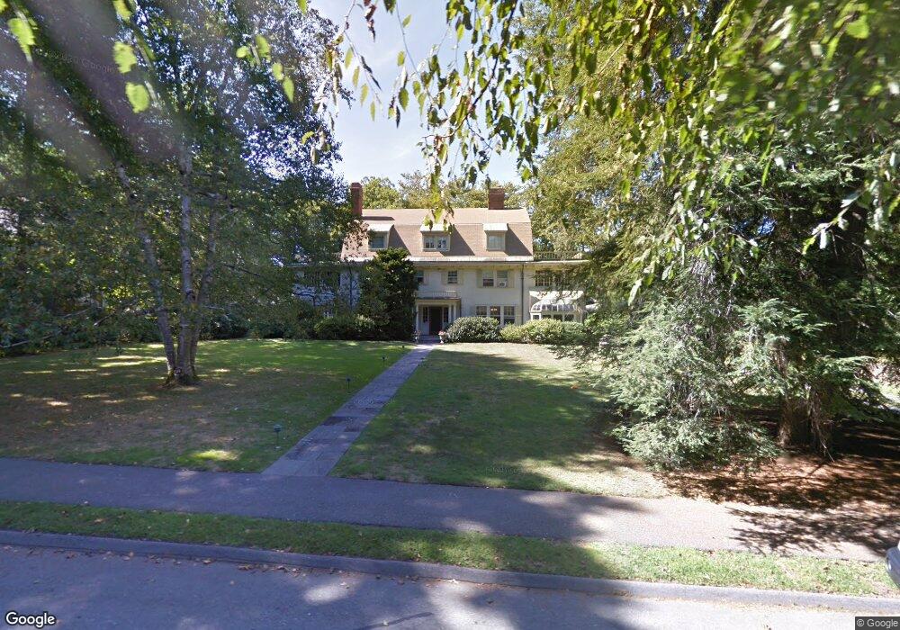
34 Spooner Rd Chestnut Hill, MA 02467
Chestnut Hill NeighborhoodEstimated Value: $4,350,094 - $6,358,000
8
Beds
6
Baths
5,800
Sq Ft
$929/Sq Ft
Est. Value
About This Home
This home is located at 34 Spooner Rd, Chestnut Hill, MA 02467 and is currently estimated at $5,387,024, approximately $928 per square foot. 34 Spooner Rd is a home located in Norfolk County with nearby schools including Heath Elementary School, Brimmer & May School, and The Chestnut Hill School.
Ownership History
Date
Name
Owned For
Owner Type
Purchase Details
Closed on
Nov 7, 2008
Sold by
Shepard Klaudia S
Bought by
Wood Elizabeth M and Wood Robert Y
Current Estimated Value
Home Financials for this Owner
Home Financials are based on the most recent Mortgage that was taken out on this home.
Original Mortgage
$800,000
Outstanding Balance
$525,139
Interest Rate
6.08%
Mortgage Type
Purchase Money Mortgage
Estimated Equity
$4,861,885
Create a Home Valuation Report for This Property
The Home Valuation Report is an in-depth analysis detailing your home's value as well as a comparison with similar homes in the area
Home Values in the Area
Average Home Value in this Area
Purchase History
| Date | Buyer | Sale Price | Title Company |
|---|---|---|---|
| Wood Elizabeth M | $2,408,026 | -- | |
| Wood Elizabeth M | $2,408,026 | -- |
Source: Public Records
Mortgage History
| Date | Status | Borrower | Loan Amount |
|---|---|---|---|
| Open | Wood Elizabeth M | $800,000 | |
| Closed | Wood Elizabeth M | $800,000 |
Source: Public Records
Tax History Compared to Growth
Tax History
| Year | Tax Paid | Tax Assessment Tax Assessment Total Assessment is a certain percentage of the fair market value that is determined by local assessors to be the total taxable value of land and additions on the property. | Land | Improvement |
|---|---|---|---|---|
| 2025 | $52,209 | $5,289,700 | $2,595,600 | $2,694,100 |
| 2024 | $49,745 | $5,091,600 | $2,495,700 | $2,595,900 |
| 2023 | $42,620 | $4,274,800 | $1,783,100 | $2,491,700 |
| 2022 | $41,485 | $4,071,100 | $1,698,100 | $2,373,000 |
| 2021 | $38,363 | $3,914,600 | $1,632,800 | $2,281,800 |
| 2020 | $35,298 | $3,735,200 | $1,484,400 | $2,250,800 |
| 2019 | $33,332 | $3,557,300 | $1,413,700 | $2,143,600 |
| 2018 | $33,427 | $3,533,500 | $1,457,200 | $2,076,300 |
| 2017 | $25,774 | $2,608,700 | $1,374,700 | $1,234,000 |
| 2016 | $25,404 | $2,438,000 | $1,284,700 | $1,153,300 |
| 2015 | $24,334 | $2,278,500 | $1,200,700 | $1,077,800 |
| 2014 | $24,022 | $2,109,000 | $1,091,600 | $1,017,400 |
Source: Public Records
Map
Nearby Homes
- 174 Middlesex Rd
- 142 Crafts Rd
- 76 Norfolk Rd
- 1014 Boylston St
- 335 Heath St
- 85 Gate House Rd
- 130 Cabot St
- 59 Ackers Ave Unit 1
- 88 Cutler Ln
- 2400 Beacon St Unit 112
- 30 Ackers Ave
- 55 Reservoir Rd Unit 2
- 0 Glenoe Rd
- 540 Chestnut Hill Ave
- 3 Glenoe Rd
- 9 Willard Rd
- 675 Chestnut Hill Ave
- 6 Sutherland Rd Unit 41
- 44 Orkney Rd Unit 3
- 41 Orkney Rd
- 24 Spooner Rd
- 175 Middlesex Rd
- 50 Spooner Rd
- 18 Spooner Rd
- 163 Middlesex Rd
- 35 Spooner Rd
- 41 Spooner Rd
- 157 Middlesex Rd
- 56 Spooner Rd
- 51 Spooner Rd
- 183 Middlesex Rd
- 151 Middlesex Rd
- 170 Middlesex Rd
- 170 Middlesex Rd
- 195 Middlesex Rd
- 142 Middlesex Rd Unit 144
- 142 Middlesex Rd Unit 144
- 142 Middlesex Rd Unit 144
- 142 Middlesex Rd Unit 144
- 142 Middlesex Rd Unit 144