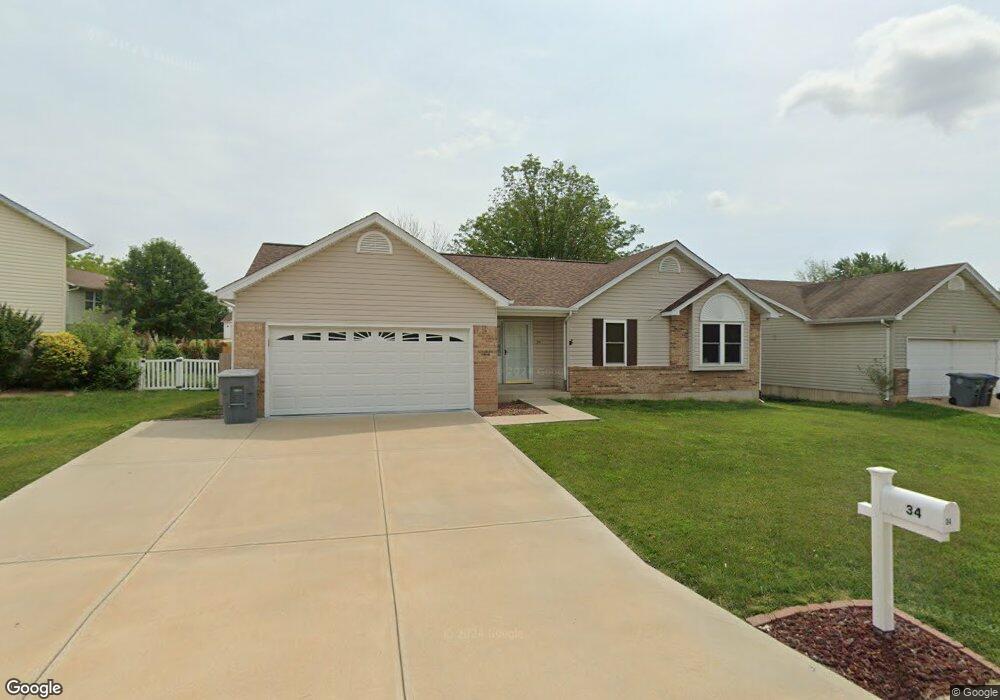
34 Tailor Ct O Fallon, MO 63368
Estimated Value: $288,000 - $337,000
3
Beds
2
Baths
1,244
Sq Ft
$253/Sq Ft
Est. Value
About This Home
This home is located at 34 Tailor Ct, O Fallon, MO 63368 and is currently estimated at $314,940, approximately $253 per square foot. 34 Tailor Ct is a home located in St. Charles County with nearby schools including Pheasant Point Elementary School, Fort Zumwalt West Middle School, and Fort Zumwalt West High School.
Ownership History
Date
Name
Owned For
Owner Type
Purchase Details
Closed on
Apr 1, 2014
Sold by
Doyle Roseanna Marie
Bought by
Doyle Rose Ann M and Rose Ann M Doyle Trust
Current Estimated Value
Purchase Details
Closed on
Nov 22, 2005
Sold by
Doyle John E
Bought by
Doyle Roseann Marie
Home Financials for this Owner
Home Financials are based on the most recent Mortgage that was taken out on this home.
Original Mortgage
$123,000
Interest Rate
6.06%
Mortgage Type
Fannie Mae Freddie Mac
Purchase Details
Closed on
Jun 24, 2005
Sold by
Doyle John E and Doyle Rose Ann M
Bought by
Doyle Rose Ann M
Home Financials for this Owner
Home Financials are based on the most recent Mortgage that was taken out on this home.
Original Mortgage
$120,000
Interest Rate
5.37%
Mortgage Type
New Conventional
Create a Home Valuation Report for This Property
The Home Valuation Report is an in-depth analysis detailing your home's value as well as a comparison with similar homes in the area
Home Values in the Area
Average Home Value in this Area
Purchase History
We collect this data history from publicly available records. To have your information removed, we recommend requesting removal directly through your county’s website.
| Date | Buyer | Sale Price | Title Company |
|---|---|---|---|
| Doyle Rose Ann M | -- | None Available | |
| Doyle Roseann Marie | -- | Commonwealth | |
| Doyle Rose Ann M | -- | Ctc |
Source: Public Records
Mortgage History
We collect this data history from publicly available records. To have your information removed, we recommend requesting removal directly through your county’s website.
| Date | Status | Borrower | Loan Amount |
|---|---|---|---|
| Closed | Doyle Roseann Marie | $123,000 | |
| Previous Owner | Doyle Rose Ann M | $120,000 |
Source: Public Records
Tax History
| Year | Tax Paid | Tax Assessment Tax Assessment Total Assessment is a certain percentage of the fair market value that is determined by local assessors to be the total taxable value of land and additions on the property. | Land | Improvement |
|---|---|---|---|---|
| 2025 | $3,230 | $53,031 | -- | -- |
| 2023 | $3,231 | $48,712 | $0 | $0 |
| 2022 | $2,557 | $35,767 | $0 | $0 |
| 2021 | $2,559 | $35,767 | $0 | $0 |
| 2020 | $2,314 | $31,347 | $0 | $0 |
| 2019 | $2,320 | $31,347 | $0 | $0 |
| 2018 | $2,157 | $27,808 | $0 | $0 |
| 2017 | $2,122 | $27,808 | $0 | $0 |
| 2016 | $1,946 | $25,391 | $0 | $0 |
| 2015 | $1,809 | $25,391 | $0 | $0 |
| 2014 | $1,870 | $25,817 | $0 | $0 |
Source: Public Records
Map
Nearby Homes
- 6 Tailor Square
- 2218 Quaint Cottage Dr
- 815 Brimley Dr
- 6964 Brassel Dr
- 6519 Star Buck Dr
- 703 Tinsley Ct
- 711 Tinsley Ct
- 37 Jacqueline Cir
- 28 Tournament Tee Dr Unit 708C
- 2849 Royallvalley Way
- 531 John Pitman Dr
- 1343 Avondale Spring Dr
- 78 Lower Dardenne Farms Dr
- 79 Harrisburg Ct
- 71 Harrisburg Ct
- 2461 Shetland Dr
- 7109 Scotland Dr
- 218 Brook Ln
- 1001 Summersweet Dr
- 213 Dardenne Farms Dr
Your Personal Tour Guide
Ask me questions while you tour the home.