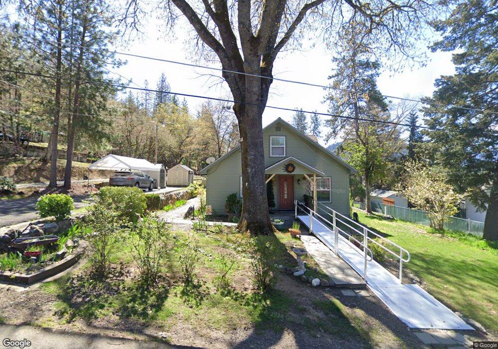
340 7th St Rogue River, OR 97537
Estimated Value: $338,000 - $436,000
3
Beds
1
Bath
1,570
Sq Ft
$237/Sq Ft
Est. Value
About This Home
This home is located at 340 7th St, Rogue River, OR 97537 and is currently estimated at $372,808, approximately $237 per square foot. 340 7th St is a home located in Jackson County with nearby schools including Rogue River Elementary School, South Valley Academy, and Rogue River Junior/Senior High School.
Ownership History
Date
Name
Owned For
Owner Type
Purchase Details
Closed on
Jul 1, 2009
Sold by
Torrel Mark N and Torrel Linda L
Bought by
Butcher Luther C and Butcher Kathleen M
Current Estimated Value
Home Financials for this Owner
Home Financials are based on the most recent Mortgage that was taken out on this home.
Original Mortgage
$167,750
Interest Rate
4.79%
Mortgage Type
Seller Take Back
Purchase Details
Closed on
Apr 22, 2004
Sold by
Bestul Elizabeth A and Estate Of Lauraine I Laws
Bought by
Torrel Mark N and Torrel Linda L
Purchase Details
Closed on
Dec 27, 1999
Sold by
Laws Lauraine I and Laws Lausaine I
Bought by
Bestul Elizabeth Ann
Purchase Details
Closed on
Aug 19, 1999
Sold by
Laws Lauraine I and Laws Elizabeth
Bought by
Bestul Elizabeth and Laws Ron
Create a Home Valuation Report for This Property
The Home Valuation Report is an in-depth analysis detailing your home's value as well as a comparison with similar homes in the area
Home Values in the Area
Average Home Value in this Area
Purchase History
| Date | Buyer | Sale Price | Title Company |
|---|---|---|---|
| Butcher Luther C | $202,750 | Ticor Title Company Of Or | |
| Torrel Mark N | $129,650 | Ticor Title | |
| Bestul Elizabeth Ann | -- | -- | |
| Bestul Elizabeth | -- | -- |
Source: Public Records
Mortgage History
| Date | Status | Borrower | Loan Amount |
|---|---|---|---|
| Closed | Butcher Luther C | $167,750 |
Source: Public Records
Tax History Compared to Growth
Tax History
| Year | Tax Paid | Tax Assessment Tax Assessment Total Assessment is a certain percentage of the fair market value that is determined by local assessors to be the total taxable value of land and additions on the property. | Land | Improvement |
|---|---|---|---|---|
| 2025 | $1,482 | $135,340 | $68,280 | $67,060 |
| 2024 | $1,482 | $131,400 | $66,290 | $65,110 |
| 2023 | $1,434 | $127,580 | $64,350 | $63,230 |
| 2022 | $1,400 | $127,580 | $64,350 | $63,230 |
| 2021 | $1,361 | $123,870 | $62,480 | $61,390 |
| 2020 | $1,326 | $120,270 | $60,650 | $59,620 |
| 2019 | $1,294 | $113,370 | $57,170 | $56,200 |
| 2018 | $1,260 | $110,070 | $55,510 | $54,560 |
| 2017 | $1,231 | $110,070 | $55,510 | $54,560 |
| 2016 | $1,201 | $103,760 | $52,320 | $51,440 |
| 2015 | $1,167 | $103,760 | $55,420 | $48,340 |
| 2014 | $1,129 | $97,810 | $52,250 | $45,560 |
Source: Public Records
Map
Nearby Homes
- 305 Woodville Way
- 300 Woodville Way
- 904 Broadway St Unit 503
- 815 Pine St Unit 10
- 4529 E Evans Creek Rd
- 105 Brolin Ct
- 0 Oak St
- 405 Magerle Ln
- 0 W Evans Creek Rd Unit 1000 220202360
- 0 W Evans Creek Rd Unit 1200 220202358
- 713 Brookside Cir
- 111 Cedar St
- 419 E Main St
- TL 1303 E Main St
- 299 Foothill Blvd
- 182 Wards Creek Rd
- 208 W Main St
- 2661 Wards Creek Rd
- 202 Arbor St
- 5830 Foothill Blvd