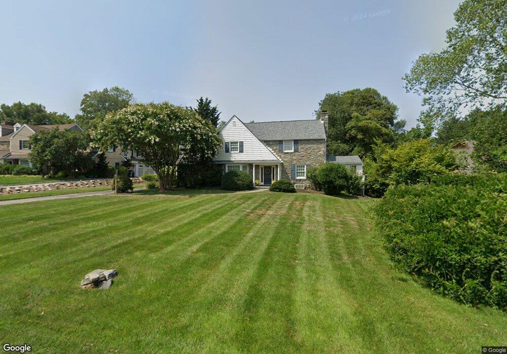
340 Ardmore Ave Ardmore, PA 19003
Estimated Value: $1,182,000 - $1,675,000
3
Beds
3
Baths
3,784
Sq Ft
$352/Sq Ft
Est. Value
About This Home
This home is located at 340 Ardmore Ave, Ardmore, PA 19003 and is currently estimated at $1,331,739, approximately $351 per square foot. 340 Ardmore Ave is a home located in Delaware County with nearby schools including Coopertown Elementary School, Haverford Middle School, and Haverford Senior High School.
Ownership History
Date
Name
Owned For
Owner Type
Purchase Details
Closed on
Aug 25, 1999
Sold by
Doughty Robert A
Bought by
Luntey John Kirk and Luntey Dorothy Fecht
Current Estimated Value
Home Financials for this Owner
Home Financials are based on the most recent Mortgage that was taken out on this home.
Original Mortgage
$292,800
Outstanding Balance
$85,456
Interest Rate
7.85%
Estimated Equity
$1,246,283
Create a Home Valuation Report for This Property
The Home Valuation Report is an in-depth analysis detailing your home's value as well as a comparison with similar homes in the area
Home Values in the Area
Average Home Value in this Area
Purchase History
| Date | Buyer | Sale Price | Title Company |
|---|---|---|---|
| Luntey John Kirk | $366,000 | T A Title Insurance Company |
Source: Public Records
Mortgage History
| Date | Status | Borrower | Loan Amount |
|---|---|---|---|
| Open | Luntey John Kirk | $292,800 |
Source: Public Records
Tax History Compared to Growth
Tax History
| Year | Tax Paid | Tax Assessment Tax Assessment Total Assessment is a certain percentage of the fair market value that is determined by local assessors to be the total taxable value of land and additions on the property. | Land | Improvement |
|---|---|---|---|---|
| 2025 | $16,207 | $630,320 | $233,460 | $396,860 |
| 2024 | $16,207 | $630,320 | $233,460 | $396,860 |
| 2023 | $15,747 | $630,320 | $233,460 | $396,860 |
| 2022 | $15,379 | $630,320 | $233,460 | $396,860 |
| 2021 | $25,054 | $630,320 | $233,460 | $396,860 |
| 2020 | $16,083 | $346,030 | $110,290 | $235,740 |
| 2019 | $15,786 | $346,030 | $110,290 | $235,740 |
| 2018 | $15,516 | $346,030 | $0 | $0 |
| 2017 | $15,187 | $346,030 | $0 | $0 |
| 2016 | $1,899 | $346,030 | $0 | $0 |
| 2015 | $1,899 | $346,030 | $0 | $0 |
| 2014 | $1,899 | $346,030 | $0 | $0 |
Source: Public Records
Map
Nearby Homes
- 133 Quaker Ln
- 201 Golf Hills Rd
- 210 218 David Dr
- 1901 Pennview Ave
- 345 Ellis Rd
- 128 Campbell Ave
- 139 Campbell Ave
- 2919 Morris Rd
- 109 Village Chatham Unit 109
- 26 E Turnbull Ave
- 2939 Berkley Rd
- 200 Marple Rd
- 5 W Turnbull Ave
- 231 Hastings Ave
- 128 Clemson Rd
- 2528 Rosemont Ave
- 421 E Eagle Rd
- 258 Lee Cir
- 6205 Parkview Dr
- 2814 Saint Marys Rd
- 336 Ardmore Ave
- 332 Ardmore Ave
- 1 Cambridge Rd
- 125 Quaker Ln
- 25 Cambridge Rd
- 326 Ardmore Ave
- 121 Quaker Ln
- 129 Quaker Ln
- 320 Ardmore Ave
- 31 Cambridge Rd
- 10 Cambridge Rd
- 314 Ardmore Ave
- 117 Quaker Ln
- 137 Quaker Ln
- 39 Cambridge Rd
- 315 Ardmore Ave
- 310 Ardmore Ave
- 350 Ardmore Ave
- 113 Quaker Ln
- 110 Quaker Ln