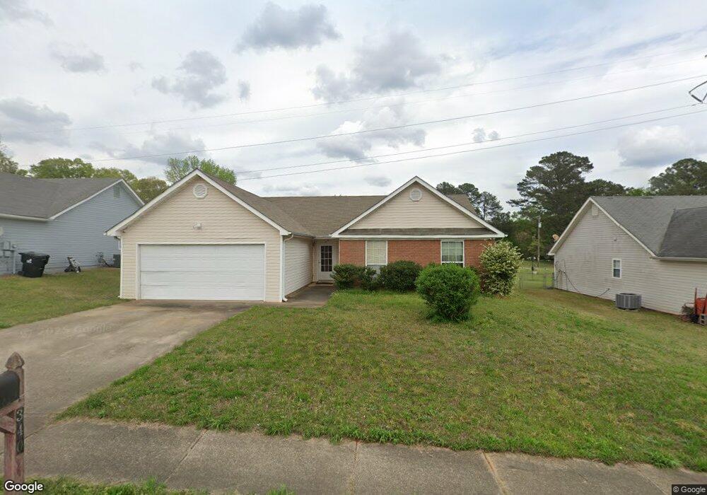
340 Brannans Ct McDonough, GA 30253
Estimated Value: $258,000 - $282,000
3
Beds
2
Baths
1,346
Sq Ft
$201/Sq Ft
Est. Value
About This Home
This home is located at 340 Brannans Ct, McDonough, GA 30253 and is currently estimated at $270,681, approximately $201 per square foot. 340 Brannans Ct is a home located in Henry County with nearby schools including Union Grove Middle School, Union Grove High School, and Hickory Flat Elementary School.
Ownership History
Date
Name
Owned For
Owner Type
Purchase Details
Closed on
Feb 3, 2020
Sold by
Taylor Aubrey E
Bought by
Mang Swe Hoe and Suunwe May
Current Estimated Value
Purchase Details
Closed on
Sep 9, 2015
Sold by
Taylor Aubrey E
Bought by
Taylor Aubrey E
Purchase Details
Closed on
Sep 30, 1998
Sold by
Cliftwood Cons Co Inc
Bought by
Taylor Aubrey and Taylor Evelyn
Create a Home Valuation Report for This Property
The Home Valuation Report is an in-depth analysis detailing your home's value as well as a comparison with similar homes in the area
Home Values in the Area
Average Home Value in this Area
Purchase History
| Date | Buyer | Sale Price | Title Company |
|---|---|---|---|
| Mang Swe Hoe | $157,000 | -- | |
| Taylor Aubrey E | -- | -- | |
| Taylor Aubrey | $90,000 | -- |
Source: Public Records
Tax History Compared to Growth
Tax History
| Year | Tax Paid | Tax Assessment Tax Assessment Total Assessment is a certain percentage of the fair market value that is determined by local assessors to be the total taxable value of land and additions on the property. | Land | Improvement |
|---|---|---|---|---|
| 2025 | $3,344 | $111,040 | $12,000 | $99,040 |
| 2024 | $3,344 | $108,360 | $12,000 | $96,360 |
| 2023 | $3,050 | $103,120 | $10,000 | $93,120 |
| 2022 | $2,751 | $81,440 | $10,000 | $71,440 |
| 2021 | $2,310 | $62,800 | $9,985 | $52,815 |
| 2020 | $742 | $56,720 | $8,000 | $48,720 |
| 2019 | $619 | $50,400 | $8,000 | $42,400 |
| 2018 | $0 | $49,120 | $8,000 | $41,120 |
| 2016 | $604 | $43,840 | $8,000 | $35,840 |
| 2015 | -- | $40,400 | $8,000 | $32,400 |
| 2014 | -- | $37,880 | $8,000 | $29,880 |
Source: Public Records
Map
Nearby Homes
- 248 Brannans Walk
- 209 Brannans Walk
- 796 Rock Ln
- 153 Rockport Dr
- 152 Rockport Dr
- 214 Kensington Trace
- 228 Kensington Trace
- 401 Crosshaven Way
- 200 Kensington Trace
- 248 Cranapple Ln
- 146 Himalaya Way
- 236 Himalaya Way
- 479 Crosshaven Way
- 1008 Carlyle Place
- 601 Sawgrass Walk
- 129 Talon Place
- 104 Riverside Close
- 1150 Strath Clyde Way
- 418 Abbey Springs Way
- 1125 Strath Clyde Way
- 344 Brannans Ct
- 336 Brannans Ct
- 348 Brannans Ct
- 348 Brannans Ct Unit 1
- 332 Brannans Ct
- 339 Brannans Ct
- 343 Brannans Ct
- 335 Brannans Ct
- 352 Brannans Ct
- 328 Brannans Ct
- 347 Brannans Ct
- 1690 Brannan Rd
- 325 Brannans Ct
- 351 Brannans Ct
- 324 Brannans Ct Unit 45
- 324 Brannans Ct
- 315 Brannans Ct
- 356 Brannans Ct
- 360 Brannans Ct 0
- 320 Brannans Ct