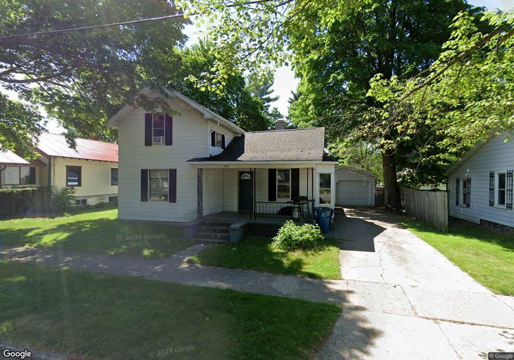
340 E Dayton St Fremont, MI 49412
Estimated Value: $166,727 - $200,000
Studio
--
Bath
--
Sq Ft
8,712
Sq Ft Lot
About This Home
This home is located at 340 E Dayton St, Fremont, MI 49412 and is currently estimated at $179,932. 340 E Dayton St is a home located in Newaygo County with nearby schools including Daisy Brook Elementary School, Pathfinder Elementary School, and Quest High School.
Ownership History
Date
Name
Owned For
Owner Type
Purchase Details
Closed on
Jun 6, 2018
Sold by
How Kara P
Bought by
How Christopher L
Current Estimated Value
Purchase Details
Closed on
Jul 29, 2011
Sold by
Zeerip William J and Zeerip Betsy
Bought by
How Christopher
Home Financials for this Owner
Home Financials are based on the most recent Mortgage that was taken out on this home.
Original Mortgage
$60,103
Interest Rate
4.53%
Mortgage Type
Purchase Money Mortgage
Purchase Details
Closed on
Dec 15, 2010
Sold by
Oosterhouse Ann M and Oosterhouse David B
Bought by
Zeerip William J and Zeerip Betsy
Create a Home Valuation Report for This Property
The Home Valuation Report is an in-depth analysis detailing your home's value as well as a comparison with similar homes in the area
Home Values in the Area
Average Home Value in this Area
Purchase History
| Date | Buyer | Sale Price | Title Company |
|---|---|---|---|
| How Christopher L | -- | -- | |
| How Christopher | -- | -- | |
| Zeerip William J | $20,000 | -- |
Source: Public Records
Mortgage History
| Date | Status | Borrower | Loan Amount |
|---|---|---|---|
| Previous Owner | How Christopher | $60,103 |
Source: Public Records
Tax History
| Year | Tax Paid | Tax Assessment Tax Assessment Total Assessment is a certain percentage of the fair market value that is determined by local assessors to be the total taxable value of land and additions on the property. | Land | Improvement |
|---|---|---|---|---|
| 2025 | $1,786 | $76,900 | $0 | $0 |
| 2024 | $16 | $70,200 | $0 | $0 |
| 2023 | $1,057 | $62,100 | $0 | $0 |
| 2022 | $1,332 | $56,200 | $0 | $0 |
| 2021 | $1,283 | $51,100 | $0 | $0 |
| 2020 | $1,265 | $51,200 | $0 | $0 |
| 2019 | $1,214 | $46,700 | $0 | $0 |
| 2018 | $1,188 | $31,300 | $0 | $0 |
| 2017 | $1,208 | $29,800 | $0 | $0 |
| 2016 | $1,077 | $27,500 | $0 | $0 |
| 2015 | -- | $25,800 | $0 | $0 |
| 2014 | -- | $24,100 | $0 | $0 |
Source: Public Records
Map
Nearby Homes
- 383 Pinery Ln
- 385 Pinery Ln
- 387 Pinery Ln
- 116 E Sheridan St
- 412 N Darling Ave
- 356 Birch St
- 601 E Oak St
- 217 Southwoods Ave
- 616 S Stewart Ave
- 531 Seminole Dr
- 415 Vista Ln
- 406 Vienna Ln
- 203 Baden Place
- 514 Vista Ln
- 5034 W 48th St
- 5230 S Columbine Ln
- 518 S Sullivan Ave
- 5229 Lilac Ln
- 4154 Sunset Dr
- 813 Valley Ave
- 336 E Dayton St
- 346 E Dayton St
- 21 N Decker Ave
- 328 E Dayton St
- 339 E Main St
- 25 N Decker Ave
- 345 E Main St
- 333 E Main St
- 322 E Dayton St
- 339 E Dayton St
- 5 N Decker Ave
- 333 E Dayton St
- 345 E Dayton St
- 321 N Decker Ave
- 329 E Dayton St
- 18 N Decker Ave
- 24 N Decker Ave
- 323 E Main St
- 321 E Dayton St
- 717 E Main St
Your Personal Tour Guide
Ask me questions while you tour the home.