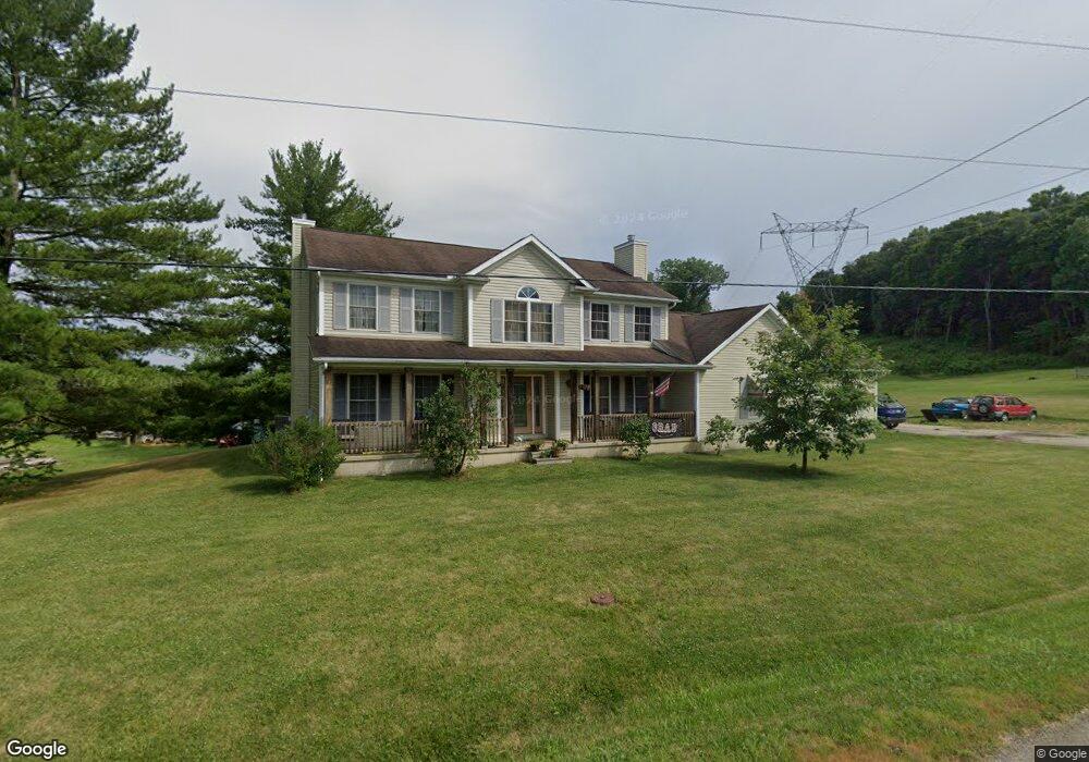
340 Mount Carmel Rd Chillicothe, OH 45601
Estimated Value: $412,000 - $586,047
6
Beds
5
Baths
3,612
Sq Ft
$146/Sq Ft
Est. Value
About This Home
This home is located at 340 Mount Carmel Rd, Chillicothe, OH 45601 and is currently estimated at $528,016, approximately $146 per square foot. 340 Mount Carmel Rd is a home located in Ross County with nearby schools including Unioto Elementary School, Unioto Middle School, and Unioto High School.
Ownership History
Date
Name
Owned For
Owner Type
Purchase Details
Closed on
May 16, 2019
Sold by
Estate Of Michael E Buchanan
Bought by
Ooten Donald B
Current Estimated Value
Purchase Details
Closed on
Mar 8, 2011
Sold by
Buchanan Michael E
Bought by
Buchanan Michael E
Purchase Details
Closed on
Feb 2, 2011
Sold by
Buchanan Michael E and Ooten Donald B
Bought by
Buchanan Michael E and Ooten Donald B
Purchase Details
Closed on
May 30, 2007
Sold by
Ooten Donald B and Ooten Alyssa B
Bought by
Buchanan Michael E and Ooten Donald B
Home Financials for this Owner
Home Financials are based on the most recent Mortgage that was taken out on this home.
Original Mortgage
$241,200
Interest Rate
6.21%
Mortgage Type
Purchase Money Mortgage
Purchase Details
Closed on
Feb 9, 2007
Sold by
Clark Dustin C
Bought by
Ooten Donald B and Ooten Alyssa B
Create a Home Valuation Report for This Property
The Home Valuation Report is an in-depth analysis detailing your home's value as well as a comparison with similar homes in the area
Home Values in the Area
Average Home Value in this Area
Purchase History
| Date | Buyer | Sale Price | Title Company |
|---|---|---|---|
| Ooten Donald B | -- | None Available | |
| Buchanan Michael E | -- | Attorney | |
| Buchanan Michael E | -- | Attorney | |
| Buchanan Michael E | $6,400 | Americas Choice Title Agency | |
| Ooten Donald B | $32,000 | Attorney |
Source: Public Records
Mortgage History
| Date | Status | Borrower | Loan Amount |
|---|---|---|---|
| Previous Owner | Buchanan Michael E | $241,200 |
Source: Public Records
Tax History Compared to Growth
Tax History
| Year | Tax Paid | Tax Assessment Tax Assessment Total Assessment is a certain percentage of the fair market value that is determined by local assessors to be the total taxable value of land and additions on the property. | Land | Improvement |
|---|---|---|---|---|
| 2024 | $5,688 | $164,810 | $10,450 | $154,360 |
| 2023 | $5,688 | $164,810 | $10,450 | $154,360 |
| 2022 | $5,813 | $164,810 | $10,450 | $154,360 |
| 2021 | $4,575 | $121,420 | $5,750 | $115,670 |
| 2020 | $4,600 | $121,420 | $5,750 | $115,670 |
| 2019 | $4,268 | $121,420 | $5,750 | $115,670 |
| 2018 | $3,877 | $109,040 | $5,430 | $103,610 |
| 2017 | $3,882 | $109,040 | $5,430 | $103,610 |
| 2016 | $3,783 | $109,040 | $5,430 | $103,610 |
| 2015 | $3,495 | $100,580 | $5,430 | $95,150 |
| 2014 | $3,411 | $100,580 | $5,430 | $95,150 |
| 2013 | $3,427 | $116,800 | $5,430 | $111,370 |
Source: Public Records
Map
Nearby Homes
- 435 Mount Carmel Rd
- 10217 County Road 550
- 420 Steiner Rd
- 54 Moccasin Dr
- 11303 County Road 550
- 313 Goodale Dr
- 2719 Sulphur Lick Rd
- 365 Golfview Dr
- 16383 State Route 28
- 102 Franklin Cir
- 18 Sarah Ct
- 12690 Pleasant Valley Rd
- 2083 Anderson Station Rd
- 1036 Clinton Rd
- 13223 Pleasant Valley Rd
- 265 Brookside Dr
- 2153 Egypt Pike
- 320 Summerhill Dr
- 25 Woodland Way
- 45 Custer Dr
- 396 Mount Carmel Rd
- 391 Mount Carmel Rd
- 474 Mount Carmel Rd
- 343 Mount Carmel Rd
- 240 Mount Carmel Rd
- 265 Mount Carmel Rd
- 181 Mount Carmel Rd
- 157 Mount Carmel Rd
- 231 Mount Carmel Rd
- 85 Mount Carmel Rd
- 80 Mount Carmel Rd
- 24 Mount Carmel Rd
- 3510 Maple Grove Rd
- 3480 Maple Grove Rd
- 3020 Maple Grove Rd
- 3549 Maple Grove Rd
- 3152 Maple Grove Rd
- 3206 Maple Grove Rd
- 3671 Maple Grove Rd