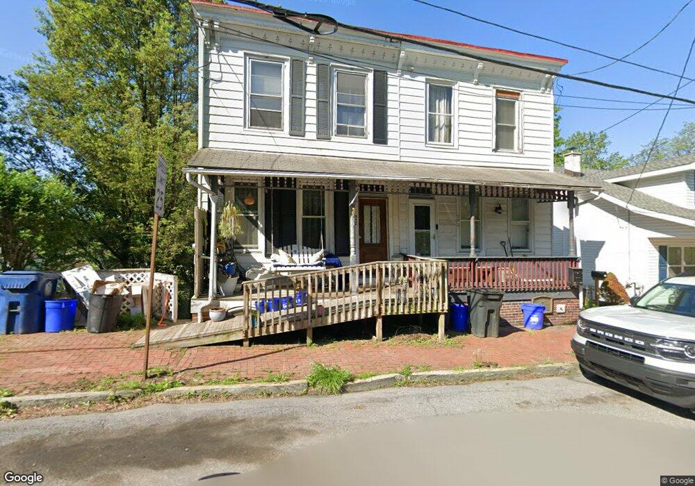
340 Port Clinton Ave Hamburg, PA 19526
Estimated Value: $164,000 - $196,154
2
Beds
2
Baths
1,088
Sq Ft
$161/Sq Ft
Est. Value
About This Home
This home is located at 340 Port Clinton Ave, Hamburg, PA 19526 and is currently estimated at $175,289, approximately $161 per square foot. 340 Port Clinton Ave is a home located in Berks County with nearby schools including Hamburg Area High School, Blue Mountain Seventh-day Adventist Elementary School, and Blue Mountain Academy.
Ownership History
Date
Name
Owned For
Owner Type
Purchase Details
Closed on
Apr 29, 2020
Sold by
Hinkle Leroy H and Hinkle M Vasilia E
Bought by
Fisher Samantha A
Current Estimated Value
Home Financials for this Owner
Home Financials are based on the most recent Mortgage that was taken out on this home.
Original Mortgage
$77,176
Outstanding Balance
$68,769
Interest Rate
3.6%
Mortgage Type
FHA
Estimated Equity
$106,520
Purchase Details
Closed on
Mar 20, 1986
Bought by
Hinkle Leroy H and Hinkle Vasilia E
Create a Home Valuation Report for This Property
The Home Valuation Report is an in-depth analysis detailing your home's value as well as a comparison with similar homes in the area
Home Values in the Area
Average Home Value in this Area
Purchase History
| Date | Buyer | Sale Price | Title Company |
|---|---|---|---|
| Fisher Samantha A | $78,600 | North Alabama T&E | |
| Hinkle Leroy H | -- | -- |
Source: Public Records
Mortgage History
| Date | Status | Borrower | Loan Amount |
|---|---|---|---|
| Open | Fisher Samantha A | $77,176 |
Source: Public Records
Tax History Compared to Growth
Tax History
| Year | Tax Paid | Tax Assessment Tax Assessment Total Assessment is a certain percentage of the fair market value that is determined by local assessors to be the total taxable value of land and additions on the property. | Land | Improvement |
|---|---|---|---|---|
| 2025 | $1,113 | $61,800 | $20,800 | $41,000 |
| 2024 | $2,738 | $61,800 | $20,800 | $41,000 |
| 2023 | $2,665 | $61,800 | $20,800 | $41,000 |
| 2022 | $2,665 | $61,800 | $20,800 | $41,000 |
| 2021 | $2,649 | $61,800 | $20,800 | $41,000 |
| 2020 | $2,649 | $61,800 | $20,800 | $41,000 |
| 2019 | $2,634 | $61,800 | $20,800 | $41,000 |
| 2018 | $2,634 | $61,800 | $20,800 | $41,000 |
| 2017 | $2,601 | $61,800 | $20,800 | $41,000 |
| 2016 | $931 | $61,800 | $20,800 | $41,000 |
| 2015 | $931 | $61,800 | $20,800 | $41,000 |
| 2014 | $931 | $61,800 | $20,800 | $41,000 |
Source: Public Records
Map
Nearby Homes
- 332 Port Clinton Ave
- 338 Port Clinton Ave
- 344 Port Clinton Ave
- 330 Port Clinton Ave
- 350 Port Clinton Ave
- 326 Port Clinton Ave
- 324 Port Clinton Ave
- 320 Port Clinton Ave
- 318 Port Clinton Ave
- 316 Port Clinton Ave
- 314 Port Clinton Ave
- 308 Port Clinton Ave
- 319 Port Clinton Ave
- 313 Port Clinton Ave
- 311 Port Clinton Ave
- 306 Port Clinton Ave
- 262 N Peach Aly
- 304 Port Clinton Ave
- 258 N 3rd St
- 267 Port Clinton Ave