K
Seller's Agent in 2014
Keith MacDonald
Prudent Real Estate Associates


Estimated Value: $308,986 - $430,000
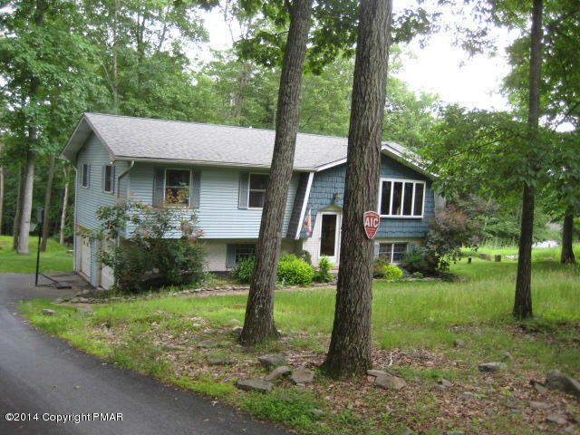
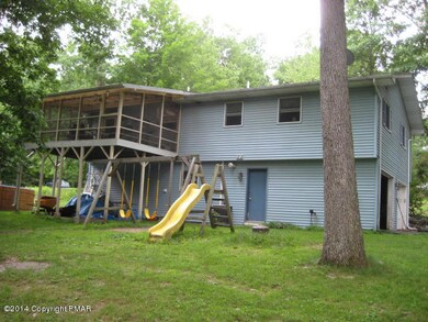
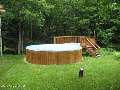
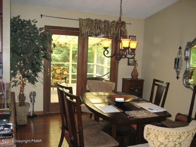
This place has it all, over an acre of land, central air, propane heat in ground utilities, a/g swimming pool with deck, beautiful screened in porch, 2 car garage, paved driveway, family room, new carpet, new furnice, new hot water heater, newer roof, some stainlees steel appliances, new carpets, kitchen has upgraded cabinets, tiled floor and recessed lighting, tiled bath with 2 sinks.
Last Agent to Sell the Property
Keith MacDonald
Prudent Real Estate Associates License #AB065425 Listed on: 06/30/2014
Last Buyer's Agent
Sharon Ace
McKeown Real Estate License #RS205863L
| Date | Buyer | Sale Price | Title Company |
|---|---|---|---|
| Ventre Charles J | $169,900 | None Available | |
| Sainz Sharon | -- | None Available | |
| Probert Kristen | -- | None Available |
| Date | Status | Borrower | Loan Amount |
|---|---|---|---|
| Open | Ventre Charles J | $161,405 |
| Date | Event | Price | List to Sale | Price per Sq Ft |
|---|---|---|---|---|
| 10/10/2014 10/10/14 | Sold | $131,000 | -5.8% | $68 / Sq Ft |
| 08/26/2014 08/26/14 | Pending | -- | -- | -- |
| 06/28/2014 06/28/14 | For Sale | $139,000 | -- | $72 / Sq Ft |
| Year | Tax Paid | Tax Assessment Tax Assessment Total Assessment is a certain percentage of the fair market value that is determined by local assessors to be the total taxable value of land and additions on the property. | Land | Improvement |
|---|---|---|---|---|
| 2025 | $1,337 | $157,730 | $13,670 | $144,060 |
| 2024 | $1,100 | $157,730 | $13,670 | $144,060 |
| 2023 | $5,601 | $157,730 | $13,670 | $144,060 |
| 2022 | $5,594 | $157,730 | $13,670 | $144,060 |
| 2021 | $5,478 | $157,730 | $13,670 | $144,060 |
| 2020 | $5,122 | $157,730 | $13,670 | $144,060 |
| 2019 | $4,615 | $22,600 | $4,000 | $18,600 |
| 2018 | $4,615 | $22,600 | $4,000 | $18,600 |
| 2017 | $4,615 | $22,600 | $4,000 | $18,600 |
| 2016 | $4,188 | $22,600 | $4,000 | $18,600 |
| 2015 | -- | $22,600 | $4,000 | $18,600 |
| 2014 | -- | $22,600 | $4,000 | $18,600 |
K
Seller's Agent in 2014
Keith MacDonald
Prudent Real Estate Associates
S
Buyer's Agent in 2014
Sharon Ace
McKeown Real Estate
Source: Pocono Mountains Association of REALTORS®
MLS Number: PM-13834
APN: 16.7B.3.26
Disclaimer: Certain information contained herein is derived from information provided by parties other than Homes.com. All information provided is deemed reliable, but is not guaranteed to be accurate and should be independently verified.
![]() The data relating to real estate for sale on this web site includes listings held by MLS-IDX Participants of the Internet Data Exchange program of the Multiple Listing Service of the Pocono Mountains Association of Realtors®. Listings marked with the Internet Data Exchange logo are not necessarilty the listings of the owner of this web site. All listing data is the copyrighted property of the aforesaid Associations and its MLS-IDX Participants with all rights reserved. The information contained herein is believed to be accurate, but no warranty as such is expressed or implied.
The data relating to real estate for sale on this web site includes listings held by MLS-IDX Participants of the Internet Data Exchange program of the Multiple Listing Service of the Pocono Mountains Association of Realtors®. Listings marked with the Internet Data Exchange logo are not necessarilty the listings of the owner of this web site. All listing data is the copyrighted property of the aforesaid Associations and its MLS-IDX Participants with all rights reserved. The information contained herein is believed to be accurate, but no warranty as such is expressed or implied.
