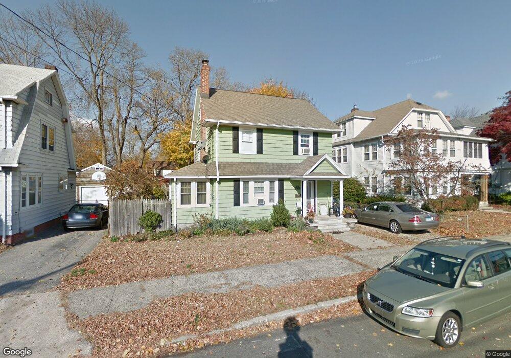
340 Wade St Bridgeport, CT 06604
Brooklawn-Saint Vincent NeighborhoodEstimated Value: $321,000 - $449,000
3
Beds
2
Baths
1,697
Sq Ft
$237/Sq Ft
Est. Value
About This Home
This home is located at 340 Wade St, Bridgeport, CT 06604 and is currently estimated at $402,709, approximately $237 per square foot. 340 Wade St is a home located in Fairfield County with nearby schools including Geraldine Johnson School, Bassick High School, and Catholic Academy of Bridgeport-St. Raphael Academy.
Ownership History
Date
Name
Owned For
Owner Type
Purchase Details
Closed on
Nov 28, 2011
Sold by
Rider Allan
Bought by
Campos Ernando
Current Estimated Value
Create a Home Valuation Report for This Property
The Home Valuation Report is an in-depth analysis detailing your home's value as well as a comparison with similar homes in the area
Home Values in the Area
Average Home Value in this Area
Purchase History
| Date | Buyer | Sale Price | Title Company |
|---|---|---|---|
| Campos Ernando | $153,000 | -- | |
| Campos Ernando | $153,000 | -- |
Source: Public Records
Mortgage History
| Date | Status | Borrower | Loan Amount |
|---|---|---|---|
| Previous Owner | Campos Ernando | $180,800 | |
| Previous Owner | Campos Ernando | $135,000 |
Source: Public Records
Tax History Compared to Growth
Tax History
| Year | Tax Paid | Tax Assessment Tax Assessment Total Assessment is a certain percentage of the fair market value that is determined by local assessors to be the total taxable value of land and additions on the property. | Land | Improvement |
|---|---|---|---|---|
| 2025 | $6,968 | $160,370 | $78,710 | $81,660 |
| 2024 | $6,968 | $160,370 | $78,710 | $81,660 |
| 2023 | $6,968 | $160,370 | $78,710 | $81,660 |
| 2022 | $6,968 | $160,370 | $78,710 | $81,660 |
| 2021 | $6,968 | $160,370 | $78,710 | $81,660 |
| 2020 | $6,756 | $125,130 | $47,690 | $77,440 |
| 2019 | $6,756 | $125,130 | $47,690 | $77,440 |
| 2018 | $6,803 | $125,130 | $47,690 | $77,440 |
| 2017 | $6,803 | $125,130 | $47,690 | $77,440 |
| 2016 | $6,803 | $125,130 | $47,690 | $77,440 |
| 2015 | $6,629 | $157,080 | $52,900 | $104,180 |
| 2014 | $6,629 | $157,080 | $52,900 | $104,180 |
Source: Public Records
Map
Nearby Homes
- 665 W Taft Ave
- 184 Pacific St
- 1213 Wood Ave
- 687 Wood Ave
- 605 Brooklawn Ave
- 860 Briarwood Ave
- 1872 North Ave Unit 1874
- 1480 Capitol Ave Unit 811
- 2370 North Ave Unit 4C
- 2370 North Ave Unit 12G
- 2370 North Ave Unit 3F
- 566 Wood Ave
- 2345 Park Ave
- 356 Taft Ave
- 80 Cartright St Unit 8J
- 80 Cartright St Unit 2F
- 80 Cartright St Unit GC
- 80 Cartright St Unit 8B
- 80 Cartright St Unit GFA
- 100 Lorraine St