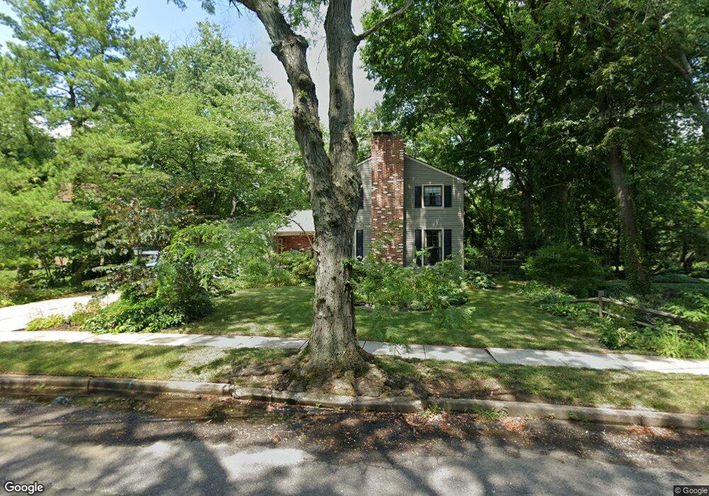
340 Wayland Rd Cherry Hill, NJ 08034
Estimated Value: $496,133 - $589,000
--
Bed
--
Bath
2,056
Sq Ft
$264/Sq Ft
Est. Value
About This Home
This home is located at 340 Wayland Rd, Cherry Hill, NJ 08034 and is currently estimated at $542,283, approximately $263 per square foot. 340 Wayland Rd is a home located in Camden County with nearby schools including A. Russell Knight Elementary School, John A Carusi Middle School, and Cherry Hill High-West High School.
Ownership History
Date
Name
Owned For
Owner Type
Purchase Details
Closed on
Apr 25, 2012
Sold by
Mcguire Joseph A and Mcguire Elizabeth M
Bought by
Sweeney Jennifer and Sweeney Scott
Current Estimated Value
Home Financials for this Owner
Home Financials are based on the most recent Mortgage that was taken out on this home.
Original Mortgage
$253,409
Outstanding Balance
$174,334
Interest Rate
3.75%
Mortgage Type
FHA
Estimated Equity
$367,949
Purchase Details
Closed on
Dec 7, 1990
Bought by
Rowland Charles and Pamela Jo
Create a Home Valuation Report for This Property
The Home Valuation Report is an in-depth analysis detailing your home's value as well as a comparison with similar homes in the area
Home Values in the Area
Average Home Value in this Area
Purchase History
| Date | Buyer | Sale Price | Title Company |
|---|---|---|---|
| Sweeney Jennifer | $260,000 | American Home Title Ag | |
| Rowland Charles | $160,000 | -- |
Source: Public Records
Mortgage History
| Date | Status | Borrower | Loan Amount |
|---|---|---|---|
| Open | Sweeney Jennifer | $253,409 |
Source: Public Records
Tax History Compared to Growth
Tax History
| Year | Tax Paid | Tax Assessment Tax Assessment Total Assessment is a certain percentage of the fair market value that is determined by local assessors to be the total taxable value of land and additions on the property. | Land | Improvement |
|---|---|---|---|---|
| 2025 | $10,644 | $238,700 | $67,900 | $170,800 |
| 2024 | $10,030 | $238,700 | $67,900 | $170,800 |
| 2023 | $10,030 | $238,700 | $67,900 | $170,800 |
| 2022 | $9,753 | $238,700 | $67,900 | $170,800 |
| 2021 | $9,784 | $238,700 | $67,900 | $170,800 |
| 2020 | $9,665 | $238,700 | $67,900 | $170,800 |
| 2019 | $9,660 | $238,700 | $67,900 | $170,800 |
| 2018 | $9,634 | $238,700 | $67,900 | $170,800 |
| 2017 | $9,503 | $238,700 | $67,900 | $170,800 |
| 2016 | $9,376 | $238,700 | $67,900 | $170,800 |
| 2015 | $9,228 | $238,700 | $67,900 | $170,800 |
| 2014 | $9,126 | $238,700 | $67,900 | $170,800 |
Source: Public Records
Map
Nearby Homes
- 217 Redstone Ridge
- 110 Barclay Ln
- 205 E Tampa Ave
- 1111 Barclay Towers
- 916 Edgemoor Rd
- 917 Deland Ave
- 1007 Chelten Pkwy
- 19 Montana Ave
- 111 W Miami Ave
- 4514 Champions Run Unit 4514
- 16 Churchill Rd
- 115 Edison Rd
- 124 Edison Rd
- 406 Pennsylvania Ave
- 145 Park Dr
- 130 Pearl Croft Rd
- 625 Jefferson Ave
- 203 Rhode Island Ave
- 6 Queens Place
- 223 W Miami Ave
- 336 Wayland Rd
- 350 Wayland Rd
- 332 Wayland Rd
- 335 Wayland Rd
- 345 Wayland Rd
- 360 Wayland Rd
- 328 Wayland Rd
- 325 Marlton Pike E
- 315 Marlton Pike E
- 100 Westover Dr
- 8 Briar Rd
- 323 Wayland Rd
- 370 Wayland Rd
- 324 Wayland Rd
- 104 Westover Dr
- 10 Briar Rd
- 6 Briar Rd
- 108 Westover Dr
- 305 Marlton Pike E
- 305 New Jersey 70