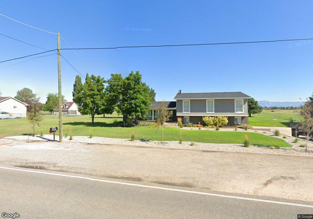
3400 W 1700 S Syracuse, UT 84075
Estimated Value: $619,000 - $732,000
4
Beds
3
Baths
3,894
Sq Ft
$177/Sq Ft
Est. Value
About This Home
This home is located at 3400 W 1700 S, Syracuse, UT 84075 and is currently estimated at $690,458, approximately $177 per square foot. 3400 W 1700 S is a home located in Davis County with nearby schools including Buffalo Point School, Syracuse Junior High School, and Syracuse High School.
Ownership History
Date
Name
Owned For
Owner Type
Purchase Details
Closed on
May 14, 2024
Sold by
Cook Clint and Cook Aimee A
Bought by
Fsp10 Sunquest 2 Llc
Current Estimated Value
Purchase Details
Closed on
Jan 5, 2017
Sold by
Cook Clinton
Bought by
Cook Clinton and Cook Aimee A
Home Financials for this Owner
Home Financials are based on the most recent Mortgage that was taken out on this home.
Original Mortgage
$310,337
Interest Rate
4.4%
Mortgage Type
FHA
Purchase Details
Closed on
Dec 2, 1998
Sold by
Blackburn Jones Real Estate Inc
Bought by
Hammon Daniel L and Hammon Courtney D
Create a Home Valuation Report for This Property
The Home Valuation Report is an in-depth analysis detailing your home's value as well as a comparison with similar homes in the area
Home Values in the Area
Average Home Value in this Area
Purchase History
| Date | Buyer | Sale Price | Title Company |
|---|---|---|---|
| Fsp10 Sunquest 2 Llc | -- | First American Title | |
| Cook Clinton | -- | Cottonwood Title | |
| Cook Clinton | -- | Backman Title | |
| Hammon Daniel L | -- | First American Title Co |
Source: Public Records
Mortgage History
| Date | Status | Borrower | Loan Amount |
|---|---|---|---|
| Previous Owner | Cook Clinton | $310,337 |
Source: Public Records
Tax History Compared to Growth
Tax History
| Year | Tax Paid | Tax Assessment Tax Assessment Total Assessment is a certain percentage of the fair market value that is determined by local assessors to be the total taxable value of land and additions on the property. | Land | Improvement |
|---|---|---|---|---|
| 2025 | $3,917 | $377,916 | $141,958 | $235,958 |
| 2024 | $3,766 | $365,803 | $143,954 | $221,849 |
| 2023 | $3,559 | $629,000 | $181,903 | $447,097 |
| 2022 | $3,831 | $371,250 | $109,021 | $262,229 |
| 2021 | $3,280 | $492,000 | $156,413 | $335,587 |
| 2020 | $2,885 | $419,000 | $148,984 | $270,016 |
| 2019 | $2,783 | $399,000 | $139,567 | $259,433 |
| 2018 | $2,680 | $360,000 | $154,782 | $205,218 |
| 2016 | $2,448 | $182,946 | $75,611 | $107,335 |
| 2015 | $2,261 | $160,891 | $75,611 | $85,280 |
Source: Public Records
Map
Nearby Homes
- 1430 Heather Ln
- 3478 Brookshire Dr
- 2982 S 3000 W
- 2912 S 3000 W
- 3704 W 2170 S Unit 111
- 3360 W 2280 S
- 3867 Rungsted Cir
- 3951 Baltimore Cir
- 2840 W 1200 S
- 2679 W Antelope Dr
- 2961 S 2425 W Unit 1123
- 4191 W 1425 S
- 851 S 3525 W
- 895 Dunes Dr
- 3565 W 800 S
- 3661 W 800 S
- 1084 S 4090 W
- 2524 S 3590 W Unit 602
- 2965 S 3000 W
- 2971 S 2425 W Unit 1124