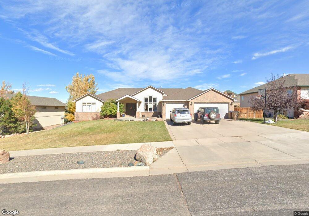
3405 Reynolds St Laramie, WY 82072
Estimated Value: $561,000 - $719,140
5
Beds
4
Baths
2,572
Sq Ft
$257/Sq Ft
Est. Value
About This Home
This home is located at 3405 Reynolds St, Laramie, WY 82072 and is currently estimated at $660,047, approximately $256 per square foot. 3405 Reynolds St is a home located in Albany County with nearby schools including Indian Paintbrush Elementary School, Laramie Middle School, and Laramie High School.
Ownership History
Date
Name
Owned For
Owner Type
Purchase Details
Closed on
Jun 29, 2021
Sold by
Manwarren Sarah Jean and Manwarren Jason
Bought by
Mclean Travis Martin and Park Joanne
Current Estimated Value
Home Financials for this Owner
Home Financials are based on the most recent Mortgage that was taken out on this home.
Original Mortgage
$499,000
Outstanding Balance
$452,973
Interest Rate
2.93%
Mortgage Type
New Conventional
Estimated Equity
$207,074
Purchase Details
Closed on
Feb 1, 2017
Sold by
Harding Ronald W and Harding Ronda R
Bought by
Manwarren Sarah Jean and Manwarren Jason
Home Financials for this Owner
Home Financials are based on the most recent Mortgage that was taken out on this home.
Original Mortgage
$71,250
Interest Rate
4.3%
Mortgage Type
Credit Line Revolving
Create a Home Valuation Report for This Property
The Home Valuation Report is an in-depth analysis detailing your home's value as well as a comparison with similar homes in the area
Home Values in the Area
Average Home Value in this Area
Purchase History
| Date | Buyer | Sale Price | Title Company |
|---|---|---|---|
| Mclean Travis Martin | -- | First American Title | |
| Manwarren Sarah Jean | -- | First American Title |
Source: Public Records
Mortgage History
| Date | Status | Borrower | Loan Amount |
|---|---|---|---|
| Open | Mclean Travis Martin | $499,000 | |
| Previous Owner | Manwarren Sarah Jean | $71,250 |
Source: Public Records
Tax History Compared to Growth
Tax History
| Year | Tax Paid | Tax Assessment Tax Assessment Total Assessment is a certain percentage of the fair market value that is determined by local assessors to be the total taxable value of land and additions on the property. | Land | Improvement |
|---|---|---|---|---|
| 2021 | $3,829 | $52,452 | $8,118 | $44,334 |
| 2020 | $3,452 | $47,284 | $8,533 | $38,751 |
| 2019 | $3,375 | $46,226 | $8,453 | $37,773 |
| 2018 | $3,417 | $46,804 | $8,453 | $38,351 |
| 2017 | $3,414 | $46,763 | $8,155 | $38,608 |
| 2016 | $3,218 | $44,084 | $8,155 | $35,929 |
| 2015 | $3,197 | $43,792 | $7,030 | $36,762 |
| 2014 | $3,174 | $43,474 | $0 | $0 |
Source: Public Records
Map
Nearby Homes
- TBD Hayford Ave
- 1772 Eaglecrest Ct
- 1651 Fox Ridge Rd
- 3734 Reynolds St
- 1071 Duna Dr
- 1062 Bonita Dr
- 2919 Plains St
- 2719 Nighthawk Dr
- 2611 Reynolds St Unit A
- 4106 Kiowa Dr
- 1050 N Indian Hills Dr
- 1766 N 23rd St
- 4341 E Crow Dr
- 4324 Pueblo Dr
- 4421 Shoshone Dr
- 2122 E Curtis St
- 1554 Henry Dr
- 1150 N 18th St
- 1520 W Hill Rd
- 2167 N 16th St
- 3415 Reynolds St
- 3410 Hayford Ave
- 3321 Reynolds St
- 3402 Hayford Ave
- 3416 Hayford Ave
- 3402 Reynolds St
- 3509 Reynolds St
- 3320 Hayford Ave
- 3412 Reynolds St
- 3512 Hayford Ave
- 3318 Reynolds St
- 3313 Reynolds St
- 3505 Hayford Ave
- 3404 Mammoth Ct
- 3314 Reynolds St
- 3410 Mammoth Ct
- 3508 Reynolds St
- 3310 Hayford Ave
- 3307 Reynolds St
- 3221 Reynolds St