Estimated Value: $507,000 - $543,875
4
Beds
3
Baths
3,691
Sq Ft
$143/Sq Ft
Est. Value
About This Home
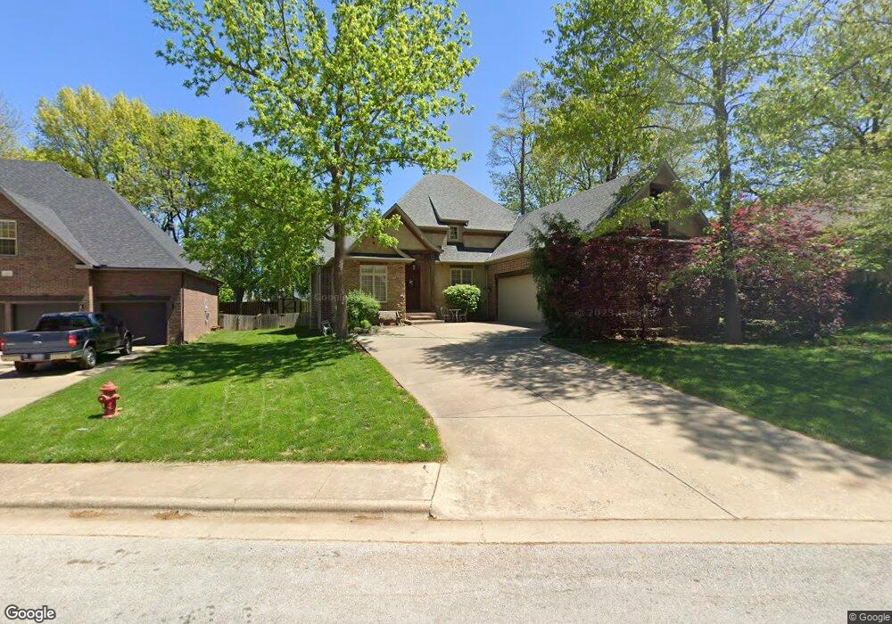
This home is located at 3406 N 10th St, Ozark, MO 65721 and is currently estimated at $526,969, approximately $142 per square foot. 3406 N 10th St is a home located in Christian County with nearby schools including North Elementary School, Ozark Middle School, and Ozark Junior High School.
Ownership History
Date
Name
Owned For
Owner Type
Purchase Details
Closed on
Jan 30, 2012
Sold by
Pitchford Mark
Bought by
Gillion Dallas and Gillion Heather
Current Estimated Value
Home Financials for this Owner
Home Financials are based on the most recent Mortgage that was taken out on this home.
Original Mortgage
$216,000
Outstanding Balance
$146,608
Interest Rate
4%
Mortgage Type
New Conventional
Estimated Equity
$380,361
Purchase Details
Closed on
Sep 2, 2005
Sold by
Pitchford Custom Homes Inc
Bought by
Pitchford Mark
Create a Home Valuation Report for This Property
The Home Valuation Report is an in-depth analysis detailing your home's value as well as a comparison with similar homes in the area
Home Values in the Area
Average Home Value in this Area
Purchase History
| Date | Buyer | Sale Price | Title Company |
|---|---|---|---|
| Gillion Dallas | -- | Meridian Title Company] | |
| Pitchford Mark | -- | None Available |
Source: Public Records
Mortgage History
| Date | Status | Borrower | Loan Amount |
|---|---|---|---|
| Open | Gillion Dallas | $216,000 |
Source: Public Records
Tax History
| Year | Tax Paid | Tax Assessment Tax Assessment Total Assessment is a certain percentage of the fair market value that is determined by local assessors to be the total taxable value of land and additions on the property. | Land | Improvement |
|---|---|---|---|---|
| 2025 | $3,961 | $67,370 | -- | -- |
| 2024 | $3,956 | $63,290 | -- | -- |
| 2023 | $3,956 | $63,290 | $0 | $0 |
| 2022 | $3,875 | $61,860 | $0 | $0 |
| 2021 | $3,751 | $61,860 | $0 | $0 |
| 2020 | $3,550 | $59,150 | $0 | $0 |
| 2019 | $3,550 | $59,150 | $0 | $0 |
| 2018 | $3,526 | $59,150 | $0 | $0 |
| 2017 | $3,526 | $59,150 | $0 | $0 |
| 2016 | $3,469 | $59,150 | $0 | $0 |
| 2014 | $3,426 | $59,090 | $0 | $0 |
| 2013 | $33 | $59,090 | $0 | $0 |
| 2011 | $33 | $118,180 | $0 | $0 |
Source: Public Records
Map
Nearby Homes
- 3307 N 10th St
- 409 W Landsdowne Dr
- 201 W River Bluff Dr
- 1219 W McGuffey St
- 4304 Penny Ct
- 4401 N 16th St
- 4501 N 16th St
- 4196 Madrid Ave
- Tbd N 20th St
- 1804 N Patriot Dr
- 4269 Madrid Ave
- 810 E Rock Creek
- 604 N Lincoln Ct
- 5007 N 10th Ave
- 2122 N 21st St
- 1608-1610 N 16th St
- 611 E Clay St
- 000 Lot 153 Phase V Creek Bridge
- 2314 W Sorrento Ct
- 1407 N 14th St
- 3402 N 10th St
- 3410 N 10th St
- 3306 N 10th St
- 3414 N 10th St
- 3409 Brinnsfield Dr
- 3411 N 10th St
- 3403 N 10th St
- 3413 Brinnsfield Dr
- 3405 Brinnsfield Dr
- 3401 N Brinnsfield Dr
- 3415 N 10th St
- 3417 N Brinnsfield Dr
- 3501 N Brinnsfield Dr
- 3404 Brinnsfield Dr
- 3303 N 10th St
- 3408 N Brinnsfield Dr
- 3214 N 10th St
- 712 W Landsdowne Dr
- 3412 N Brinnsfield Dr
- 3512 N 10th St