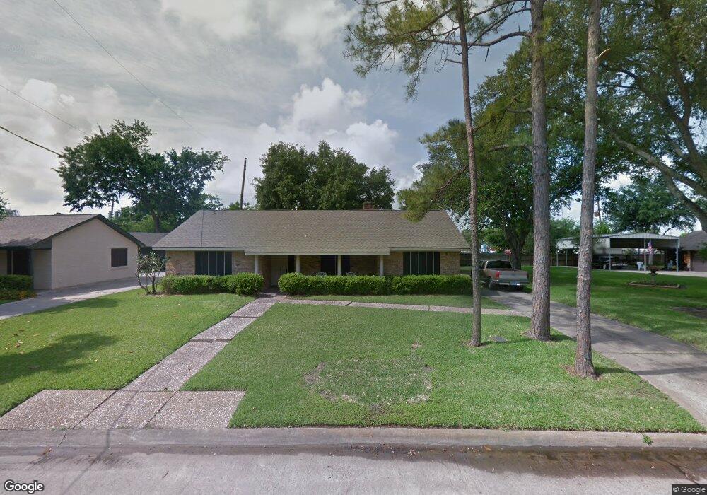
3406 Randall St Pearland, TX 77581
Estimated Value: $299,058 - $331,000
--
Bed
2
Baths
2,159
Sq Ft
$147/Sq Ft
Est. Value
About This Home
This home is located at 3406 Randall St, Pearland, TX 77581 and is currently estimated at $317,765, approximately $147 per square foot. 3406 Randall St is a home located in Brazoria County with nearby schools including C.J. Harris Elementary School, Pearland Junior High School West, and Leon H. Sablatura Middle School.
Ownership History
Date
Name
Owned For
Owner Type
Purchase Details
Closed on
Jul 24, 2017
Sold by
Ford Billy Dave
Bought by
Ford Billy Dave and Ford Beverly A
Current Estimated Value
Home Financials for this Owner
Home Financials are based on the most recent Mortgage that was taken out on this home.
Original Mortgage
$292,500
Interest Rate
4.61%
Mortgage Type
Reverse Mortgage Home Equity Conversion Mortgage
Create a Home Valuation Report for This Property
The Home Valuation Report is an in-depth analysis detailing your home's value as well as a comparison with similar homes in the area
Home Values in the Area
Average Home Value in this Area
Purchase History
| Date | Buyer | Sale Price | Title Company |
|---|---|---|---|
| Ford Billy Dave | -- | None Available |
Source: Public Records
Mortgage History
| Date | Status | Borrower | Loan Amount |
|---|---|---|---|
| Closed | Ford Billy Dave | $292,500 |
Source: Public Records
Tax History Compared to Growth
Tax History
| Year | Tax Paid | Tax Assessment Tax Assessment Total Assessment is a certain percentage of the fair market value that is determined by local assessors to be the total taxable value of land and additions on the property. | Land | Improvement |
|---|---|---|---|---|
| 2025 | $921 | $282,811 | $31,750 | $272,940 |
| 2023 | $921 | $233,728 | $31,750 | $287,590 |
| 2022 | $5,111 | $212,480 | $31,750 | $197,720 |
| 2021 | $4,977 | $219,070 | $31,750 | $187,320 |
| 2020 | $4,738 | $201,490 | $24,950 | $176,540 |
| 2019 | $4,308 | $159,640 | $22,680 | $136,960 |
| 2018 | $4,121 | $157,060 | $22,680 | $134,380 |
| 2017 | $3,765 | $154,000 | $22,680 | $131,320 |
| 2016 | $3,423 | $129,250 | $22,680 | $106,570 |
| 2015 | $1,601 | $115,230 | $22,680 | $92,550 |
| 2014 | $1,601 | $113,810 | $22,680 | $91,130 |
Source: Public Records
Map
Nearby Homes
- 3414 E Walnut St
- 0 Lockheed St
- 3320 Churchill St
- 3695 Hughes Ct
- 2708 Merlin Ln
- 2533 S Park Ave
- 3232 Lee Cir
- 2505 Kaman Ln
- 2107 Old Alvin Rd
- 2537 Park Ave
- 2531 Park Ave
- 2529 Park Ave
- 3234 Lee Cir
- 3203 Farmers Field St
- 2505 S Houston Ave
- 2511 S Houston Ave
- 2521 S Houston Ave
- 2517 S Houston Ave
- 2515 S Houston Ave
- 17828 S Highway 35
- 3404 Randall St
- 3408 Randall St
- 3402 Randall St
- 3405 Randall Dr
- 2510 Byron Ave
- 2408 Byron Ave
- 3401 Broadway St
- 3407 Randall St
- 3410 Randall St
- 2406 Byron Ave
- 3312 Randall St
- 3312 Randall Dr
- 2407 Shelia St
- 0 Cr 132 Unit 69859450
- 2412 Shelia St
- 3404 Jacquelyn Dr
- 2411 Byron Ave
- 2404 Byron Ave
- 2409 Byron Ave
- 3303 Randall St