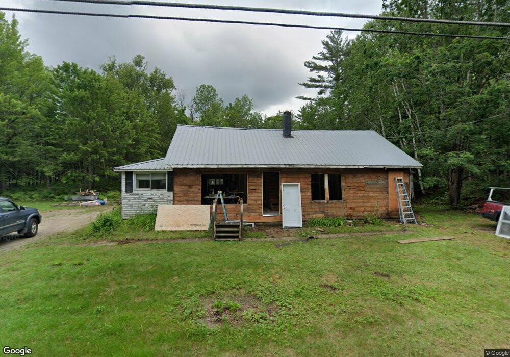
341 E Andover Rd East Andover, ME 04226
Estimated Value: $115,000 - $307,000
--
Bed
--
Bath
1,040
Sq Ft
$230/Sq Ft
Est. Value
About This Home
This home is located at 341 E Andover Rd, East Andover, ME 04226 and is currently estimated at $239,477, approximately $230 per square foot. 341 E Andover Rd is a home with nearby schools including Telstar Middle School and Telstar High School.
Ownership History
Date
Name
Owned For
Owner Type
Purchase Details
Closed on
Mar 6, 2024
Sold by
Tucker Land Company Llc
Bought by
Brown Mark C
Current Estimated Value
Home Financials for this Owner
Home Financials are based on the most recent Mortgage that was taken out on this home.
Original Mortgage
$240,000
Outstanding Balance
$235,589
Interest Rate
6.69%
Mortgage Type
Purchase Money Mortgage
Estimated Equity
$3,888
Purchase Details
Closed on
Mar 22, 2023
Sold by
Tubias Edward P Est and Bullock
Bought by
Tucker Land Company Llc
Create a Home Valuation Report for This Property
The Home Valuation Report is an in-depth analysis detailing your home's value as well as a comparison with similar homes in the area
Home Values in the Area
Average Home Value in this Area
Purchase History
| Date | Buyer | Sale Price | Title Company |
|---|---|---|---|
| Brown Mark C | -- | None Available | |
| Tucker Land Company Llc | $85,000 | None Available |
Source: Public Records
Mortgage History
| Date | Status | Borrower | Loan Amount |
|---|---|---|---|
| Open | Brown Mark C | $240,000 |
Source: Public Records
Tax History Compared to Growth
Tax History
| Year | Tax Paid | Tax Assessment Tax Assessment Total Assessment is a certain percentage of the fair market value that is determined by local assessors to be the total taxable value of land and additions on the property. | Land | Improvement |
|---|---|---|---|---|
| 2025 | $2,265 | $104,365 | $28,511 | $75,854 |
| 2024 | $1,905 | $104,365 | $28,511 | $75,854 |
| 2023 | $1,604 | $103,499 | $28,511 | $74,988 |
| 2022 | $1,542 | $103,499 | $28,511 | $74,988 |
| 2021 | $1,449 | $103,499 | $28,511 | $74,988 |
| 2020 | $1,397 | $103,500 | $28,512 | $74,988 |
| 2019 | $1,553 | $103,500 | $28,512 | $74,988 |
| 2018 | $1,625 | $103,500 | $28,512 | $74,988 |
| 2017 | $2,005 | $87,938 | $14,938 | $73,000 |
| 2016 | $2,168 | $87,938 | $14,938 | $73,000 |
| 2015 | $1,724 | $87,938 | $14,938 | $73,000 |
| 2014 | $1,372 | $87,938 | $14,938 | $73,000 |
| 2013 | $1,275 | $87,938 | $14,938 | $73,000 |
Source: Public Records
Map
Nearby Homes
- 577 E Andover Rd
- 10 S Arm Rd
- 130 Farmers Hill Rd
- 4 Nevel Rd
- 91 Airport Rd
- 225 Main St
- 1077 S Main St
- 24 Dual Cove Point Rd
- Lot 22 Roxbury Notch Rd
- Lot 39 Sawyer Notch Rd
- Lot 27-001 Coburn Brook Rd
- 108 Coburn Brook Rd
- Map 402 Lot 7 Rd
- Lot 045 Sawyer Notch Rd
- Map 402 Lot 9
- Map 402 Lot 3
- Map 402 Lot 10
- Map 404 Lot 13
- Map 401 Lot 8 Rd
- 0 Garland Pond Rd Unit 24022621
- 264 E Andover Rd
- 309 E Andover Rd
- 171 E Andover Rd
- 241 E Andover Rd
- 235 E Andover Rd
- 222 E Andover Rd
- 341 E Andover Rd
- 341 E East Andover Rd
- 349 E Andover Rd
- 349 E Andover Rd
- 197 E Andover Rd
- 371 E Andover Rd
- 187 E Andover Rd
- 371 E Andover Rd
- 180 E Andover Rd
- 381 E Andover Rd
- 164 E Andover Rd
- 163 E Andover Rd
- 405 E Andover Rd
- 00 Farmers Hill Rd