
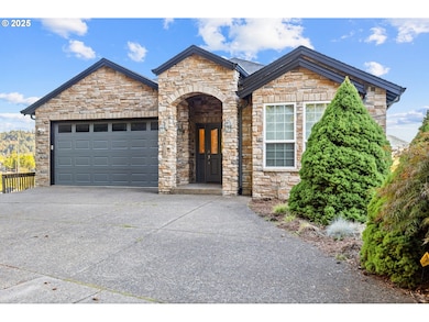
3412 NW 1st St Gresham, OR 97030
Centennial-Gresham NeighborhoodEstimated payment $5,384/month
Highlights
- Built-In Refrigerator
- Deck
- Traditional Architecture
- Mountain View
- Adjacent to Greenbelt
- Wood Flooring
About This Home
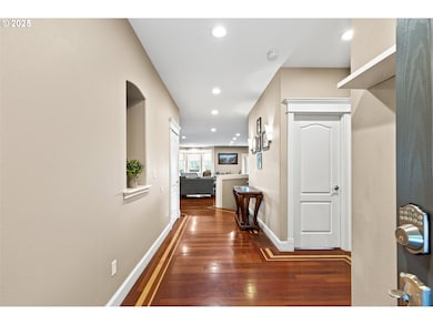
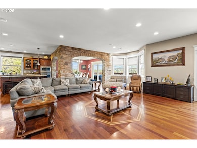
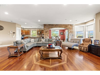
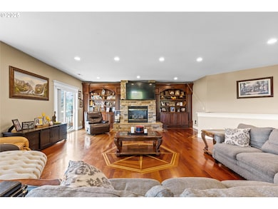
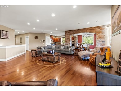
Experience breathtaking mountain and valley views from this stunning 4,643 sq ft custom-built home. Thoughtfully designed across three spacious levels, this residence features a daylight basement with 1,191 sq ft of additional living space—perfect for guests, entertainment, or multi-generational living. Enjoy seamless indoor-outdoor living with a private patio on every level, each offering a peaceful retreat to take in the natural beauty that surrounds you. Inside, the home showcases high-end finishes, including all stainless steel appliances, granite countertops, custom cabinetry, and striking stone accents throughout the main living areas. The spacious living room is centered around a cozy gas fireplace, creating a warm and inviting atmosphere year-round. A rare blend of craftsmanship, comfort, and scenery—this home is truly one of a kind.
Home Details
Home Type
- Single Family
Est. Annual Taxes
- $8,005
Year Built
- Built in 2004
Lot Details
- 11,325 Sq Ft Lot
- Adjacent to Greenbelt
- Cul-De-Sac
- Sloped Lot
- Garden
- Property is zoned LDR-5
Parking
- 2 Car Attached Garage
- Garage Door Opener
- Driveway
- On-Street Parking
Property Views
- Mountain
- Territorial
- Valley
Home Design
- Traditional Architecture
- Composition Roof
- Cement Siding
- Cultured Stone Exterior
- Concrete Perimeter Foundation
Interior Spaces
- 4,643 Sq Ft Home
- 3-Story Property
- Gas Fireplace
- Double Pane Windows
- Vinyl Clad Windows
- Family Room
- Living Room
- Dining Room
- Den
- Intercom Access
Kitchen
- Built-In Range
- Microwave
- Built-In Refrigerator
- Plumbed For Ice Maker
- Dishwasher
- Stainless Steel Appliances
- Kitchen Island
- Granite Countertops
- Disposal
Flooring
- Wood
- Wall to Wall Carpet
- Tile
Bedrooms and Bathrooms
- 5 Bedrooms
- Hydromassage or Jetted Bathtub
- Walk-in Shower
- Built-In Bathroom Cabinets
Laundry
- Laundry Room
- Washer and Dryer
Finished Basement
- Crawl Space
- Natural lighting in basement
Accessible Home Design
- Low Kitchen Cabinetry
- Accessible Hallway
- Accessibility Features
- Accessible Doors
Outdoor Features
- Deck
Schools
- Meadows Elementary School
- Centennial Middle School
- Centennial High School
Utilities
- Forced Air Heating and Cooling System
- Heating System Uses Gas
- Gas Water Heater
- High Speed Internet
Community Details
- No Home Owners Association
- Bechtoldt Single Family Subdivision
- Greenbelt
Listing and Financial Details
- Assessor Parcel Number R503441
Map
Home Values in the Area
Average Home Value in this Area
Tax History
We collect this data history from publicly available records. To have your information removed, we recommend requesting removal directly through your county’s website.
| Year | Tax Paid | Tax Assessment Tax Assessment Total Assessment is a certain percentage of the fair market value that is determined by local assessors to be the total taxable value of land and additions on the property. | Land | Improvement |
|---|---|---|---|---|
| 2025 | $8,358 | $441,350 | -- | -- |
| 2024 | $8,005 | $428,500 | -- | -- |
| 2023 | $7,208 | $416,020 | $0 | $0 |
| 2022 | $6,941 | $403,910 | $0 | $0 |
| 2021 | $6,967 | $392,150 | $0 | $0 |
| 2020 | $6,415 | $380,730 | $0 | $0 |
| 2019 | $6,258 | $369,650 | $0 | $0 |
| 2018 | $6,003 | $358,890 | $0 | $0 |
| 2017 | $5,802 | $348,440 | $0 | $0 |
| 2016 | $5,632 | $338,300 | $0 | $0 |
| 2015 | $5,481 | $328,450 | $0 | $0 |
| 2014 | $5,349 | $318,890 | $0 | $0 |
Property History
We collect this data history from publicly available records. To have your information removed, we recommend requesting removal directly through your county’s website.
| Date | Event | Price | List to Sale | Price per Sq Ft |
|---|---|---|---|---|
| 03/27/2026 03/27/26 | Price Changed | $875,000 | -1.1% | $188 / Sq Ft |
| 10/14/2025 10/14/25 | For Sale | $885,000 | -- | $191 / Sq Ft |
Purchase History
We collect this data history from publicly available records. To have your information removed, we recommend requesting removal directly through your county’s website.
| Date | Type | Sale Price | Title Company |
|---|---|---|---|
| Interfamily Deed Transfer | -- | Ticor Title Insurance Compan | |
| Warranty Deed | $30,000 | Oregon Title Insurance Co |
Mortgage History
We collect this data history from publicly available records. To have your information removed, we recommend requesting removal directly through your county’s website.
| Date | Status | Loan Amount | Loan Type |
|---|---|---|---|
| Open | $200,000 | Construction |
Source: Regional Multiple Listing Service (RMLS)
MLS Number: 687638989
APN: R503441
Disclaimer: Certain information contained herein is derived from information provided by parties other than Homes.com. All information provided is deemed reliable, but is not guaranteed to be accurate and should be independently verified.
![]() The content relating to real estate for sale on this web site comes in part from the IDX program of the RMLS™ of Portland, Oregon. Real estate listings held by brokerage firms other than Ten-X are marked with the RMLS™ logo, and detailed information about these properties includes the names of the listing brokers. Listing content is copyright © 2026 RMLS™, Portland, Oregon. Some properties which appear for sale on this web site may subsequently have sold or may no longer be available. All information provided is deemed reliable but is not guaranteed and should be independently verified.
The content relating to real estate for sale on this web site comes in part from the IDX program of the RMLS™ of Portland, Oregon. Real estate listings held by brokerage firms other than Ten-X are marked with the RMLS™ logo, and detailed information about these properties includes the names of the listing brokers. Listing content is copyright © 2026 RMLS™, Portland, Oregon. Some properties which appear for sale on this web site may subsequently have sold or may no longer be available. All information provided is deemed reliable but is not guaranteed and should be independently verified.
- 2543 NW 2nd Terrace
- 286 NW Linneman Ave
- 2477 NW 1st Dr
- 252 NW Eleven Mile Ave
- 2469 NW 1st Dr
- 181 NW Mawrcrest Ave
- 185 NW Mawrcrest Ave
- 2455 NW 1st Dr
- 2437 NW 1st Dr
- 137 NW Mawrcrest Place
- 2421 NW 1st Dr
- 153 NW Mawrcrest Place
- 165 NW Mawrcrest Place
- 177 NW Mawrcrest Place
- 2403 NW 1st Dr
- 18124 SE Bush Terrace
- 2393 SW 1st St
- 284 NW Mawrcrest Ave
- 701 SW Linneman Ct
- 2906 SE 182nd Ave
- 3437 SW 2nd St
- 2711 W Powell Blvd
- 2948 W Powell Blvd
- 2534 NW 1st Dr
- 2700 W Powell Blvd
- 4181 SW 3rd St
- 3180 NW Division St
- 2027 W Powell Blvd
- 1500 SW Pleasant View Dr
- 4777 SW 11th St
- 1132 NW Birdsdale Ave
- 4008-4140 SE 174th Ave
- 17468 SE Powell Blvd
- 17442 SE Powell Blvd
- 17930 SE Harrison St
- 2621 SE 174th Ave
- 700 SW Eastman Pkwy
- 2329 SE 174th Ave Unit 2329
- 2333 SE 174th Ave Unit 2333
- 16916-16936 SE Powell Blvd

Ask me questions while you tour the home.