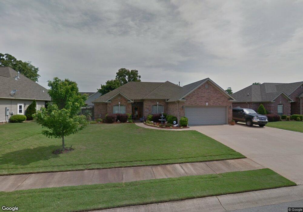
3413 Forge Dr Benton, AR 72015
Estimated Value: $302,000 - $309,000
Studio
2
Baths
1,990
Sq Ft
$153/Sq Ft
Est. Value
About This Home
This home is located at 3413 Forge Dr, Benton, AR 72015 and is currently estimated at $304,352, approximately $152 per square foot. 3413 Forge Dr is a home located in Saline County with nearby schools including Hurricane Creek Elementary School, Arkansas Christian Academy, and Our Lady Of Fatima Catholic School.
Ownership History
Date
Name
Owned For
Owner Type
Purchase Details
Closed on
Jan 5, 2005
Sold by
Dawson Paul and Dawson Linda
Bought by
Messley Charles and Messley Joanne
Current Estimated Value
Home Financials for this Owner
Home Financials are based on the most recent Mortgage that was taken out on this home.
Original Mortgage
$171,000
Outstanding Balance
$83,584
Interest Rate
5.68%
Mortgage Type
New Conventional
Estimated Equity
$220,768
Purchase Details
Closed on
Jun 16, 2004
Bought by
P and Dawson
Purchase Details
Closed on
Jun 1, 2004
Bought by
P and Dawson
Create a Home Valuation Report for This Property
The Home Valuation Report is an in-depth analysis detailing your home's value as well as a comparison with similar homes in the area
Home Values in the Area
Average Home Value in this Area
Purchase History
| Date | Buyer | Sale Price | Title Company |
|---|---|---|---|
| Messley Charles | -- | -- | |
| P | $32,000 | -- | |
| P | $32,000 | -- |
Source: Public Records
Mortgage History
| Date | Status | Borrower | Loan Amount |
|---|---|---|---|
| Open | Messley Charles | $171,000 |
Source: Public Records
Tax History
| Year | Tax Paid | Tax Assessment Tax Assessment Total Assessment is a certain percentage of the fair market value that is determined by local assessors to be the total taxable value of land and additions on the property. | Land | Improvement |
|---|---|---|---|---|
| 2025 | $2,160 | $52,015 | $9,000 | $43,015 |
| 2024 | $2,052 | $52,015 | $9,000 | $43,015 |
| 2023 | $1,735 | $52,015 | $9,000 | $43,015 |
| 2022 | $1,785 | $52,015 | $9,000 | $43,015 |
| 2021 | $1,793 | $41,600 | $7,000 | $34,600 |
| 2020 | $1,793 | $41,600 | $7,000 | $34,600 |
| 2019 | $1,793 | $41,600 | $7,000 | $34,600 |
| 2018 | $1,814 | $41,600 | $7,000 | $34,600 |
| 2017 | $1,814 | $41,600 | $7,000 | $34,600 |
| 2016 | $2,052 | $39,920 | $7,000 | $32,920 |
| 2015 | $1,686 | $39,920 | $7,000 | $32,920 |
| 2014 | $1,702 | $39,920 | $7,000 | $32,920 |
Source: Public Records
Map
Nearby Homes
- 3702 Buckskin Rd
- 3106 Briarstone Dr
- 1020 Raven Walk Dr
- 1092 Raven Walk Dr
- 1016 Raven Walk Dr
- 1032 Raven Walk Dr
- 1012 Raven Walk Dr
- 1044 Raven Walk Dr
- 1056 Raven Walk Dr
- 1052 Raven Walk Dr
- 1088 Raven Walk Dr
- 1024 Raven Walk Dr
- 1028 Raven Walk Dr
- 1080 Raven Walk Dr
- 1040 Raven Walk Dr
- 1084 Raven Walk Dr
- 1048 Raven Walk Dr
- 3158 Stonewall Dr
- 3018 Dapple Gray Rd
- 0 Liberty
- 3411 Forge Dr
- 3415 Forge Dr
- 3423 Heritage Farm Dr
- 3420 Crepe Myrtle Cove
- 3414 Forge Dr
- 3412 Forge Dr
- 3409 Forge Dr
- 3428 Crepe Myrtle Cove
- 3416 Forge Dr
- 3410 Forge Dr
- 3417 Forge Dr
- 3406 Crepe Myrtle Cove
- 3407 Forge Dr
- 3508 Crepe Myrtle Cove
- 3408 Forge Dr
- 3415 Crepe Myrtle Cove
- 3418 Forge Dr
- 0 Forge Unit 15032943
- 0 Forge Unit 17000518
- 0 Forge Unit 17004097
Your Personal Tour Guide
Ask me questions while you tour the home.