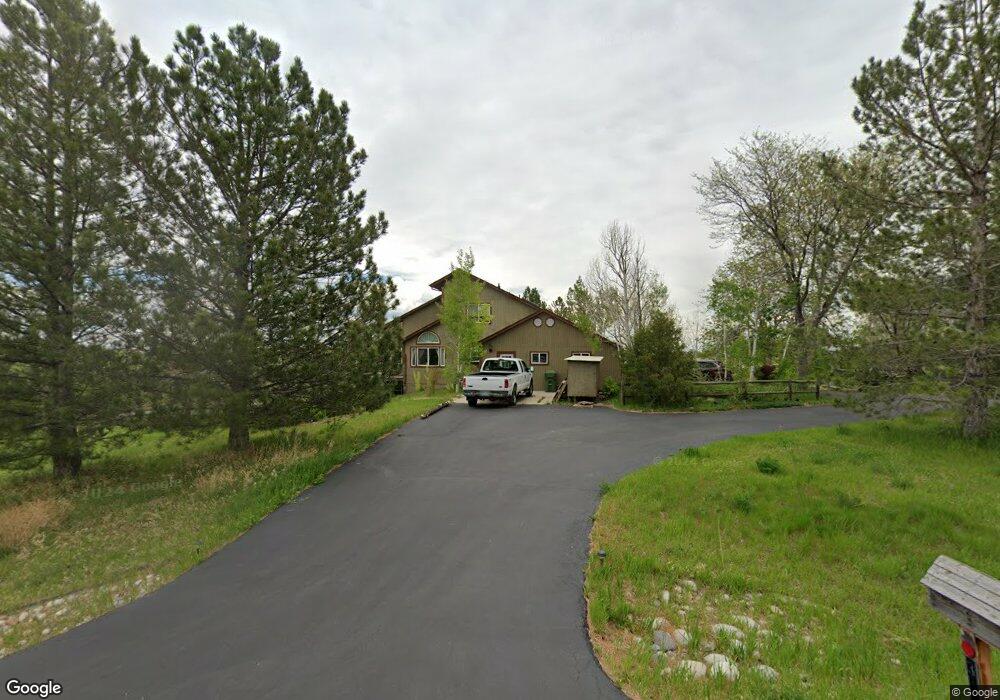
3416 Branding Iron Way Berthoud, CO 80513
Estimated Value: $821,789 - $1,114,000
4
Beds
3
Baths
2,942
Sq Ft
$326/Sq Ft
Est. Value
About This Home
This home is located at 3416 Branding Iron Way, Berthoud, CO 80513 and is currently estimated at $960,197, approximately $326 per square foot. 3416 Branding Iron Way is a home located in Larimer County with nearby schools including Berthoud Elementary School, Turner Middle School, and Berthoud High School.
Ownership History
Date
Name
Owned For
Owner Type
Purchase Details
Closed on
Mar 28, 2001
Sold by
Johnson Alan F and Johnson Eva L
Bought by
Furst Douglas K and Furst Joann L
Current Estimated Value
Home Financials for this Owner
Home Financials are based on the most recent Mortgage that was taken out on this home.
Original Mortgage
$275,000
Outstanding Balance
$101,074
Interest Rate
6.98%
Estimated Equity
$859,123
Purchase Details
Closed on
Jan 1, 1994
Sold by
Buckley Constance D
Bought by
Johnson Eva L
Create a Home Valuation Report for This Property
The Home Valuation Report is an in-depth analysis detailing your home's value as well as a comparison with similar homes in the area
Home Values in the Area
Average Home Value in this Area
Purchase History
| Date | Buyer | Sale Price | Title Company |
|---|---|---|---|
| Furst Douglas K | $368,500 | First American Heritage Titl | |
| Johnson Eva L | $239,900 | -- |
Source: Public Records
Mortgage History
| Date | Status | Borrower | Loan Amount |
|---|---|---|---|
| Open | Furst Douglas K | $275,000 |
Source: Public Records
Tax History Compared to Growth
Tax History
| Year | Tax Paid | Tax Assessment Tax Assessment Total Assessment is a certain percentage of the fair market value that is determined by local assessors to be the total taxable value of land and additions on the property. | Land | Improvement |
|---|---|---|---|---|
| 2025 | $5,936 | $57,841 | $18,425 | $39,416 |
| 2024 | $5,781 | $57,841 | $18,425 | $39,416 |
| 2022 | $5,218 | $46,002 | $8,166 | $37,836 |
| 2021 | $5,328 | $47,326 | $8,401 | $38,925 |
| 2020 | $4,739 | $40,469 | $8,401 | $32,068 |
| 2019 | $4,688 | $40,469 | $8,401 | $32,068 |
| 2018 | $4,713 | $38,938 | $8,460 | $30,478 |
| 2017 | $4,269 | $38,938 | $8,460 | $30,478 |
| 2016 | $3,996 | $34,339 | $9,353 | $24,986 |
| 2015 | $3,977 | $34,340 | $9,350 | $24,990 |
| 2014 | $2,398 | $28,780 | $9,350 | $19,430 |
Source: Public Records
Map
Nearby Homes
- 3400 Erving Ct
- 3412 Erving Ct
- 205 S County Road 23
- 3520 W County Road 8
- 0 W County Road 8e Unit RECIR1018960
- 1785 Serene Place
- 1796 Serene Place
- 1916 W County Road 6
- 560 Talons Reach Run
- 2237 W County Road 8
- 2237 W Cr8
- 4808 Beverly Dr
- 0 Beverly Dr
- 1805 W County Road 8
- 0 Rodney Ln Unit 1030974
- 871 N County Road 23e
- 1884 Chaparro Cir
- 5306 Foothills Dr
- 4329 Malibu Dr
- 1776 Glacier Ave
- 3328 Sundown Dr
- 3329 Sundown Dr
- 3401 Branding Iron Way
- 3316 Branding Iron Way
- 612 Sundown Ct
- 3329 Branding Iron Way
- 507 Chisholm Way
- 516 Chisholm Way
- 601 Sundown Ct
- 616 Sundown Ct
- 512 Chisholm Way
- 3316 Sundown Dr
- 3309 Sundown Dr
- 508 Chisholm Way
- 3308 Branding Iron Way
- 620 Sundown Ct
- 605 Sundown Ct
- 609 Sundown Ct
- 613 Sundown Ct
- 621 Sundown Ct