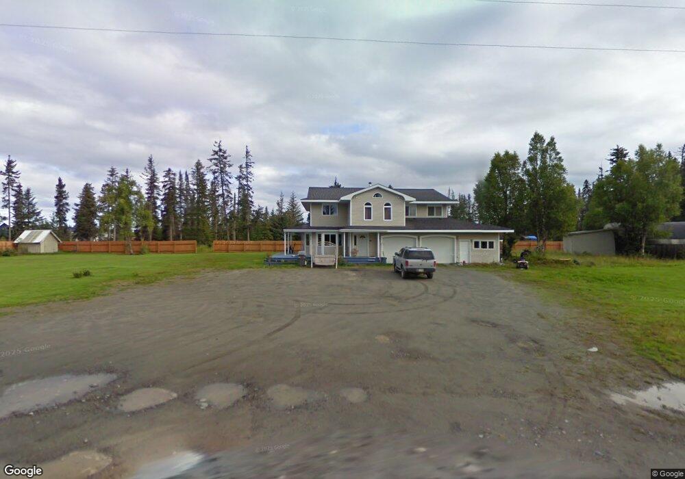
34170 Sterling Hwy Anchor Point, AK 99556
Estimated Value: $66,000 - $224,528
3
Beds
2
Baths
2,032
Sq Ft
$84/Sq Ft
Est. Value
About This Home
This home is located at 34170 Sterling Hwy, Anchor Point, AK 99556 and is currently estimated at $169,843, approximately $83 per square foot. 34170 Sterling Hwy is a home located in Kenai Peninsula Borough with nearby schools including Chapman School and Homer High School.
Ownership History
Date
Name
Owned For
Owner Type
Purchase Details
Closed on
Oct 25, 2013
Sold by
Talkington Marilyn J and Talkington Clive F
Bought by
Schnider Kyle R and Johnson Jon W
Current Estimated Value
Home Financials for this Owner
Home Financials are based on the most recent Mortgage that was taken out on this home.
Original Mortgage
$130,000
Interest Rate
5%
Mortgage Type
Seller Take Back
Create a Home Valuation Report for This Property
The Home Valuation Report is an in-depth analysis detailing your home's value as well as a comparison with similar homes in the area
Home Values in the Area
Average Home Value in this Area
Purchase History
| Date | Buyer | Sale Price | Title Company |
|---|---|---|---|
| Schnider Kyle R | -- | None Available |
Source: Public Records
Mortgage History
| Date | Status | Borrower | Loan Amount |
|---|---|---|---|
| Previous Owner | Schnider Kyle R | $130,000 |
Source: Public Records
Tax History Compared to Growth
Tax History
| Year | Tax Paid | Tax Assessment Tax Assessment Total Assessment is a certain percentage of the fair market value that is determined by local assessors to be the total taxable value of land and additions on the property. | Land | Improvement |
|---|---|---|---|---|
| 2025 | $1,387 | $173,100 | $28,100 | $145,000 |
| 2024 | $693 | $134,500 | $7,300 | $127,200 |
| 2023 | $1,293 | $120,100 | $6,700 | $113,400 |
| 2022 | $1,311 | $118,200 | $16,900 | $101,300 |
| 2021 | $1,475 | $118,500 | $16,900 | $101,600 |
| 2020 | $1,465 | $130,900 | $16,900 | $114,000 |
| 2019 | $1,476 | $132,400 | $20,100 | $112,300 |
| 2018 | $1,475 | $132,300 | $20,100 | $112,200 |
| 2017 | $1,276 | $116,500 | $20,100 | $96,400 |
| 2016 | -- | $129,000 | $20,100 | $108,900 |
| 2015 | -- | $137,600 | $20,100 | $117,500 |
| 2014 | -- | $105,400 | $20,100 | $85,300 |
Source: Public Records
Map
Nearby Homes
- 73340 School Ave
- 000 Old Sterling Hwy
- 34191 Chapman St
- L3 Aquila Wings Rd
- L1 Aquila Wings Rd
- L7 Brow Tine Rd
- L2 Aquila Wings Rd
- 73595 School Ave
- 34405 Birch St
- 34427 Birch St
- 33045 Sterling Hwy
- 73487 Ann Ct
- 33699 Granross St
- 73549 Breakaway Rd
- 73790 Cuffel Ditton Rd
- 34143 Hms Resolution Rd
- 73481 Ann Rd
- 73528 Breakaway Rd
- 72715 Kingair Ave
- 000 Anchor Point Rd
- 73135 Thurmond Dr
- 34100 Thurmond Dr
- 73113 Thurmond Ave
- 34831 Coastie Cir
- L1-21 Gateway Rd
- L1A Shorebird Ln
- L17 No Street Name
- Tr 1 Long Gone
- 32710 Shorebird Ln
- L1 B1 Appleberry
- L11 Thurmond Dr
- 73113 Thurmond Dr
- 34245 Eason Dr
- 73286 School St
- 73115 Bates Ave
- 34245 Bates Ave
- 1234 Sawmill Rd
- 73090 Thurmond Dr
- Tr B Eason Dr
- 34300 Eason Dr