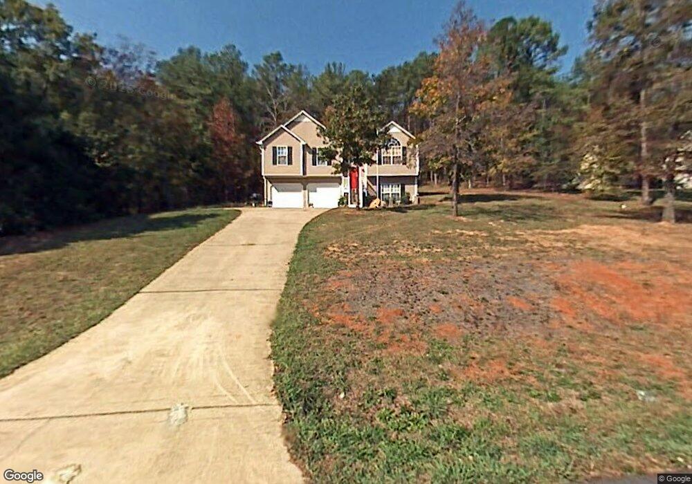
342 Amberidge Dr SE Cartersville, GA 30121
Estimated Value: $295,000 - $320,000
3
Beds
2
Baths
1,692
Sq Ft
$181/Sq Ft
Est. Value
About This Home
This home is located at 342 Amberidge Dr SE, Cartersville, GA 30121 and is currently estimated at $306,256, approximately $181 per square foot. 342 Amberidge Dr SE is a home located in Bartow County with nearby schools including Kingston Elementary School, Cass Middle School, and Cass High School.
Ownership History
Date
Name
Owned For
Owner Type
Purchase Details
Closed on
Oct 30, 2020
Sold by
Bunch Jimmy
Bought by
Bunch Maranda Nicole
Current Estimated Value
Purchase Details
Closed on
Jun 10, 2005
Sold by
Bunch Jimmy
Bought by
Bunch Jimmy and Bunch Maranda
Home Financials for this Owner
Home Financials are based on the most recent Mortgage that was taken out on this home.
Original Mortgage
$127,800
Interest Rate
7.75%
Mortgage Type
New Conventional
Create a Home Valuation Report for This Property
The Home Valuation Report is an in-depth analysis detailing your home's value as well as a comparison with similar homes in the area
Home Values in the Area
Average Home Value in this Area
Purchase History
| Date | Buyer | Sale Price | Title Company |
|---|---|---|---|
| Bunch Maranda Nicole | -- | -- | |
| Bunch Jimmy | -- | -- |
Source: Public Records
Mortgage History
| Date | Status | Borrower | Loan Amount |
|---|---|---|---|
| Previous Owner | Bunch Jimmy | $127,800 |
Source: Public Records
Tax History Compared to Growth
Tax History
| Year | Tax Paid | Tax Assessment Tax Assessment Total Assessment is a certain percentage of the fair market value that is determined by local assessors to be the total taxable value of land and additions on the property. | Land | Improvement |
|---|---|---|---|---|
| 2024 | $2,632 | $114,713 | $24,000 | $90,713 |
| 2023 | $2,632 | $107,161 | $22,600 | $84,561 |
| 2022 | $2,147 | $91,116 | $18,000 | $73,116 |
| 2021 | $1,566 | $65,309 | $18,000 | $47,309 |
| 2020 | $1,602 | $63,309 | $16,000 | $47,309 |
| 2019 | $1,315 | $52,360 | $12,000 | $40,360 |
| 2018 | $1,319 | $52,360 | $12,000 | $40,360 |
| 2017 | $1,326 | $52,360 | $12,000 | $40,360 |
| 2016 | $1,336 | $52,360 | $12,000 | $40,360 |
| 2015 | $1,386 | $54,040 | $12,000 | $42,040 |
| 2014 | -- | $41,120 | $6,000 | $35,120 |
| 2013 | -- | $34,560 | $8,000 | $26,560 |
Source: Public Records
Map
Nearby Homes
- 70 Baker Rd SE
- 1771 Joe Frank Harris Pkwy SE
- 30 Amberidge Dr NW
- 354 Oakridge Dr SE
- 261 Jordan Rd SE
- 0 Mac Johnson Rd NW Unit 7616934
- 46 Mac Johnson Rd NW
- 383 Oakridge Dr SE
- 11 Meadow View Cir
- 104 Amberidge Dr NW
- 109 Amberidge Dr NW
- 40 Bishop Mill Dr NW
- 0 Joe Frank Harris Pkwy SE Unit 7284313
- 4 Shallowood Place
- 217 Eva Way NE
- 102 Burnt Hickory Rd SW Unit Tract 2
- 273 Burnt Hickory Rd SE
- 602 Grassdale Rd
- 340 Amberidge Dr SE
- 368 Amberidge Dr SE
- 343 Amberidge Dr SE
- 338 Amberidge Dr SE
- 341 Amberidge Dr SE
- 345 Amberidge Dr SE
- 370 Amberidge Dr SE
- 339 Amberidge Dr SE
- 347 Amberidge Dr SE
- 336 Amberidge Dr SE
- 337 Amberidge Dr SE
- 383 Amberidge Dr SE
- 383 Amberidge Dr SE
- 43 Baker Rd SE
- 49 Baker Rd SE
- 334 Amberidge Dr SE
- 51 Baker Rd SE
- 335 Amberidge Dr SE
- 19 W Ridge Dr SE
- 57 Ansubet Dr SE